Avon, Alabama
Avon is a town in Houston County, Alabama, United States. It incorporated in January 1957.[4] It is part of the Dothan, Alabama Metropolitan Statistical Area. As of the 2010 census, the population of the town was 543,[2] its highest to date, up from 466 in 2000.
Avon, Alabama | |
|---|---|
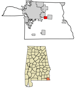 Location of Avon in Houston County, Alabama. | |
| Coordinates: 31°11′21″N 85°16′44″W | |
| Country | United States |
| State | Alabama |
| County | Houston |
| Area | |
| • Total | 2.37 sq mi (6.14 km2) |
| • Land | 2.36 sq mi (6.12 km2) |
| • Water | 0.01 sq mi (0.02 km2) |
| Elevation | 256 ft (78 m) |
| Population | |
| • Total | 543 |
| • Estimate (2019)[3] | 510 |
| • Density | 215.83/sq mi (83.32/km2) |
| Time zone | UTC-6 (Central (CST)) |
| • Summer (DST) | UTC-5 (CDT) |
| ZIP Code | 36312 |
| Area code(s) | 334 |
| FIPS code | 01-03364 |
| GNIS feature ID | 0113308 |
Geography
Avon is located near the geographic center of Houston County at 31°11′22″N 85°16′45″W (31.189409, -85.279156).[5] It is bordered to the northwest by Cowarts, and the town limits of Ashford are 0.3 miles (0.48 km) to the east. U.S. Route 84 passes through Avon, leading west 7 miles (11 km) to the center of Dothan and southeast 14 miles (23 km) to the Georgia state line at the Chattahoochee River. Bainbridge, Georgia, is 48 miles (77 km) southeast of Avon.
According to the U.S. Census Bureau, the town has a total area of 2.7 square miles (6.9 km2), of which 0.02 square miles (0.05 km2), or 0.78%, are water.[2]
Demographics
| Historical population | |||
|---|---|---|---|
| Census | Pop. | %± | |
| 1960 | 132 | — | |
| 1970 | 374 | 183.3% | |
| 1980 | 433 | 15.8% | |
| 1990 | 462 | 6.7% | |
| 2000 | 466 | 0.9% | |
| 2010 | 543 | 16.5% | |
| Est. 2019 | 510 | [3] | −6.1% |
| U.S. Decennial Census[6] | |||
2000 Census data
As of the census[7] of 2000, there were 466 people, 185 households, and 138 families residing in the town. The population density was 176.9 people per square mile (68.4/km2). There were 202 housing units at an average density of 76.7 per square mile (29.7/km2). The racial makeup of the town was 94.42% White, 4.29% Black or African American, 0.21% Native American, and 1.07% from two or more races. 0.43% of the population were Hispanic or Latino of any race.
There were 185 households, out of which 36.8% had children under the age of 18 living with them, 61.1% were married couples living together, 9.2% had a female householder with no husband present, and 24.9% were non-families. 21.1% of all households were made up of individuals, and 8.6% had someone living alone who was 65 years of age or older. The average household size was 2.52 and the average family size was 2.88.
In the town, the population was spread out, with 23.4% under the age of 18, 10.1% from 18 to 24, 32.2% from 25 to 44, 21.7% from 45 to 64, and 12.7% who were 65 years of age or older. The median age was 38 years. For every 100 females, there were 98.3 males. For every 100 females age 18 and over, there were 96.2 males.
The median income for a household in the town was $37,679, and the median income for a family was $42,273. Males had a median income of $28,438 versus $18,068 for females. The per capita income for the town was $18,152. About 9.2% of families and 12.4% of the population were below the poverty line, including 18.9% of those under age 18 and 4.3% of those age 65 or over.
References
Notes
References
- "2019 U.S. Gazetteer Files". United States Census Bureau. Retrieved June 29, 2020.
- "Geographic Identifiers: 2010 Demographic Profile Data (G001): Avon town, Alabama". American Factfinder. U.S. Census Bureau. Retrieved April 12, 2017.
- "Population and Housing Unit Estimates". United States Census Bureau. May 24, 2020. Retrieved May 27, 2020.
- http://www.encyclopediaofalabama.org/article/h-3587
- "US Gazetteer files: 2010, 2000, and 1990". United States Census Bureau. 2011-02-12. Retrieved 2011-04-23.
- "U.S. Decennial Census". Census.gov. Retrieved June 6, 2013.
- "U.S. Census website". United States Census Bureau. Retrieved 2008-01-31.
Municipalities and communities of Houston County, Alabama, United States | ||
|---|---|---|
| City | 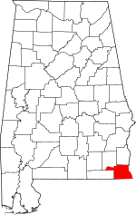 Map of Alabama highlighting Houston County | |
| Towns | ||
| Unincorporated communities | ||
| Footnotes | ‡This populated place also has portions in an adjacent county or counties | |