Ovnat
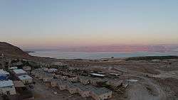
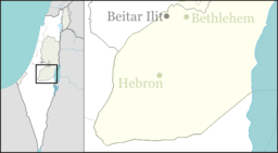
Ovnat (Hebrew: אָבְנַת) is a small Israeli settlement in the West Bank on the western shore of the Dead Sea, about 7 km (4 mi) south of Kalya and 12 km (7 mi) north of Mitzpe Shalem. It falls under the jurisdiction of Megilot Regional Council. In 2019 it had a population of 237.
Ovnat אָבְנַת | |
|---|---|
| Hebrew transcription(s) | |
| • official | Avenat, Avnat |
 | |
 Ovnat | |
| Coordinates: 31°40′45.12″N 35°26′12.47″E | |
| Country | Israel |
| District | Judea and Samaria Area |
| Council | Megilot |
| Region | West Bank |
| Founded | 2004 |
| Population (2019)[1] | 237 |
The international community considers Israeli settlements in the West Bank illegal under international law, but the Israeli government disputes this.[2]
History
It was founded in mid-2004, where a Nahal settlement existed since 1983. It is named after Asenath.[3]
According to ARIJ, Israel confiscated 124 dunams of land from the Palestinian town of al-Ubeidiya in order to construct Ovnat.[4]
gollark: Well, if you make a better, smarter government, we can talk about having it do more things then.
gollark: At least it's better than a government just throwing money at the system to try and give everyone a degree they might not actually *need* in a sensible market which didn't discriminate that way.
gollark: <@!330678593904443393> Somewhat, sure!
gollark: My problem with the whole free-college/university thing (again, see here: https://slatestarcodex.com/2015/06/06/against-tulip-subsidies/) is that it's just propping up what seems to basically just be an expensive and time-consuming signalling scheme at great cost.
gollark: Frequently.
References
- "Population in the Localities 2019" (XLS). Israel Central Bureau of Statistics. Retrieved 16 August 2020.
- "The Geneva Convention". BBC News. 10 December 2009. Retrieved 27 November 2010.
- (There is a similarity in the word rhythm (hebr. "Mishkal")): Hanna Bitan (1999) 1948-1998: Fifty Years of 'Hityashvut': Atlas of Names of Settlements in Israel, Carta, p 2 ISBN 965-220-423-4 (in Hebrew)
- Al ‘Ubeidiya Town Profile, ARIJ, p. 19
This article is issued from Wikipedia. The text is licensed under Creative Commons - Attribution - Sharealike. Additional terms may apply for the media files.