Attala, Hungary
Attala | |
|---|---|
 Coat of arms | |
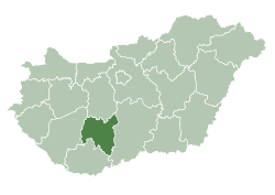
 Attala Location of Attala, Hungary | |
| Coordinates: 46.37757°N 18.06721°E | |
| Country | |
| County | Tolna |
| Area | |
| • Total | 20.64 km2 (7.97 sq mi) |
| Population (2015) | |
| • Total | 820 |
| • Density | 40/km2 (100/sq mi) |
| Time zone | UTC+1 (CET) |
| • Summer (DST) | UTC+2 (CEST) |
| Postal code | 7252 |
| Area code(s) | 74 |
| Website | http://www.attala.hu/ |
Attala is a village in Tolna County, Hungary.
Etymology
According to the local legends the name comes from the name of the mistress of Sülledvár. Her name could be Atala. She committed blasphemy as the legend says and her castle sank into the ground. There was indeed a castle during the Roman times.
The accepted theory states that the name could came from the person name Attila.[1]
History
According to László Szita the settlement was completely Hungarian in the 18th century.[2]
gollark: Orbital sand melting lasers are online.
gollark: ???
gollark: I'm overhauling the code such that all is to become unbee.
gollark: Relevantly, osmarks.net search may reexist soon.
gollark: ?tag create skateboard The United States Marine Corps tested the usefulness of commercial off-the-shelf skateboards during urban combat military exercises in the late 1990s in a program called Urban Warrior '99. Their special purpose was "for maneuvering inside buildings in order to detect tripwires and sniper fire".
References
External links
- Street map (in Hungarian)
| City with county rights |
|   |
|---|---|---|
| Towns | ||
| Large villages | ||
| Villages |
| |
| Other topics |
| |
This article is issued from Wikipedia. The text is licensed under Creative Commons - Attribution - Sharealike. Additional terms may apply for the media files.