Atsuma, Hokkaido
Atsuma (厚真町, Atsuma-chō) is a town located in Iburi Subprefecture, Hokkaido, Japan.
Atsuma 厚真町 | |
|---|---|
Town | |
Flag  Emblem | |
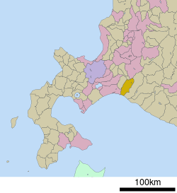
 Location of Atsuma in Hokkaido (Iburi Subprefecture) | |
 Atsuma Location in Japan | |
| Coordinates: 42°43′25″N 141°52′40″E | |
| Country | Japan |
| Region | Hokkaido |
| Prefecture | Hokkaido (Iburi Subprefecture) |
| District | Yūfutsu |
| Area | |
| • Total | 404.56 km2 (156.20 sq mi) |
| Population (March 31, 2017) | |
| • Total | 4,659 |
| • Density | 12/km2 (30/sq mi) |
| Time zone | UTC+9 (JST) |
| Website | www |
In March 2017, the town had an estimated population of 4,659, and a density of 12 persons per km². The total area is 404.56 km². The annual town festival is in mid-July, and is called "Inaka Matsuri" or "Country Festival". It is a two-day affair that starts in the main section of town with a parade featuring the Atsuma Dance and continuing the next day with performances at the Atsuma Dam.
There is a surfing beach nearby where the annual "Hama Matsuri" or "Beach Festival" in early-August.
Geography
Atsuma has several rivers of which the most prominent is the Atsuma River. It is dammed in the northern area of town and continues down through the center of town and empties into the ocean near the ferry terminal and the Tomato-Atsuma Power Station.
History
On 6 September 2018, Atsuma was the town hardest hit by the 2018 Hokkaido Eastern Iburi earthquake. It caused landslides that killed several of the town's residents when their homes were buried.[1]
Education
Atsuma currently has a high school, called the Hokkaido Atsuma High School (北海道厚真高等学校, Hokkaidō Atsuma Kōtōgakkō) The town also has two junior high schools and two elementary schools.
Transportation
Railway
- JR Hokkaido
Highways
References
- "Japan Earthquake death toll: How many dead in 6.7-magnitude earthquake in Hokkaido?". Daily Express. Retrieved 2018-09-07.
External links

- Official Website (in Japanese)