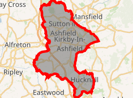
Ashfield District
Ashfield (/ˈæʃˌfiːld/) is a local government district in western Nottinghamshire, England. According to the 2001 UK census, it has a population of 111,387, increasing to 119,497 at the 2011 Census.[2] The district is mostly urban and contains parts of both the Nottingham Urban Area and the Mansfield Urban Area. The area has a tradition of coal mining. There are three towns in the district; the largest being Sutton-in-Ashfield. Settlements in the district include the following:
- Annesley, Annesley Woodhouse
- Felley
- Hucknall
- Huthwaite
- Jacksdale
- Kirkby-in-Ashfield
- Selston
- Stanton Hill
- Sutton-in-Ashfield
- Teversal
- Underwood
Ashfield District | |
|---|---|
District | |
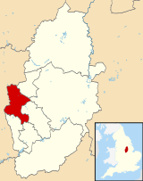 Shown within Nottinghamshire | |
| Sovereign state | United Kingdom |
| Constituent country | England |
| Region | East Midlands |
| Administrative county | Nottinghamshire |
| Admin. HQ | Kirkby-in-Ashfield |
| Government | |
| • Type | Ashfield District Council |
| • Leadership: | Leader & Cabinet |
| • Leader: | Jason Zadrozny (Ashfield Independents) |
| • MPs: | Lee Anderson Mark Spencer |
| Area | |
| • Total | 42.3 sq mi (109.6 km2) |
| Area rank | 208th |
| Population (mid-2019 est.) | |
| • Total | 127,918 |
| • Rank | Ranked 181st |
| • Density | 3,000/sq mi (1,200/km2) |
| Time zone | UTC+0 (Greenwich Mean Time) |
| • Summer (DST) | UTC+1 (British Summer Time) |
| ONS code | 37UB (ONS) E07000170 (GSS) |
| Ethnicity | 97.6% White (96.0% White British) 1.0% Asian 0.5% Black 1.0% Mixed 0.1% Other [1] |
| Website | ashfield.gov.uk |
| |
The district was formed on 1 April 1974, under the Local Government Act 1972, by the merger of urban districts of Hucknall, Kirkby-in-Ashfield, and Sutton-in-Ashfield and parts of Basford Rural District namely the parishes of Annesley, Felley and Selston.
In spring 1986, all departments, except for Direct Works, moved into purpose-built office accommodation in the centre of Kirkby-in-Ashfield. These offices provide civic accommodation for members, together with a Council Chamber and two Committee Rooms. District Offices have been maintained at Watnall Road, Hucknall, and Fox Street, Sutton-in-Ashfield, to cater for housing matters and cash receipts on a local basis.
Politics
Elections to the district are held every 4 years, with currently 35 councillors being elected from 23 wards.
| Year | Labour | Ashfield Independents | Conservative | Liberal Democrat | Independent |
|---|---|---|---|---|---|
| 2011[3] | 24 | 0 | 1 | 6 | 1 |
| 2015[4] | 22 | 0 | 4 | 5 | 2 |
| 2019[5] | 2 | 30 | 3 | 0 | 0 |
References
- http://www.ons.gov.uk/ons/rel/census/2011-census/key-statistics-for-local-authorities-in-england-and-wales/rft-table-ks201ew.xls
- "Local Authority population 2011". Neighbourhood Statistics. Office for National Statistics. Retrieved 3 April 2016.
- "Local Elections Archive Project - 2011 - Ashfield". www.andrewteale.me.uk. Retrieved 23 June 2020.
- "Local Elections Archive Project - 2015 - Ashfield". www.andrewteale.me.uk. Retrieved 23 June 2020.
- "Ashfield District Council Election results for 2019". BBC News. June 2019.
External links
| Unitary authorities | |
|---|---|
| Boroughs or districts | |
| Major settlements | |
| Topics |
|