High Peak, Derbyshire
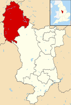
High Peak is a borough in Derbyshire, England. Administered by High Peak Borough Council from Buxton and Glossop, it is mostly composed of high moorland plateau in the Dark Peak area of the Peak District National Park. The district stretches from Holme Moss in the north to Sterndale Moor in the south and from Hague Bar in the west to Bamford in the east. The population of the borough taken at the 2011 Census was 90,892.[2]
Borough of High Peak | |
|---|---|
 Shown within Derbyshire and England | |
| Sovereign state | United Kingdom |
| Constituent country | England |
| Region | East Midlands |
| Ceremonial county | Derbyshire |
| Admin. HQ | Buxton and Glossop[1] |
| Government | |
| • Type | Non-metropolitan district; Borough |
| • Body | High Peak Borough Council |
| • Leadership: | Cllr Anthony McKeown (L) |
| • Executive: | Labour |
| • MPs: | Robert Largan (C) |
| • Mayor | Cllr Edward Kelly (L) |
| Area | |
| • Total | 208.1 sq mi (539.1 km2) |
| Area rank | 85th |
| Population (mid-2019 est.) | |
| • Total | 92,666 |
| • Rank | Ranked 262nd |
| • Density | 450/sq mi (170/km2) |
| Time zone | UTC+0 (Greenwich Mean Time) |
| • Summer (DST) | UTC+1 (British Summer Time) |
| Postcode | |
| ONS code | 17UH (ONS) E07000037 (GSS) |
| Ethnicity | 97.0% White |
| Website | highpeak.gov.uk |
High Peak was the name of a hundred of the ancient county of Derbyshire covering roughly the same area as the current district. It may have derived its name from the ancient Forest of High Peak a royal hunting reserve, administered by William Peverel, a favourite of William I, who was based at Peak Castle. High Peak contains much of the Peak District National Park.
The district contains the highest point in Derbyshire, Kinder Scout, which stands at 636m (2,087 ft) above sea level.
Creation
The borough was formed on 1 April 1974, by absorbing the municipal boroughs of Buxton and Glossop, the urban districts of New Mills and Whaley Bridge and the rural district of Chapel-en-le-Frith, all of which had previously been in the administrative county of Derbyshire, as well as the rural district of Tintwistle and Woodhead which had been in the administrative county of Cheshire.
Neighbouring local government districts
The borough adjoins the metropolitan boroughs of Sheffield and Barnsley in South Yorkshire, Kirklees in West Yorkshire, the districts of Derbyshire Dales, Cheshire East and Staffordshire Moorlands and the Stockport, Tameside and Oldham metropolitan boroughs in Greater Manchester. The Metropolitan Borough of Oldham is only bordered by high moorland near Black Hill and is not accessible by road.
Main settlements
There are five main areas of settlement in the borough: around Buxton in the south west, around New Mills in the west, around Glossop in the north west, around Whaley Bridge and Chapel-en-le-Frith in the central part of the borough, and the Hope Valley in the east. The northern part of the borough is close to the Manchester urban area. Some of the northern parts of High Peak were considered for inclusion in Greater Manchester. These areas have closer links to Stockport and Manchester than to settlements nearer Derby. Similarly, the villages of the Hope Valley are more closely linked to Sheffield and it has been considered whether these communities should be incorporated into that city.
Settlements in the borough include:
.svg.png)
- Ashopton
- Bamford
- Brough and Shatton
- Buxton
- Buxworth
- Castleton
- Chapel-en-le-Frith
- Charlesworth
- Chinley
- Chisworth
- Crowden
- Derwent
- Dove Holes
- Edale
- Fernilee
- Furness Vale
- Gamesley
- Glossop
- Hadfield
- Hayfield
- Hope
- Horwich End
- New Mills
- Old Glossop
- Padfield
- Peak Forest
- Peak Dale
- Rowarth
- Sparrowpit
- Taxal
- Tintwistle
- Thornhill
- Whaley Bridge
- Woodhead
The larger settlements are Glossop, Buxton, New Mills, Chapel-en-le-Frith and Whaley Bridge, which contain most of the services for the borough such as retail, public sector, leisure and entertainment as well as most of the major transport links such as railways and buses.
National Trust
The National Trust is a major landowner in the district, owning extensive tracts of moorland and a number of farms, including some in Edale. Features of the Trust's High Peak Estate include Kinder Scout, Odin Mine and Mam Tor.
References
- "High Peak Borough Council: Find Us". Archived from the original on 2011-06-12.
- "Borough Council population 2011". Neighbourhood Statistics. Office for National Statistics. Retrieved 23 March 2016.
| Wikimedia Commons has media related to High Peak. |
