Ash, Derbyshire
Ash is a small civil parish in the South Derbyshire district of Derbyshire, with a population of 98 (2001 census). The parish includes scattered hamlets and Ashe Hall. Today Ashe hall is the Tara Buddhist Centre.[1]
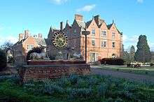
Ashe Hall
| Ash | |
|---|---|
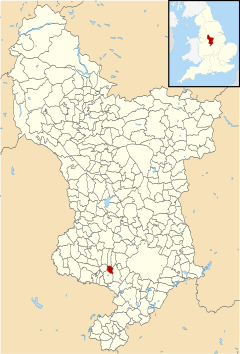 Ash parish highlighted within Derbyshire | |
| OS grid reference | SK256327 |
| District | |
| Shire county | |
| Region | |
| Country | England |
| Sovereign state | United Kingdom |
| Post town | DERBY |
| Postcode district | DE65 |
| Police | Derbyshire |
| Fire | Derbyshire |
| Ambulance | East Midlands |
History
Ash was listed in the Domesday book as Ashe in the hundred of Appletree,[2] belonging to Henry de Ferrers[3] and being worth thirty shillings.[4] The village was still known as Ashe in 1646,[5] then after 1770 was usually written as Ash.[6][7][8]
gollark: Read the privacy policy.
gollark: PotatOS doesn't spy on you.
gollark: I do own the company, after all.
gollark: PC_Cat: PotatOS inevitably.
gollark: The Chorus City signs use it.
References
- Established by meditation Master Venerable Geshe Kelsang Gyatso in Derbyshire in 1983 Tara Centre is a Kadampa Buddhist college and meditation centre, the building has 38 acres (150,000 m2) grounds and a tea room.
- Open Domesday Online: Ashe, accessed May 2018.
- Henry was given a large number of manors in Derbyshire including Doveridge, Breaston, Duffield and Cowley.
- Ashe [sic] in Domesday Book: A Complete Translation. London: Penguin, 2003. ISBN 0-14-143994-7 p.746
- Map of Derbyshire (1646) by Joan Blaeu. Description: 1 Karte : Kupferdruck ; 37 x 48 cm Creator: Blaeu Publisher: Joan Blaeu. Accessed May 2018.
- A Modern MAP of DERBY SHIRE Drawn from the latest Surveys' by J. Ellis c.1765
- Map of Derbyshire LIV.NW (includes: Ash; Bearwardcote; Burnaston; Dalbury Lees; Etwall; Hilton.) Revised: 1899 to 1900. Published: 1901. Accessed via National Library of Scotland, May 2018.
- Map of Derbyshire LIV.NW (includes: Ash; Bearwardcote; Burnaston; Dalbury Lees; Etwall; Hilton.) Surveyed: 1880 to 1881. Published: 1885. Accessed via National Library of Scotland, May 2018.
This article is issued from Wikipedia. The text is licensed under Creative Commons - Attribution - Sharealike. Additional terms may apply for the media files.