Arrondissement of Senlis
The arrondissement of Senlis is an arrondissement of France in the Oise department in the Hauts-de-France region. It has 132 communes.[1] Its population is 281,760 (2016), and its area is 1,344.2 km2 (519.0 sq mi).[2]
Senlis | |
|---|---|
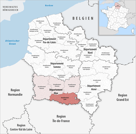 Location within the region Hauts-de-France | |
| Country | France |
| Region | Hauts-de-France |
| Department | Oise |
| No. of communes | 132 |
| Subprefecture | Senlis |
| Area | |
| • Total | 1,344.2 km2 (519.0 sq mi) |
| Population (2016) | |
| • Total | 281,760 |
| • Density | 210/km2 (500/sq mi) |
| INSEE code | 604 |
Composition
The communes of the arrondissement of Senlis, and their INSEE codes, are:[1]
- Acy-en-Multien (60005)
- Antilly (60020)
- Apremont (60022)
- Auger-Saint-Vincent (60027)
- Aumont-en-Halatte (60028)
- Autheuil-en-Valois (60031)
- Avilly-Saint-Léonard (60033)
- Balagny-sur-Thérain (60044)
- Barbery (60045)
- Bargny (60046)
- Baron (60047)
- Beaurepaire (60056)
- Belle-Église (60060)
- Béthancourt-en-Valois (60066)
- Béthisy-Saint-Martin (60067)
- Béthisy-Saint-Pierre (60068)
- Betz (60069)
- Blaincourt-lès-Précy (60074)
- Boissy-Fresnoy (60079)
- Bonneuil-en-Valois (60083)
- Boran-sur-Oise (60086)
- Borest (60087)
- Bouillancy (60091)
- Boullarre (60092)
- Boursonne (60094)
- Brasseuse (60100)
- Brégy (60101)
- Chamant (60138)
- Chambly (60139)
- Chantilly (60141)
- La Chapelle-en-Serval (60142)
- Chèvreville (60148)
- Cires-lès-Mello (60155)
- Courteuil (60170)
- Coye-la-Forêt (60172)
- Cramoisy (60173)
- Creil (60175)
- Crépy-en-Valois (60176)
- Crouy-en-Thelle (60185)
- Cuvergnon (60190)
- Dieudonné (60197)
- Duvy (60203)
- Éméville (60207)
- Ercuis (60212)
- Ermenonville (60213)
- Étavigny (60224)
- Ève (60226)
- Feigneux (60231)
- Fleurines (60238)
- Fontaine-Chaalis (60241)
- Foulangues (60249)
- Fresnoy-en-Thelle (60259)
- Fresnoy-la-Rivière (60260)
- Fresnoy-le-Luat (60261)
- Gilocourt (60272)
- Glaignes (60274)
- Gondreville (60279)
- Gouvieux (60282)
- Ivors (60320)
- Lagny-le-Sec (60341)
- Lamorlaye (60346)
- Lévignen (60358)
- Mareuil-sur-Ourcq (60380)
- Marolles (60385)
- Maysel (60391)
- Mello (60393)
- Le Mesnil-en-Thelle (60398)
- Montagny-Sainte-Félicité (60413)
- Montataire (60414)
- Montépilloy (60415)
- Mont-l'Évêque (60421)
- Montlognon (60422)
- Morangles (60429)
- Morienval (60430)
- Mortefontaine (60432)
- Nanteuil-le-Haudouin (60446)
- Néry (60447)
- Neufchelles (60448)
- Neuilly-en-Thelle (60450)
- Nogent-sur-Oise (60463)
- Ognes (60473)
- Ormoy-le-Davien (60478)
- Ormoy-Villers (60479)
- Orrouy (60481)
- Orry-la-Ville (60482)
- Péroy-les-Gombries (60489)
- Plailly (60494)
- Le Plessis-Belleville (60500)
- Pontarmé (60505)
- Pontpoint (60508)
- Pont-Sainte-Maxence (60509)
- Précy-sur-Oise (60513)
- Puiseux-le-Hauberger (60517)
- Raray (60525)
- Réez-Fosse-Martin (60527)
- Rhuis (60536)
- Roberval (60541)
- Rocquemont (60543)
- Rosières (60546)
- Rosoy-en-Multien (60548)
- Rouville (60552)
- Rouvres-en-Multien (60554)
- Rully (60560)
- Russy-Bémont (60561)
- Saintines (60578)
- Saint-Leu-d'Esserent (60584)
- Saint-Maximin (60589)
- Saint-Vaast-de-Longmont (60600)
- Saint-Vaast-lès-Mello (60601)
- Senlis (60612)
- Séry-Magneval (60618)
- Silly-le-Long (60619)
- Thiers-sur-Thève (60631)
- Thiverny (60635)
- Thury-en-Valois (60637)
- Trumilly (60650)
- Ully-Saint-Georges (60651)
- Varinfroy (60656)
- Vauciennes (60658)
- Vaumoise (60661)
- Verberie (60667)
- Verneuil-en-Halatte (60670)
- Versigny (60671)
- Ver-sur-Launette (60666)
- Vez (60672)
- La Villeneuve-sous-Thury (60679)
- Villeneuve-sur-Verberie (60680)
- Villers-Saint-Frambourg-Ognon (60682)
- Villers-Saint-Genest (60683)
- Villers-Saint-Paul (60684)
- Villers-sous-Saint-Leu (60686)
- Vineuil-Saint-Firmin (60695)
History
The arrondissement of Senlis was created in 1800.[3]
As a result of the reorganisation of the cantons of France which came into effect in 2015, the borders of the cantons are no longer related to the borders of the arrondissements. The cantons of the arrondissement of Senlis were, as of January 2015:[4]
- Betz
- Chantilly
- Creil-Nogent-sur-Oise
- Creil-Sud
- Crépy-en-Valois
- Montataire
- Nanteuil-le-Haudouin
- Neuilly-en-Thelle
- Pont-Sainte-Maxence
- Senlis
gollark: I mean, if it's fun, why not, but I don't think it's the most effective way to preserve data.
gollark: I prefer to etch my important data on the moon with lasers.
gollark: This is why you have backups.
gollark: I mean, for apocalypse-proofing, paper is probably better, but for everyday use electronically stored stuff is better I think, mostly because you can copy it.
gollark: I find digital systems waaay better for preserving things than physical media, unless there's some DRM stuff in play.
References
- "Arrondissement de Senlis (604)". INSEE. Retrieved 2019-10-02.
- "Comparateur de territoire, géographie au 01/01/2019". INSEE. Retrieved 2019-10-02.
- Historique de l'Oise
- "Populations légales 2012" (PDF). INSEE. December 2014. Retrieved 2019-10-22.
| Authority control |
|
|---|
This article is issued from Wikipedia. The text is licensed under Creative Commons - Attribution - Sharealike. Additional terms may apply for the media files.