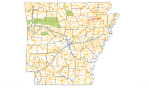
Arkansas Highway 226
Arkansas Highway 226 is a designation for two state highways in northeast Arkansas. The main segment of 25.28 miles (40.68 km) runs east from an intersection of U.S. Route 67/Arkansas Highway 367 to I-555/US 63/AR 18 in Jonesboro.[1][2] A short route of 2.38 miles (3.83 km) runs in rural Jackson County west of Tuckerman.[3]
| ||||
|---|---|---|---|---|
 | ||||
| Route information | ||||
| Maintained by AHTD | ||||
| Existed | 1958–present | |||
| Section 1 | ||||
| Length | 2.38 mi[1] (3.83 km) | |||
| West end | ||||
| East end | ||||
| Section 2 | ||||
| Length | 25.28 mi (40.68 km) | |||
| West end | ||||
| East end | ||||
| Highway system | ||||
| ||||
Route description
Western Jackson County
AR 226 runs east from Jackson CR 278 to cross AR 17 to AR 37, where it terminates.
Swifton to Jonesboro

The route then runs due east near Swifton through AR 18 in Cash, also meeting AR 349 near Jonesboro. Highway 226 winds into Jonesboro, meeting US 63/AR 18 and terminating. The route is two-lane undivided for most of its length, passing through flat, square farmland.
In 2012, construction was completed that widened four miles of the highway to a four-lane divided facility from the highway's intersection with U.S. 67 (Future I-57) to just west of Cash.[4] This was the first section of a larger plan that will ultimately widen Highway 226 to four lanes divided from U.S. 67 to U.S. 49 near Gibson.[5] Once completed, this widening project will give motorists a four-lane, divided route the entire length from Little Rock to Jonesboro.
History
The route became a state highway in 1958, traveling from an area south of Swifton east to Gibson. AR 226 was later extended to Jonesboro, including a concurrency with AR 39 (now US 49). When US 49 replaced AR 39 around 1980, AR 226 was split into its current alignment and AR 226S. The short Jackson County segment was added to the system in 1996.[1]
Had I-30 been extended, there were plans to upgrade AR 226 to Interstate standards and designate it as "Interstate 730".[6][7]
Major intersections
| County | Location | mi | km | Destinations | Notes |
|---|---|---|---|---|---|
| Jackson | | 0 | 0.0 | Western terminus. | |
| | 1.0 | 1.6 | |||
| | 2.4 | 3.9 | Eastern terminus | ||
| AR 226 short segment ends, AR 226 main segment begins at Arkansas Highway 367 | |||||
| | 0 | 0.0 | Western terminus | ||
| | 1.4 | 2.3 | |||
| Craighead | | 7.4 | 11.9 | ||
| Cash | 12.3 | 19.8 | |||
| | 19.3 | 31.1 | AR 349 southern terminus | ||
| Jonesboro | 21.0 | 33.8 | AR 139 southern terminus | ||
| 25.5 | 41.0 | I-555 exit 46; eastern terminus. | |||
1.000 mi = 1.609 km; 1.000 km = 0.621 mi
| |||||
Jonesboro spur
| |
|---|---|
| Location | Jonesboro |
| Length | 1.03 mi (1.66 km) |
| Existed | 1980–present |
Arkansas Highway 226 Spur is a spur route in Jonesboro. Known locally as Wood Springs Road, the route is 1.03 miles (1.66 km) in length.[8]
Major intersections
The entire route is in Jonesboro, Craighead County.
| mi[2] | km | Destinations | Notes | ||
|---|---|---|---|---|---|
| 0 | 0.0 | Northern terminus | |||
| 1.0 | 1.6 | Southern terminus | |||
| 1.000 mi = 1.609 km; 1.000 km = 0.621 mi | |||||
See also
References
- "[Arkansas] State Highways 2009 (Database)." April 2010. AHTD: Planning and Research Division. Database. Archived 2011-07-07 at the Wayback Machine Retrieved May 10, 2011.
- General Highway Map - Craighead County, Arkansas (PDF) (Map) (11/12/2009 ed.). Arkansas State Highway and Transportation Department. Retrieved May 10, 2011.
- General Highway Map - Jackson County, Arkansas (PDF) (Map) (10/21/2010 ed.). Arkansas State Highway and Transportation Department. Retrieved May 10, 2011.
- See AHTD Information release at http://www.arkansashighways.com/news/2010/AHC027_CRAIGHEAD.pdf, accessed 5-30-2013
- See AHTD Information Release at http://www.arkansashighways.com/news/2010/104.pdf, accessed 5-30-2013.
- "A Faster Trip From Region 8". Jonesboro, AR: KAIT-TV. March 12, 2003. Archived from the original on September 21, 2016. Retrieved July 18, 2016.
- "Jonesboro Chamber of Commerce Headed to Nation's Capitol". Jonesboro, AR: KAIT-TV. February 20, 2004. Retrieved July 18, 2016.
- Map of Jonesboro, Craighead County (Map) (October 30, 2006 ed.). Arkansas State Highway and Transportation Department. Retrieved May 10, 2011.
External links
![]()
