Arivaca Junction, Arizona
Arivaca Junction is a census-designated place (CDP) in Pima County, Arizona. The population was 1,090 at the 2010 census. As of July 1, 2015, it had an estimated population of 1,065.[4] It has an estimated elevation of 3,140 feet (960 m) above sea level.[2]
Arivaca Junction, Arizona | |
|---|---|
Census Designated Place | |
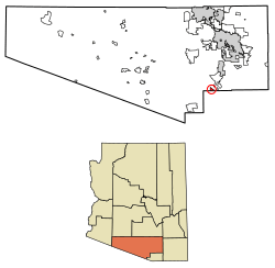 Location of Arivaca Junction in Pima County, Arizona. | |
 Arivaca Junction, Arizona Location of Arivaca Junction in Arizona | |
| Coordinates: 31°44′20″N 111°04′26″W | |
| Country | United States |
| State | Arizona |
| County | Pima |
| Area | |
| • Total | 2.92 sq mi (7.57 km2) |
| • Land | 2.92 sq mi (7.57 km2) |
| • Water | 0.00 sq mi (0.00 km2) |
| Elevation | 3,140 ft (957 m) |
| Population (2010) | |
| • Total | 1,090 |
| • Estimate (2016)[3] | N/A |
| Time zone | UTC-7 (Mountain (MST)) |
| • Summer (DST) | UTC-7 (MST) |
| Area code(s) | 520 |
| FIPS code | 04-03380 |
| GNIS feature ID | 2582731 |
Demographics
| Historical population | |||
|---|---|---|---|
| Census | Pop. | %± | |
| 2010 | 1,090 | — | |
| U.S. Decennial Census[5] | |||
gollark: It actually stops eventually due to ???, but roughly.
gollark: That was fun.
gollark: Oh yes, the traffic lights lased speeding things.
gollark: If I had unreasonable amounts of lasers and somehow access to all roads, I would install laßer turtles on each road with PotatOS Orbital LaserOS™ running on them.
gollark: I had a partnership with Keansia to install laser turtles on their roads as traffic lights, but we had too few and they sometimes destroyed roads.
References
- "2016 U.S. Gazetteer Files". United States Census Bureau. Retrieved Jul 18, 2017.
- "Feature Detail Report for: Arivaca Junction". Geographic Names Information System. United States Geological Survey.
- "Population and Housing Unit Estimates". Retrieved June 9, 2017.
- "Arivaca Junction, AZ Profile: Facts, Map & Data". AZ Hometown Locator. Retrieved January 22, 2016.
- "Census of Population and Housing". Census.gov. Retrieved June 4, 2016.
This article is issued from Wikipedia. The text is licensed under Creative Commons - Attribution - Sharealike. Additional terms may apply for the media files.