Argyle station (CTA)
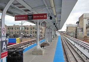
Argyle is a station on the Chicago Transit Authority's 'L' system. It is situated between the Berwyn and Lawrence stations on the Red Line, which runs from Rogers Park at Chicago's northern city limits, through downtown Chicago, to Roseland. It is an elevated station with a single island platform located at 1118 West Argyle Street in the West Argyle Street Historic District of Chicago's Uptown community area.
Argyle 5000N 1200W | |||||||||||||||||||||||||||||||||||||||||||||||||||||||||||||||||||||||||||||||||||||
|---|---|---|---|---|---|---|---|---|---|---|---|---|---|---|---|---|---|---|---|---|---|---|---|---|---|---|---|---|---|---|---|---|---|---|---|---|---|---|---|---|---|---|---|---|---|---|---|---|---|---|---|---|---|---|---|---|---|---|---|---|---|---|---|---|---|---|---|---|---|---|---|---|---|---|---|---|---|---|---|---|---|---|---|---|---|
| Chicago 'L' rapid transit station | |||||||||||||||||||||||||||||||||||||||||||||||||||||||||||||||||||||||||||||||||||||
 | |||||||||||||||||||||||||||||||||||||||||||||||||||||||||||||||||||||||||||||||||||||
| Location | 1118 West Argyle Street Chicago, Illinois 60640 | ||||||||||||||||||||||||||||||||||||||||||||||||||||||||||||||||||||||||||||||||||||
| Coordinates | 41.973365°N 87.658561°W | ||||||||||||||||||||||||||||||||||||||||||||||||||||||||||||||||||||||||||||||||||||
| Owned by | Chicago Transit Authority | ||||||||||||||||||||||||||||||||||||||||||||||||||||||||||||||||||||||||||||||||||||
| Line(s) | North Side Main Line | ||||||||||||||||||||||||||||||||||||||||||||||||||||||||||||||||||||||||||||||||||||
| Platforms | 1 Island platform | ||||||||||||||||||||||||||||||||||||||||||||||||||||||||||||||||||||||||||||||||||||
| Tracks | 4 | ||||||||||||||||||||||||||||||||||||||||||||||||||||||||||||||||||||||||||||||||||||
| Construction | |||||||||||||||||||||||||||||||||||||||||||||||||||||||||||||||||||||||||||||||||||||
| Structure type | Embankment | ||||||||||||||||||||||||||||||||||||||||||||||||||||||||||||||||||||||||||||||||||||
| History | |||||||||||||||||||||||||||||||||||||||||||||||||||||||||||||||||||||||||||||||||||||
| Opened | Chicago & Evanston Railroad: May 21, 1885 Northwestern Elevated Railroad: May 16, 1908 | ||||||||||||||||||||||||||||||||||||||||||||||||||||||||||||||||||||||||||||||||||||
| Rebuilt | 1921, 2012 | ||||||||||||||||||||||||||||||||||||||||||||||||||||||||||||||||||||||||||||||||||||
| Previous names | Argyle Park | ||||||||||||||||||||||||||||||||||||||||||||||||||||||||||||||||||||||||||||||||||||
| Traffic | |||||||||||||||||||||||||||||||||||||||||||||||||||||||||||||||||||||||||||||||||||||
| Passengers (2019) | 970,130[1] | ||||||||||||||||||||||||||||||||||||||||||||||||||||||||||||||||||||||||||||||||||||
| Rank | 68 out of 143 | ||||||||||||||||||||||||||||||||||||||||||||||||||||||||||||||||||||||||||||||||||||
| Services | |||||||||||||||||||||||||||||||||||||||||||||||||||||||||||||||||||||||||||||||||||||
| |||||||||||||||||||||||||||||||||||||||||||||||||||||||||||||||||||||||||||||||||||||
| |||||||||||||||||||||||||||||||||||||||||||||||||||||||||||||||||||||||||||||||||||||
| |||||||||||||||||||||||||||||||||||||||||||||||||||||||||||||||||||||||||||||||||||||
Location
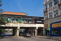
Argyle is situated on W. Argyle Street, close to the intersection with Broadway. The station is located in the West Argyle Street Historic District in the Uptown community area of Chicago; the area surrounding the station consists of a mixture commercial and residential areas,[2] and is particularly noted for the high concentration of Vietnamese restaurants, bakeries and shops; as well as Chinese, Cambodian, Laotian, and Thai businesses.[3]
History
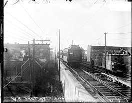
The site of Argyle station was first used as Argyle Park on the Chicago and Evanston branch of the Chicago, Milwaukee & St. Paul Railroad route, which opened on May 21, 1885.[4] On opening, the station houses along the route were described as "attractive frame structures built in the Gothic and Queen Anne styles."[4] In 1908, the Northwestern Elevated Railroad was extended north from Wilson, using the tracks of the Chicago, Milwaukee & St. Paul Railroad, and a new station was constructed on the site of the previous depot.[5][6] The station was again rebuilt to a design by architect Charles P. Rawson when the tracks between Wilson and Howard were elevated onto an embankment between 1914 and 1922.[7] In 1979, the station received a $250,000 facelift[8] and, in 1991, a Chinese-style hipped-and-gabled roof was added to the platform canopy.[9] The station was closed for renovation from August 24 to October 5, 2012.[10]
Services
Argyle is part of CTA's Red Line, which runs from the northern city limits at Howard Street to downtown Chicago and 95th street. The station has an island platform on an embankment located between Broadway and Winthrop Avenue. It serves the Red Line's two tracks; the northbound track serves trains to Howard, while the southbound track serves trains to 95th. The station entrance is located on the north side of Argyle Street, built into the embankment. It is located between the Berwyn and Lawrence stations. Red Line trains serve Argyle 24 hours a day, every day of the year; trains operate roughly every 3 to 9 minutes during rush hour and midday operation, with longer headways of up to 15 minutes at night.[11][12] The station is also located 1⁄2 a block from the 36 Broadway bus.
Notes and references
Notes
References
- "Monthly Ridership Report – December 2019" (PDF). Chicago Transit Authority, Ridership Analysis and Reporting. January 13, 2020. Retrieved March 19, 2020.
- City of Chicago Zoning Map (Map). Chicago Department of Zoning. 2010.
- "Uptown's Argyle Street Named To Historic Register". CBS2 Chicago: Chicago Area Local News. CBS Broadcasting Inc. June 14, 2010. Archived from the original on June 21, 2010. Retrieved July 29, 2010.
- "The Chicago & Evanston". Chicago Daily Tribune. May 22, 1885.
- "Electrification of the Evanston Suburban Line of the Chicago Milwaukee & St. Paul". The Railway Age. 44 (14): 467. October 4, 1907. Retrieved July 29, 2010.
- Garfield, Graham. "Argyle". Chicago-"L".org. Graham Garfield. Retrieved July 29, 2010.
- Borzo, Greg (2007). The Chicago "L". Chicago: Arcadia Publishing. p. 70. ISBN 978-0-7385-5100-5.
- Lynch, Kevin; Janega, James (April 4, 2001). "Charlie Soo 1945-2001. - Argyle Street 'Mayor,' Bold Promoter of Asian Shops". Chicago Tribune.
- McCarron, John (February 6, 1991). "'Mayor' Brings New Life to Argyle Street". Chicago Tribune.
- "Red Ahead: Argyle". Chicago Transit Authority. Retrieved December 3, 2012.
- "Red Line Route Guide". Chicago Transit Authority. Archived from the original on 22 July 2010. Retrieved July 29, 2010.
- "Argyle Station Timetable" (PDF). Chicago Transit Authority. Archived from the original (PDF) on 30 July 2010. Retrieved July 29, 2010.
- http://loyolaphoenix.com/2019/10/despite-short-term-inconveniences-cta-project-expected-to-increase-accessibility
- https://transitchicago.com/rpm/lawrmawr/
External links
| Wikimedia Commons has media related to Argyle (CTA). |