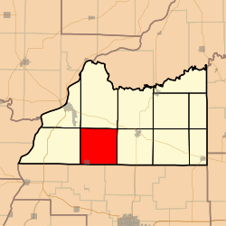
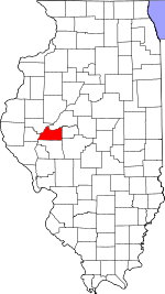
Arenzville Township, Cass County, Illinois
Arenzville Township is one of eleven townships in Cass County, Illinois, USA. As of the 2010 census, its population was 760 and it contained 343 housing units.[2]
Arenzville Township | |
|---|---|
 Location in Cass County | |
 Cass County's location in Illinois | |
| Coordinates: 39°55′14″N 90°20′06″W | |
| Country | United States |
| State | Illinois |
| County | Cass |
| Established | November 6, 1923 |
| Area | |
| • Total | 36.57 sq mi (94.7 km2) |
| • Land | 36.57 sq mi (94.7 km2) |
| • Water | 0 sq mi (0 km2) 0% |
| Elevation | 581 ft (177 m) |
| Population (2010) | |
| • Estimate (2016)[1] | 715 |
| • Density | 20.8/sq mi (8.0/km2) |
| Time zone | UTC-6 (CST) |
| • Summer (DST) | UTC-5 (CDT) |
| ZIP codes | 62611, 62618, 62691 |
| FIPS code | 17-017-01959 |
Geography
According to the 2010 census, the township has a total area of 36.57 square miles (94.7 km2), all land.[2]
Cities, towns, villages
Cemeteries
The township contains these thirteen cemeteries: Arenzville City East, Arenzville City North, Buck, Green-Krohe, Huffman, James Davis, Jockisch Methodist, Krohe, Monroe, Treadway-Miller, Trinity Lutheran, Tureman and Wiggens.
School districts
- Beardstown Community Unit School District 15
- Triopia Community Unit School District 27
- Virginia Community Unit School District 64
Political districts
- Illinois' 18th congressional district
- State House District 93
- State Senate District 47
gollark: So they can't credibly threaten anyone.
gollark: I don't think they actually have any way to find out whoever it was, except possibly hoping someone was in the room and noticed?
gollark: Who's Mr Fern? There is no such person. There has never been such a person.
gollark: Oh. Meh.
gollark: What did the ""hello" person" do exactly?
References
- "Arenzville Township, Cass County, Illinois". Geographic Names Information System. United States Geological Survey. Retrieved 2010-01-04.
- United States Census Bureau 2007 TIGER/Line Shapefiles
- United States National Atlas
- "Population and Housing Unit Estimates". Retrieved June 9, 2017.
- "Population, Housing Units, Area, and Density: 2010 - County -- County Subdivision and Place -- 2010 Census Summary File 1". United States Census. Archived from the original on 2020-02-12. Retrieved 2013-05-28.
- "Census of Population and Housing". Census.gov. Retrieved June 4, 2016.
External links
This article is issued from Wikipedia. The text is licensed under Creative Commons - Attribution - Sharealike. Additional terms may apply for the media files.