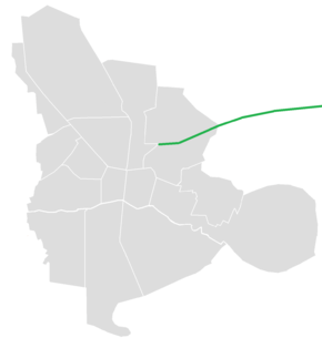
Ardestani Expressway
َArdestani Expressway (Persian: بزرگراه شهید اردستانی) is an expressway in northeastern Isfahan, Iran connecting to Isfahan International Airport via Qahjavarestan.
| |
|---|---|
| بزرگراه شهید اردستانی | |
 | |
| Route information | |
| Length | 14.7 km (9.1 mi) |
| Major junctions | |
| East end | |
| West end | |
| Location | |
| Major cities | Isfahan, Qahjavarestan |
| Highway system | |
| Highways in Iran Freeways | |
Route
Towards | ||||||
| Paygah-e haftom-e Shekari | ||||||
Municipal Districts 10 and 14 | ||||||
| Hasseh | ||||||
| 23 | ||||||
| 22 | ||||||
| 21A / 21B | Laleh Square |
|||||
| Continues as: | ||||||
gollark: I should release apiohazards as a NPM package. But what would they do?
gollark: go download bees from npm
gollark: Go Kubernetes yourself.
gollark: I mean, it's sensible for librareirieisriesiresrisrias, but for programs you might make "breaking changes" all the time and it's not sensible to increment your version.
gollark: Semantic versioning doesn't make much sense for PROGRAMS.
This article is issued from Wikipedia. The text is licensed under Creative Commons - Attribution - Sharealike. Additional terms may apply for the media files.