Arakamchechen Island
Arakamchechen Island (Russian: Аракамчечен; Eskimo–Aleut: Kigini) is an island in the Bering Sea.
| Аракамчечен / Kigini | |
|---|---|
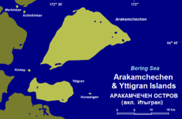 Arakamchechen and Yttygran Islands | |
 Arakamchechen Location in Russia | |
| Geography | |
| Location | Bering Sea |
| Coordinates | 64°45′N 172°23′W |
| Area | 276.8 km2 (106.9 sq mi) |
| Length | 32 km (19.9 mi) |
| Width | 21 km (13 mi) |
| Highest elevation | 613 m (2,011 ft) |
| Administration | |
Russian Federation | |
| Federal subject | Chukotka |
| Demographics | |
| Population | 0 |
Geography
Arakamchechen lies north of Cape Chaplino, close to the coast of Chukotka. It is separated from the continental shore by an 8 km wide sound. This island is inhabited; the main settlement is Yanrakynnot village.
Arakamchechen Island is 32 km long and has a maximum width of 21 km. It has a mountainous interior. South of it lies Yttygran Island and west of it Penkigney Bay.[1] There is a 5 km wide sound between the two islands.
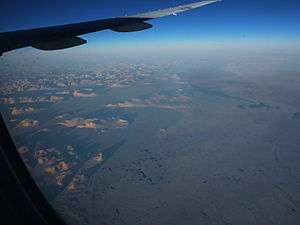 Arakamchechen (above the center of the photo) and the smaller Yttygran (left of center). The tiny island to the south of Arakamchechen is Nuneangan. |
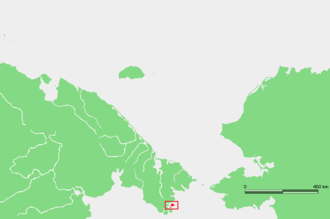 Location of Arakamchechen Island in Chukotka. |
Administration
Administratively Arakamchechen Island belongs to the Chukotka Autonomous Okrug of the Russian Federation.
Nowadays this island is popular with tourists who come to enjoy the wildlife.[2] Many walruses live in rookeries in the shores of this island.[3]
References
- "Penkigney". Mapcarta. Retrieved 9 April 2016.
- Ecotours in Russia | Sustainable tourism in Russia | fishing | expeditions Archived March 2, 2008, at the Wayback Machine
- BBC - Science & Nature - Articles - Explorer's Guide to the Arctic