Anthoston, Kentucky
Anthoston is an unincorporated community and census-designated place (CDP) in Henderson County, Kentucky, United States. It is located 6 miles (10 km) south of Henderson, the county seat, between U.S. Route 41 to the west and Interstate 69, the former Pennyrile Parkway, to the east. There is no direct access from I-69.
Anthoston, Kentucky | |
|---|---|
 Anthoston  Anthoston | |
| Coordinates: 37°45′34″N 87°32′18″W | |
| Country | United States |
| State | Kentucky |
| County | Henderson |
| Elevation | 455 ft (139 m) |
| Time zone | UTC-6 (Central (CST)) |
| • Summer (DST) | UTC-5 (CST) |
| FIPS code | 21-01720 |
| GNIS feature ID | 485968[1] |
Anthoston was first listed as a CDP in 2014, so no census population figures are available.
References
Municipalities and communities of Henderson County, Kentucky, United States | ||
|---|---|---|
| Cities | 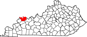 Map of Kentucky highlighting Henderson County | |
| CDPs | ||
| Other communities |
| |
| Ghost town | ||
| Footnotes | ‡This populated place also has portions in an adjacent county or counties | |
This article is issued from Wikipedia. The text is licensed under Creative Commons - Attribution - Sharealike. Additional terms may apply for the media files.