Angle Peak (Alberta)
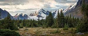
Angle Peak is a 2,910-metre (9,547 ft) mountain summit located in Jasper National Park, in the Canadian Rockies of Alberta, Canada. Angle Peak was named for the fact it stands where the ridge makes a bend.[3] The descriptive name was applied in 1916 by Morrison P. Bridgland (1878-1948), a Dominion Land Surveyor who named many peaks in Jasper Park and the Canadian Rockies.[3] [4] The mountain's name was made official in 1935 by the Geographical Names Board of Canada.[2] The mountain is situated in the Tonquin Valley, with Angle Glacier on its north slope, Alcove Mountain to its immediate west, The Ramparts 10 kilometres to the northwest, and Mount Edith Cavell 12 km to the northeast.
| Angle Peak | |
|---|---|
 Angle Peak centered | |
| Highest point | |
| Elevation | 2,910 m (9,550 ft) [1] |
| Listing | Mountains of Alberta |
| Coordinates | 52°36′36″N 118°12′43″W [2] |
| Geography | |
 Angle Peak Location of Angle Peak in Alberta  Angle Peak Angle Peak (Canada) | |
| Location | Alberta, Canada |
| Parent range | Canadian Rockies |
| Topo map | NTS 83D/09[2] |
Climate
Based on the Köppen climate classification, Angle Peak is located in a subarctic climate with cold, snowy winters, and mild summers.[5] Temperatures can drop below -20 C with wind chill factors below -30 C.
References
- Opentopemap.org
- "Angle Peak". Geographical Names Data Base. Natural Resources Canada. Retrieved 2019-01-14.
- Place-names of Alberta. Ottawa: Geographic Board of Canada. 1928. p. 11.
- Mapper of Mountains M.P. Bridgland in the Canadian Rockies 1902-1930, Author I.S. MacLaren, The University of Alberta Press, ISBN 0-88864-456-6
- Peel, M. C.; Finlayson, B. L. & McMahon, T. A. (2007). "Updated world map of the Köppen−Geiger climate classification". Hydrol. Earth Syst. Sci. 11: 1633–1644. ISSN 1027-5606.
See also
External links
- National Park Service web site: Jasper National Park