Angers – Loire Airport
Angers – Loire Airport (French: Aéroport d'Angers-Loire, IATA: ANE[2], ICAO: LFJR) is an airport located in Marcé, 20 kilometres (11 nautical miles) northeast of Angers,[1] both communes of the Maine-et-Loire department in the Pays de la Loire region of France. It is also known as Angers – Marcé Airport (French: Aéroport d'Angers – Marcé).
Angers – Loire Airport Aéroport d'Angers-Loire | |||||||||||||||||||
|---|---|---|---|---|---|---|---|---|---|---|---|---|---|---|---|---|---|---|---|
 | |||||||||||||||||||
| Summary | |||||||||||||||||||
| Airport type | Public | ||||||||||||||||||
| Operator | Société de Gestion de l'Aéroport Angers-Marcé (SGAAM) | ||||||||||||||||||
| Serves | Angers, France | ||||||||||||||||||
| Location | Marcé, France | ||||||||||||||||||
| Elevation AMSL | 59 m / 194 ft | ||||||||||||||||||
| Coordinates | 47°33′37″N 000°18′44″W | ||||||||||||||||||
| Website | AngersLoireAeroport.fr | ||||||||||||||||||
| Map | |||||||||||||||||||
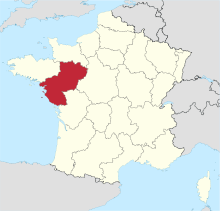
 LFJR Location of airport in Pays de la Loire Location of Pays de la Loire in France  | |||||||||||||||||||
| Runways | |||||||||||||||||||
| |||||||||||||||||||
Facilities
The airport resides at an elevation of 194 feet (59 m) above mean sea level. It has one asphalt paved runway designated 08/26 and measuring 1,800 by 45 metres (5,906 ft × 148 ft). It also has two grass runways: 08L/26R is 720 by 50 metres (2,362 ft × 164 ft) and 08R/26L is 1,100 by 100 metres (3,609 ft × 328 ft).[1]
Airlines and destinations
In April 2017 when HOP! announced a service to Bastia, the airport was not served by any scheduled commercial traffic. Previously, Angers was served during the summer by two airlines; British Airways to London-City[3] and IGavion (operated by SkyTaxi) to Nice and Toulouse.
| Airlines | Destinations |
|---|---|
| Air France Hop | Seasonal: Bastia[4] |
References
- LFJR – Angers Marcé. AIP from French Service d'information aéronautique, effective 16 July 2020.
- "IATA Airport Code Search (ANE – City: Angers, Airport: Marce)". International Air Transport Association. Retrieved 9 August 2013.
- http://www.luchtvaartnieuws.nl/nieuws/categorie/2/airlines/british-airways-meer-vluchten-vanaf-london-city
- http://www.routesonline.com/news/38/airlineroute/272316/hop-adds-bastia-seasonal-routes-in-3q17/
External links
- Angers Loire Aéroport, official site (in French)
- Aéroport d'Angers Loire at Union des Aéroports Français (in French)
- Aeronautical chart and airport information for LFJR at SkyVector
- Current weather for LFJR at NOAA/NWS