Angelica (CDP), Wisconsin
Angelica is a census-designated place in the towns of Angelica and Maple Grove in Shawano County, Wisconsin, United States. Its population was 92 as of the 2010 census.[2]
Angelica, Wisconsin | |
|---|---|
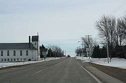 Looking south in downtown Angelica | |
 Angelica, Wisconsin | |
| Coordinates: 44°40′26″N 88°18′49″W | |
| Country | United States |
| State | Wisconsin |
| County | Shawano |
| Area | |
| • Total | 1.56 sq mi (4.05 km2) |
| • Land | 1.56 sq mi (4.05 km2) |
| • Water | 0.00 sq mi (0.00 km2) |
| Elevation | 879 ft (268 m) |
| Population | |
| • Total | 377 |
| • Estimate (2016)[3] | N/A |
| Time zone | UTC-6 (Central (CST)) |
| • Summer (DST) | UTC-5 (CDT) |
| Area code(s) | 715 & 534 |
| GNIS feature ID | 1560867[4] |
Angelica sign
Demographics
| Historical population | |||
|---|---|---|---|
| Census | Pop. | %± | |
| U.S. Decennial Census[5] | |||
gollark: Those are subdomains.
gollark: It probably doesn't matter much anyway.
gollark: https://www.pugetsystems.com/labs/articles/Thermal-Paste-Application-Techniques-170/
gollark: Unfortunately Intel hasn't really improved much for a while.EDIT: except power, faster and more expensive memory, random extensions
gollark: I like how they managed to get `feed` into that IP address.
References
- "2016 U.S. Gazetteer Files". United States Census Bureau. Retrieved Jul 19, 2017.
- "U.S. Census website". U.S. Census Bureau. Retrieved 29 March 2011.
- "Population and Housing Unit Estimates". Retrieved June 9, 2017.
- U.S. Geological Survey Geographic Names Information System: Angelica (CDP), Wisconsin
- "Census of Population and Housing". Census.gov. Retrieved June 4, 2016.
Municipalities and communities of Shawano County, Wisconsin, United States | ||
|---|---|---|
| Cities |  | |
| Villages | ||
| Towns | ||
| CDPs | ||
| Unincorporated communities | ||
| Indian reservations |
| |
| Footnotes | ‡This populated place also has portions in an adjacent county or counties | |
This article is issued from Wikipedia. The text is licensed under Creative Commons - Attribution - Sharealike. Additional terms may apply for the media files.