Andersonville, Indiana
Andersonville is an unincorporated community in Posey Township in the northwest corner of Franklin County, Indiana, United States.
Andersonville, Indiana | |
|---|---|
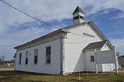 Andersonville Christian Church | |
 Andersonville | |
| Coordinates: 39°29′51″N 85°17′20″W | |
| Country | |
| State | |
| County | Franklin County |
| Township | Posey Township |
| Elevation | 320 m (1,050 ft) |
| ZIP code | 47024 |
| GNIS feature ID | 0430167 |
History
Andersonville, originally known as Ceylon, was laid out in 1837 by Fletcher Tevis. It was renamed in 1849 after Thomas Anderson, a tavern owner. In 1915, Andersonville had about 350 inhabitants.[1]
Geography
Andersonville is located at 39°29′51″N 85°17′20″W at an elevation of 1050 feet. It lies at the intersection of U.S. Route 52 and the east end of Indiana State Road 244; this forms an acute angle, and the named streets run north and south in the triangle thus formed.
Notes
- Reifel, August Jacob (1915). History of Franklin County, Indiana. Windmill Publications. pp. 126.
gollark: Basically, as it's a static site, you can't run any serverside code to fetch and display the feed.
gollark: Ah, so a static website. This might be hard, then.
gollark: <@215706991748841473> What software does your website use?
gollark: It has a mildly longer definition, but it isn't really better, and I think arbitrarily censoring legal content is actually bad.
gollark: Yes.
References
Municipalities and communities of Franklin County, Indiana, United States | ||
|---|---|---|
| City | Map of Indiana highlighting Franklin County | |
| Towns | ||
| Townships | ||
| CDPs | ||
| Other unincorporated communities |
| |
| Footnotes | ‡This populated place also has portions in an adjacent county or counties | |
This article is issued from Wikipedia. The text is licensed under Creative Commons - Attribution - Sharealike. Additional terms may apply for the media files.