Indiana State Road 244
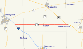
State Road 244 (SR 244) is a State Road in the eastern section of the state of Indiana. Running for about 22.3 miles (35.9 km) in a general east–west direction, connecting rural portions of Shelby, Rush, and Franklin counties. SR 244 was originally introduced in 1932 routed between SR 29 and U.S. Route 52. The road was paved in the late 1960s
| ||||
|---|---|---|---|---|
 | ||||
| Route information | ||||
| Maintained by INDOT | ||||
| Length | 22.294 mi[1] (35.879 km) | |||
| Existed | 1932[2]–present | |||
| Major junctions | ||||
| West end | Michigan Road near Shelbyville | |||
| East end | ||||
| Location | ||||
| Counties | Franklin, Rush, Shelby | |||
| Highway system | ||||
| ||||
Route description
SR 244 begins at an intersection with Michigan Road, formerly U.S. Route 421 (US 421), southeast of Shelbyville. The road heads east having an interchange with Interstate 74/US 421 at Exit 119 in Shelby County. It proceeds east entering Rush County and passing through an intersection with SR 3. East of SR 3, SR 244 enters the census-designated place of Milroy, Indiana. While in Milroy SR 244 is also known as Main Street. The highway continues east passing through rural Rush County, before entering Franklin County. Soon after entering Franklin County SR 244 enters the community of Andersonville. On the east side of Andersonville SR 244 ends at a three-way intersection with US 52.[3][4]
In 2015 the highest traffic count is at the just east of SR 3, where 2,757 vehicles travel the highway on average each day. The lowest traffic count is east of Milroy, where 782 vehicles travel the highway on average each day.[5]
History
SR 244 was first designated in 1931. The original routing started at SR 29, now Michigan Road, and ran east through rural Shelby and Rush Counties to US 52 much as it does today.[2][6] The highway had an interchange with I-74 added between 1960 and 1961.[7][8] SR 244 served as a temporary eastern end of I-74 between 1960 and 1962.[7][9] The roadway was paved in two segment the first of which was the segment in Rush County paved between 1966 and 1967.[10][11] The rest of the road was paved between 1969 and 1970.[12][13]
Major intersections
| County | Location | mi[1] | km | Destinations | Notes |
|---|---|---|---|---|---|
| Shelby | Liberty Township | 0.000 | 0.000 | Michigan Road – Waldron | Old US 421; western terminus of SR 244 |
| 0.298– 0.410 | 0.480– 0.660 | exit 119 on I-74 | |||
| Rush | Milroy | 12.016 | 19.338 | ||
| Franklin | Andersonville | 22.294 | 35.879 | Eastern terminus of SR 244 | |
| 1.000 mi = 1.609 km; 1.000 km = 0.621 mi | |||||
References
- Indiana Department of Transportation (July 2015). Reference Post Book (PDF). Indianapolis: Indiana Department of Transportation. Retrieved October 6, 2016.
- "State Begins Care New Roads". The Daily Reporter. Greenfield. March 23, 1932. p. 4. Retrieved October 4, 2016 – via Newspapers.com.

- Indiana Department of Transportation (2016). Indiana Roadway Map 2016 (PDF) (Map). 1:550,000. Indianapolis: Indiana Department of Transportation. OCLC 925532510. Retrieved November 23, 2016.
- Microsoft; Nokia (November 23, 2016). "Indiana State Road 244" (Map). Bing Maps. Microsoft. Retrieved November 23, 2016.
- Indiana Department of Transportation. "Traffic Count Database System". Indianapolis: Indiana Department of Transportation. Retrieved November 23, 2016.
- Indiana State Highway Commission (January 1, 1932). State Highway System of Indiana (Map). 1:660,000. Indianapolis: Indiana State Highway Commission. OCLC 53092152. Retrieved November 23, 2016 – via Indiana State Library and Historical Bureau.
- Indiana State Highway Department (1960). State Highway System of Indiana (Map). 1:700,000. Indiana State Highway Department. OCLC 489761071. Retrieved November 23, 2016 – via Indiana State Library and Historical Bureau.
- Indiana State Highway Commission (1961). State Highway System of Indiana (Map). 1:680,000. Indiana State Highway Commission. OCLC 55533640. Retrieved November 23, 2016 – via Indiana State Library and Historical Bureau.
- Indiana State Highway Commission (1962). State Highway System of Indiana (Map). 1:680,000. Indiana State Highway Commission. OCLC 65195920. Retrieved November 23, 2016 – via Indiana State Library and Historical Bureau.
- Indiana State Highway Commission (1966). Indiana State Highway System (Map) (1966–1967 ed.). 1:640,000. Indiana State Highway Commission. OCLC 65209231. Retrieved November 23, 2016 – via Indiana State Library and Historical Bureau.
- Indiana State Highway Commission (1967). Indiana State Highway System (Map) (1967–1968 ed.). 1:640,000. Indiana State Highway Commission. OCLC 65221593. Retrieved November 23, 2016 – via Indiana State Library and Historical Bureau.
- Indiana State Highway Commission (1969). Indiana State Highway System (Map). 1:631,000. Indiana State Highway Commission. OCLC 314731307. Retrieved November 23, 2016 – via Indiana State Library and Historical Bureau.
- Indiana State Highway Commission (1970). Indiana State Highway System (Map) (1970–1971 ed.). 1:640,000. Indiana State Highway Commission. OCLC 65221477.
