Andévalo
El Andévalo or El Campo de Andévalo is a comarca in Huelva Province, Andalusia, southern Spain. It is located between the Sierra de Huelva, Costa Occidental, Cuenca Minera, Huelva and Condado de Huelva comarcas and the border of Portugal.
El Andévalo | |
|---|---|
.JPG) Twilight landscape with Iberian pigs under oak trees in Tharsis. | |
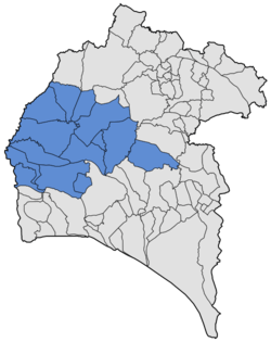 Location of El Andévalo in the province of Huelva | |
| Country | Spain |
| Region | Andalusia |
| Area | |
| • Total | 2,510 km2 (970 sq mi) |
| Elevation | 260 m (850 ft) |
| Population (2014) | |
| • Total | 38,294 |
| • Density | 15/km2 (40/sq mi) |
The present-day comarca was established in 2003.[1]
Municipal terms
- Alosno
- Cabezas Rubias
- Calañas
- El Almendro
- El Cerro de Andévalo
- El Granado
- Paymogo
- Puebla de Guzmán
- San Bartolomé de la Torre
- Sanlúcar de Guadiana
- Santa Bárbara de Casa
- Valverde del Camino
- Villanueva de las Cruces
- Villanueva de los Castillejos
gollark: Remember the good old days before pronouny fixed the issue where you could arbitrarily edit people's accounts?
gollark: Or //// (see my pronouny profile).
gollark: God is ţͦͧh́͐̍e̎̇͒y̸̯̱/t̰̺͡h̐ͤ͊ē̺̓m̘̹̑ obviously?
gollark: [<:bees:724389994663247974> EXPUNGED]
gollark: `sudo` requires it, silly.
See also
References
- Orden de 14 de marzo de 2003, por la que se aprueba el mapa de comarcas de Andalucía a efectos de la planificación de la oferta turística y deportiva, Boletín Oficial de la Junta de Andalucía; Bulletin of the Government of Andalusia, No 59; 27 March 2003, p. 6248
This article is issued from Wikipedia. The text is licensed under Creative Commons - Attribution - Sharealike. Additional terms may apply for the media files.