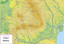
Ampoi
The Ampoi (Hungarian: Ompoly) is a river in the Apuseni Mountains, Alba County, western Romania. It is a right tributary of the river Mureș.[1][2] It flows through the town Zlatna, and joins the Mureș near Alba Iulia. Its length is 43 km (27 mi) and its basin size is 250 km2 (97 sq mi).[2]
| Ampoi Ompoly | |
|---|---|
 | |
| Location | |
| Country | Romania |
| Region | Transylvania |
| Counties | Alba County |
| Villages | Izvoru Ampoiului, Zlatna, Feneș, Meteș, Șard |
| Physical characteristics | |
| Mouth | Mureș |
• location | near Alba Iulia |
• coordinates | 46.054°N 23.597°E |
| Basin features | |
| Progression | Mureș→ Tisza→ Danube→ Black Sea |
| Tributaries | |
| • left | Vâltori, Feneș, Ampoița, Ighiu |
| • right | Galați |
Tributaries
The following rivers are tributaries to the Ampoi (from source to mouth):[2]
- Left: Valea Petrei, Vâltori, Feneș, Valea lui Bibaț, Valea Albinei, Ampoița and Ighiu
- Right: Trâmpoiele, Valea Mare, Valea Mică and Galați
gollark: Damage from cryonics is a mere (possibly 3 hard) engineering issue which will be fixed if it is fixable and technology keeps advancing.
gollark: Again, spare resources and stuff.
gollark: Maybe unfreezing people initially costs a few billion $ so only some weird billionaires are unfrozen at first, but advancing technology will make it cheaper eventually.
gollark: Historically speaking, the future has had more "spare" resources than the past.
gollark: Stupid why?
References
- "Planul național de management. Sinteza planurilor de management la nivel de bazine/spații hidrografice, anexa 7.1" (PDF, 5.1 MB). Administrația Națională Apele Române. 2010. p. 387.
- Atlasul cadastrului apelor din România. Partea 1 (in Romanian). Bucharest: Ministerul Mediului. 1992. pp. 170–171. OCLC 895459847. River code: IV.1.99
This article is issued from Wikipedia. The text is licensed under Creative Commons - Attribution - Sharealike. Additional terms may apply for the media files.