Alston, Georgia
Alston is a town in Montgomery County, Georgia, United States, with a population of 159 at the 2010 census.[5] It is part of the Vidalia Micropolitan Statistical Area.
Alston, Georgia | |
|---|---|
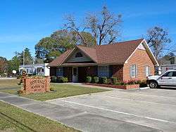 Alston City Hall | |
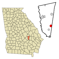 Location in Montgomery County and the state of Georgia | |
| Coordinates: 32°4′49″N 82°28′42″W | |
| Country | United States |
| State | Georgia |
| County | Montgomery |
| Area | |
| • Total | 2.87 sq mi (7.44 km2) |
| • Land | 2.85 sq mi (7.38 km2) |
| • Water | 0.03 sq mi (0.07 km2) |
| Elevation | 230 ft (70 m) |
| Population (2010) | |
| • Total | 159 |
| • Estimate (2019)[2] | 159 |
| • Density | 55.81/sq mi (21.55/km2) |
| Time zone | UTC-5 (Eastern (EST)) |
| • Summer (DST) | UTC-4 (EDT) |
| ZIP code | 30412 |
| Area code(s) | 912 |
| FIPS code | 13-01808[3] |
| GNIS feature ID | 0331031[4] |
History
The community was named after Alex Alston, a pioneer citizen.[6] A post office has been in operation at Alston since 1910.[7] Alston incorporated in 1910.[6]
Alston was the location of the murder of resident Isaiah Nixon, who was shot in his front yard in front of his wife and six children on Sept. 8, 1948, after voting in the Georgia Democratic primary.[8][9]
Geography
Alston is located at 32°04′49″N 82°28′42″W.[10]
According to the United States Census Bureau, the town has a total area of 2.9 square miles (7.5 km2), all land.
Demographics
| Historical population | |||
|---|---|---|---|
| Census | Pop. | %± | |
| 1930 | 199 | — | |
| 1940 | 213 | 7.0% | |
| 1950 | 147 | −31.0% | |
| 1960 | 154 | 4.8% | |
| 1970 | 104 | −32.5% | |
| 1980 | 111 | 6.7% | |
| 1990 | 160 | 44.1% | |
| 2000 | 159 | −0.6% | |
| 2010 | 159 | 0.0% | |
| Est. 2019 | 159 | [2] | 0.0% |
| U.S. Decennial Census[11] | |||
As of the census[3] of 2000, there were 159 people, 63 households, and 44 families residing in the town. The population density was 55.5 people per square mile (21.5/km2). There were 72 housing units at an average density of 25.2 per square mile (9.7/km2). The racial makeup of the town was 86.79% White and 13.21% African American.
There were 63 households, out of which 31.7% had children under the age of 18 living with them, 58.7% were married couples living together, 7.9% had a female householder with no husband present, and 28.6% were non-families. 25.4% of all households were made up of individuals, and 17.5% had someone living alone who was 65 years of age or older. The average household size was 2.52 and the average family size was 3.04.
In the town, the population was spread out, with 25.2% under the age of 18, 6.3% from 18 to 24, 28.3% from 25 to 44, 25.2% from 45 to 64, and 15.1% who were 65 years of age or older. The median age was 38 years. For every 100 females, there were 93.9 males. For every 100 females age 18 and over, there were 88.9 males.
The median income for a household in the town was $41,250, and the median income for a family was $48,500. Males had a median income of $33,750 versus $23,750 for females. The per capita income for the town was $18,110. About 4.0% of families and 4.5% of the population were below the poverty line, including none of those under the age of eighteen and 6.3% of those sixty five or over.
References
- "2019 U.S. Gazetteer Files". United States Census Bureau. Retrieved July 9, 2020.
- "Population and Housing Unit Estimates". United States Census Bureau. May 24, 2020. Retrieved May 27, 2020.
- "U.S. Census website". United States Census Bureau. Retrieved 2008-01-31.
- "US Board on Geographic Names". United States Geological Survey. 2007-10-25. Retrieved 2008-01-31.
- United States Census
- Krakow, Kenneth K. (1975). Georgia Place-Names: Their History and Origins (PDF). Macon, GA: Winship Press. p. 4. ISBN 0-915430-00-2.
- "Post Offices". Jim Forte Postal History. Retrieved 31 March 2018.
- "Isaiah Nixon". The Georgia Civil Rights Cold Cases Project at Emory University. Retrieved 2019-11-18.
- Hank Klibanoff (2018-03-25). "Buried Truths" (Podcast). WABE/NPR. Retrieved 2019-11-18.
- "US Gazetteer files: 2010, 2000, and 1990". United States Census Bureau. 2011-02-12. Retrieved 2011-04-23.
- "Census of Population and Housing". Census.gov. Retrieved June 4, 2015.
Municipalities and communities of Montgomery County, Georgia, United States | ||
|---|---|---|
| Cities | 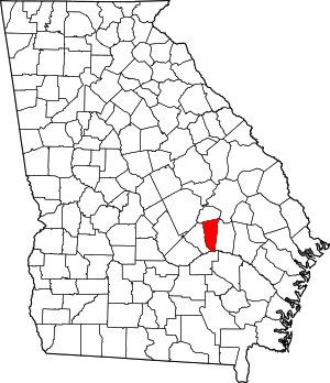 Map of Georgia highlighting Montgomery County | |
| Towns | ||
| Unincorporated communities | ||
| Footnotes | ‡This populated place also has portions in an adjacent county or counties | |