Alphubel
The Alphubel (4,206 m) is a mountain of the Swiss Pennine Alps, located between the valleys of Zermatt and Saas in the canton of Valais. It is part of the Mischabel range, which culminates at the Dom (4,545 m). The summit of the Alphubel consists of a large ice-covered plateau, part of the Fee Glacier on its east side. The west side of the mountain is more rocky and much steeper. It overlooks the Weingartensee.
| Alphubel | |
|---|---|
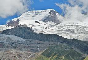 The Alphubel seen from Saas-Fee (north-east side) | |
| Highest point | |
| Elevation | 4,206 m (13,799 ft) |
| Prominence | 359 m (1,178 ft) [1] |
| Parent peak | Dom |
| Isolation | 1.9 km (1.2 mi) [2] |
| Coordinates | 46°3′46.58″N 7°51′50.08″E |
| Geography | |
 Alphubel Location in Switzerland | |
| Location | Valais, Switzerland |
| Parent range | Pennine Alps |
| Climbing | |
| First ascent | 9 August 1860 by Leslie Stephen and T. W. Hinchliff with guides Melchior Anderegg and Peter Perren |
| Easiest route | Many routes at PD |
The nearest settlements are Täsch (north of Zermatt) and Saas-Fee.
The first ascent of the mountain was by Leslie Stephen and T. W. Hinchliff with guides Melchior Anderegg and Peter Perren on 9 August 1860, starting at Täsch and via the south-east ridge and the Alphubeljoch.
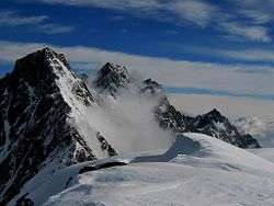
View of the Täschhorn and the Dom from the summit of the Alphubel
See also
- List of 4000 metre peaks of the Alps
References
This article is issued from Wikipedia. The text is licensed under Creative Commons - Attribution - Sharealike. Additional terms may apply for the media files.