Allawah, New South Wales
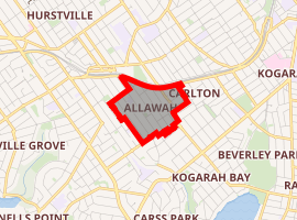
Allawah is a suburb in southern Sydney, in the state of New South Wales, Australia. Allawah is 16 kilometres south of the Sydney central business district and is part of the St George area. Allawah lies in the local government area of the Georges River Council. The postcode is 2218, which is shared by the neighbouring suburb of Carlton.[2]
| Allawah Sydney, New South Wales | |||||||||||||||
|---|---|---|---|---|---|---|---|---|---|---|---|---|---|---|---|
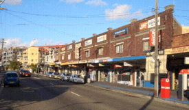
Allawah Hotel, Railway Parade | |||||||||||||||

| |||||||||||||||
| Population | 5,706 (2016 census)[1] | ||||||||||||||
| Postcode(s) | 2218 | ||||||||||||||
| Location | 15 km (9 mi) south of Sydney CBD | ||||||||||||||
| LGA(s) | Georges River Council | ||||||||||||||
| State electorate(s) | Kogarah | ||||||||||||||
| Federal Division(s) | Banks | ||||||||||||||
| |||||||||||||||


History
The name "Allawah" is Aboriginal in origin, from a local term meaning 'make your abode here' or 'remain here'. It is thought that the Aboriginal clan most prominent in the St George area, the Gameygal or Kameygal – the people of Kamay (Botany Bay), lived in and around the area.
The first land grant was made in 1808 to Captain John Townson by Major George Johnston after he had briefly deposed Governor Bligh in 1808, consisting of 1950 acres (789 hectares), which became known as Townson's Farm. The grant extended from King Georges Road and Stoney Creek Road (of modern-day Penshurst and Beverly Hills) to beyond Kogarah railway station. Later, an additional 250 acres (101 hectares) to the north was granted after Townson complained about the quality of about 300 acres (121 hectares) of this grant (in what was later to become Bexley, Carlton and Allawah).[3]
The railway line to Hurstville was opened in 1884, but the railway station at Allawah did not open until 23 October 1925.
The Allawah post office opened in May 1933.[4]
Demographics
According to the 2016 census of Population, there were 5,706 residents in Allawah. 34.7% of people were born in Australia. The next most common countries of birth were China 21.7%, Nepal 6.9%, Philippines 2.9%, Hong Kong 2.8% and India 2.5%. 27.1% of people only spoke English at home. Other languages spoken at home included Mandarin 18.7%, Cantonese 11.6%, Nepali 7.1%, Arabic 3.7% and Macedonian 2.6%. The most common responses for religious affiliation were No Religion 31.6%, Catholic 17.0% and Hinduism 9.0%.[1]
Commercial area
Allawah is a small landlocked suburb, about 15–20 minutes walking distance from Hurstville. Allawah's main shopping centre is located on Railway Parade, beside Allawah railway station. The Allawah shopping strip contains a newsagent, post office, corner store, Nepalese/Indian grocery store, real estate agency Century 21 Southside Properties, take-away shops, a computer repair business, an Internet cafe, and the local pub and bottle shop, the Allawah Hotel.
Transport
Allawah railway station is on the Illawarra line serviced by Sydney Trains. The railway station has had an upgrade in recent years, including the installation of lifts to benefit the mobility challenged. Trains to Bondi Junction and to Hurstville stop at Allawah six times an hour during peak times, and 4 times an hour at all other times except weekends. Weekends run 2 train services an hour in both directions.
Landmarks
- St Raphaels Catholic Church
- Southern Sydney Synagogue
References
- Australian Bureau of Statistics (27 June 2017). "Allawah (State Suburb)". 2016 Census QuickStats. Retrieved 26 January 2018.

- Gregory's Sydney Street Directory, Gregory's Publishing Company, 2007
- Alison Grellis (2008). "Allawah". Dictionary of Sydney. Dictionary of Sydney Trust. Retrieved 19 January 2015.
- Pollon, F. The Book of Sydney Suburbs, Angus & Robertson Publishers, Sydney, pg. 3.