Aldbrough, East Riding of Yorkshire
Aldbrough is a village and civil parish in the East Riding of Yorkshire, England, about 12 miles (19 km) north-east of Hull at the junction of the B1242 and B1238 roads. It lies near to the North Sea coast within the area of Holderness.
| Aldbrough | |
|---|---|
 The Elm Tree public house, High Street | |
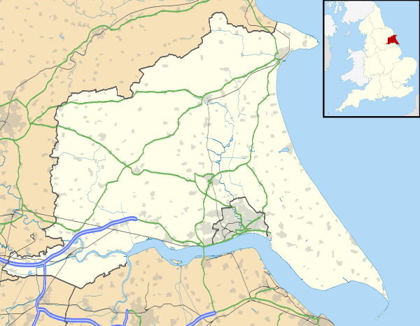 Aldbrough Location within the East Riding of Yorkshire | |
| Population | 1,269 (2011 census)[1] |
| OS grid reference | TA242386 |
| • London | 160 mi (260 km) S |
| Civil parish |
|
| Unitary authority | |
| Ceremonial county | |
| Region | |
| Country | England |
| Sovereign state | United Kingdom |
| Post town | HULL |
| Postcode district | HU11 |
| Dialling code | 01964 |
| Police | Humberside |
| Fire | Humberside |
| Ambulance | Yorkshire |
| UK Parliament | |
Civil parish
The civil parish is formed by the village of Aldbrough and the hamlets of East Newton, Etherdwick and Tansterne. According to the 2011 UK Census, Aldbrough parish had a population of 1,269,[1] a fall from the 2001 UK Census figure of 1,336.[2] The parish covers an area of 2,213.298 hectares (5,469.18 acres).[3]
A hamlet at Ringbrough (or Ringborough) dates to at least the 11th century.[4] By the 1850s it had been reduced to a single farm.[5] It was substantially expanded as a military installation during the Second World War, with the installation of gun emplacements, lookouts, and underground bunkers.[6] As of 2011 it is being destroyed by coastal erosion.[7][8]
In 1823 Aldbrough was a parish in the Wapentake and Liberty of Holderness. Population, which included the townships of East and West Newton, numbered 998. Occupations included fourteen farmers, two blacksmiths, one of whom was a farrier, a joiner who was also an auctioneer, four wheelwrights, four grocers, five shoemakers, four tailors, two butchers, a hairdresser, a common brewer, and the landlords of The George and The Bricklayer's Arms public houses. Also within the village were the parish vicar and the curate, three yeomen, two schoolmasters, two surgeons, a bailiff, an excise officer, a gentleman and a gentlewoman. Five carriers operated between Aldbrough and Hull twice weekly. The settlement of Fosham was 1 mile (1.6 km) to the south-east, its population included in Aldbrough. Fosham contained two farmers, and a once a week carrier to Hull.[9] There is also a Deserted Medieval Village called Bewick in the parish.[10]
Village
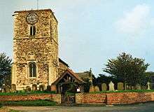
The Aldbrough Anglican parish church is dedicated to St Bartholomew. Dating from the second half of the 14th century, It is a Grade II* listed building.[11] On an interior wall (over a pillar of the south nave aisle) is a pre-conquest era sundial, bearing an inscription in mixed Anglo-Saxon and Old Norse: +VLF LET (?HET) AROERAN CYRICE FOR HANVM ⁊ FOR GVWARA SAVLA usually translated as "Ulf had this church built for his own sake and for Gunnvor's soul."[12]
Aldbrough has a public house and several small businesses within its boundaries, and is close to the seaside towns of Hornsea and Withernsea.
References
- UK Census (2011). "Local Area Report – Aldbrough Parish (1170211131)". Nomis. Office for National Statistics. Retrieved 14 February 2018.
- UK Census (2001). "Local Area Report – Aldbrough Parish (1543504178)". Nomis. Office for National Statistics. Retrieved 22 November 2018.
- "2001 Census Area Profile" (PDF). East Riding of Yorkshire Council. 2004. Archived from the original (PDF) on 10 September 2012. Retrieved 10 April 2013.
- Aldbrough in the Domesday Book. Retrieved 14 November 2012.
- Sheahan, J.J.; Whellan, T. (1856). "History of Holderness : Ringborough". History and topography of the city of York; the Ainsty wapentake; and the East riding of Yorkshire. 2. John Green (printers) (Beverley). p. 358. Retrieved 10 April 2013.
- Sanders, Ian. "Ringbrough". pillboxesuk.co.uk. Archived from the original on 28 September 2011. Retrieved 14 August 2011.
- Wood, Alexandra (6 August 2009). "The sea takes what the Nazis couldn't, as creeping coastal erosion eats away the east coast". Yorkshire Post. Retrieved 14 November 2012.
- Sources:
- Brigham, T.; Buglass, J.; George, R. (February 2008). "Rapid Coastal Zone Assessment : Yorkshire And Lincolnshire : Bempton to Donna Nook : English Heritage Project 3729 (Humber Archaeology Report No. 235)" (PDF). Humber Field Archaeology / English Heritage. Retrieved 2 February 2013.
- "Ringborough WWII Coast Artillery Battery". English Heritage. Retrieved 2 February 2013.
- "Ringbrough Coastal Battery, East Yorkshire (January 2000)". English Heritage. 2007. Archived from the original on 23 September 2012. Retrieved 2 February 2013.
- Baines, Edward (1823). History, Directory and Gazetteer of the County of York. pp. 150, 207.
- Historic England. "Monument No. 81730". PastScape. Retrieved 1 August 2018.
- Historic England. "Church of St Bartholomew (1083529)". National Heritage List for England. Retrieved 16 December 2011.
- Page, R. I. (1971). Clemoes, Peter; Hughes, Kathleen (eds.). How long did the Scandinavian language survive in England? The epigraphical evidence. England before the Conquest: Studies in primary sources presented to Dorothy Whitelock. Cambridge: Cambridge University Press. pp. 165–181.
- Gazetteer – A–Z of Towns Villages and Hamlets. East Riding of Yorkshire Council. 2006. p. 3.
External links

- "Aldbrough Parish Council". Aldbrough Parish Council. Retrieved 2 February 2013.
- Stubbs, Nick; Stubbs, Helen (2000). "Aldbrough: East Yorkshire". dspace.dial.pipex.com. Archived from the original on 9 July 2011. Retrieved 14 August 2011.
- "Landslides and coastal erosion at Aldbrough, East Riding of Yorkshire". British Geological Survey (BGS). Retrieved 2 February 2013.