Albion Park, New South Wales
Albion Park is a suburb situated in the Macquarie Valley in the City of Shellharbour, which is in turn one of the three local government areas that comprise the Wollongong Metropolitan Area, New South Wales, Australia. Although it is surrounded by a 'green belt' of farms, Albion Park had a population of 13,316 at the 2016 census.[1]
| Albion Park Illawarra, New South Wales | |||||||||||||||
|---|---|---|---|---|---|---|---|---|---|---|---|---|---|---|---|
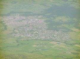
 An aerial picture of the suburb | |||||||||||||||
 Albion Park | |||||||||||||||
| Coordinates | 34°34′S 150°48′E | ||||||||||||||
| Population | 13,316 (2016 census)[1] | ||||||||||||||
| • Density | 1,387/km2 (3,593/sq mi) | ||||||||||||||
| Postcode(s) | 2527 | ||||||||||||||
| Area | 9.6 km2 (3.7 sq mi)[2] | ||||||||||||||
| Location |
| ||||||||||||||
| LGA(s) | City of Shellharbour | ||||||||||||||
| State electorate(s) | Kiama | ||||||||||||||
| Federal Division(s) | Whitlam | ||||||||||||||
| |||||||||||||||

The Illawarra escarpment is to the west, Dapto is to the north, Jamberoo is to the south and Shellharbour is to the east.
History
On 9 January 1821, the area around Albion Park was part of a grant of land of over 2000 acres given to Samuel Terry, a former convict who became one of the richest men in New South Wales.[3][4] Terry owned and operated the Terry's Meadows Esate, which operated as a cattle stud.[3][4] In 1834, Terry suffered from a stroke and died in 1838.[4]
The land was inherited by Samuel Terry's nephew, John Terry Hughes.[3] Hughes renamed the site to Albion Park.[3]
The township began to grow around the centre of the estate.[4] For European settlers, this had been a natural meeting place as it was where the road from Wollongong in the north crossed the road from the timber industry in Calderwood and Tongarra in the west as it ran out towards the port at Shellharbour.[4]
The arrival of the railway line in 1887, and the completion of the road through Macquarie Pass to the Southern Highlands, hastened the town’s growth.
Heritage listings
Albion Park has a number of heritage-listed sites, including:
Etymology
The term "Albion", is an ancient name of Great Britain.[6] The name was given to the area by John Terry Hughes after originally being known as the Terry's Meadow Estate.[3]
Population
According to the 2016 census of Population, there were 13,316 people in Albion Park.
- Aboriginal and Torres Strait Islander people made up 3.8% of the population.
- 82.8% of people were born in Australia. The next most common countries of birth were England 4.6%, Scotland 0.8%, Germany 0.8% and New Zealand 0.8%.
- 90.6% of people only spoke English at home.
- The most common responses for religion were Catholic 28.1%, No Religion 25.8% and Anglican 22.8%.[1]
Infrastructure
Trains
In order to avoid the highest parts of the ridge between Albion Park and Minnamurra, the railway needed to keep closer to the shore of Lake Illawarra. After the opening of Albion Park railway station two km to the east in 1887, a new town began to develop next to it, now known as Albion Park Rail.
Roads
The Illawarra Highway runs through Albion Park and joins the Princes Highway just north of the suburb. This road brings many people through the region. Albion Park is also the most direct link between Jamberoo Action Park and Sydney via the Princes Motorway and thus is directly on the route for those travelling south.
Education
There are currently 4 Primary Schools and 3 High Schools in Albion Park:
- Albion Park Public School
- Albion Park High School
- Mount Terry Public School
- St. Joseph's Catholic School, Albion Park
- St. Paul's Catholic Primary School, Albion Park
- Illawarra Christian School (Tongarra Campus)
- Tullimbar Primary school
Recreation
Albion Park is home to the Shellharbour Regional Sporting Complex, which consists of two all-weather hockey fields, several football (rugby league) fields, a multi-purpose indoor basketball stadium, a turf cricket / AFL field, an athletics field, a BMX track, a remote control car racing track,[7] and several tennis courts. A cycleway also courses its way through the Sporting Complex and links it to a polo field and a complex of soccer fields. Albion Park is also home to a Shellharbour Council Swimming Pool, which is open during the summer months and now costs a fee of $2.00 entry, to a pool paid for by the members of the town.
Clubs and pubs
Albion Park is home to three clubs where people go to eat and drink. They include:
- Albion Park Hotel
- Albion Park RSL
- Albion Park Bowls and Recreation Club
Sport
Albion Park is also home to various sporting teams such as:
- Albion Park-Oak Flats Eagles
- Albion Park Hockey Club
- Albion Park Bowls and Recreation Club
- Albion Park Cows Football Club
- Albion Park Cricket Club
- Albion Park White Eagles
- Albion Park Crows Junior AFL Club
Museums
Albion Park has the Tongarra Museum, which showcases the history of the region, and the Historical Aircraft Restoration Society Museum located at the Illawarra Regional Airport.
Commercial area
There is a small Vicinity Centres shopping complex in Albion Park. In 2009, the local Council started a program to revitalize the town centre and it has attracted more tourists to the town. The town is often referred to as Boganville by its community . The community wanted a big Ugg boot in the middle of the town .
References
- Australian Bureau of Statistics (27 June 2017). "Albion Park (State Suburb)". 2016 Census QuickStats. Retrieved 14 July 2017.

- "Map of Albion Park".
- "Albion Park | Shellharbour Local History". museum.shellharbour.nsw.gov.au. 9 December 2017. Retrieved 24 January 2020.
- "Samuel Terry | Shellharbour Local History". museum.shellharbour.nsw.gov.au. 9 December 2017. Retrieved 24 January 2020.
- "Toongla". New South Wales State Heritage Register. Office of Environment and Heritage. H00556. Retrieved 18 May 2018.
- Albion – Online Etymology Dictionary
- http://www.imccoffroad.com
External links
| Wikimedia Commons has media related to Albion Park, New South Wales. |