Albert, New South Wales
Albert is a town in the Central West region of New South Wales, Australia. The town is in the Lachlan Shire local government area, 481 kilometres (299 mi) west north west of the state capital, Sydney. At the 2016 census, Albert had a population of 81,[1] though Albert once had a population of 900.
| Albert New South Wales | |
|---|---|
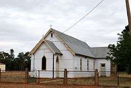 Albert Anglican Church | |
Albert | |
| Coordinates | 32°21′S 147°30′E |
| Population | 81 (2016 census)[1] |
| • Density | 0.1179/km2 (0.3055/sq mi) |
| Postcode(s) | 2873 |
| Area | 686.812 km2 (265.2 sq mi)[2] |
| Location | |
| LGA(s) | Lachlan Shire |
| State electorate(s) | Barwon |
| Federal Division(s) | Parkes |
Albert is on the Bogan Gate–Tottenham railway line.
Gallery
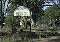 Edge of Albert village.
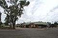 Rabbit Trap Hotel opposite Albert railway station.
gollark: I know it's not actually for security, but that is *not obvious*.
gollark: People *often* think "I'll set up ID filtering, that'll be secure".
gollark: What?
gollark: It's a fault of rednet seeming secure but not *being* secure.
gollark: It's not a "fault".
References
| Wikimedia Commons has media related to Albert, New South Wales. |
- Australian Bureau of Statistics (27 June 2017). "Albert (State Suburb)". 2016 Census QuickStats. Retrieved 1 February 2018.

- "Map of Albert".
This article is issued from Wikipedia. The text is licensed under Creative Commons - Attribution - Sharealike. Additional terms may apply for the media files.