Akole taluka
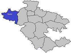
Akole taluka is a taluka in Ahmednagar district in Maharashtra State of India.[1]
Akole taluka | |
|---|---|
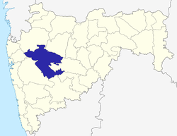
 Location of Akole in Ahmednagar district in Maharashtra | |
| Coordinates: 19°32′32.06″N 74°0′19.88″E | |
| Country | |
| State | Maharashtra |
| District | Ahmednagar district |
| Headquarters | Akole |
| Government | |
| • Lok Sabha constituency | Shirdi (Lok Sabha constituency) |
| • Assembly constituency | Akole (Vidhan Sabha constituency) |
| • MLA | Dr. Kiran Yamaji Lahamate |
| Area | |
| • Total | 1,505.0 km2 (581.1 sq mi) |
| Population (2001) | |
| • Total | 27,1,719 |
| • Density | 180/km2 (470/sq mi) |
| Demographics | |
| • Literacy rate | 59.15 % |
| • Sex ratio | 1.03 ♂/♀ |
| Rain | 1058 mm |
| Website | www |
Area
The table below shows area of the taluka by land type.[2]
| Type of Land | Area (km2) | % of Total Area |
|---|---|---|
| Agriculture | 987.12 | 65.59 |
| Forest | 416.98 | 27.7 |
| Other | 100.98 | 6.71 |
| Total | 1505.08 | 100 |
villages
There are around 191 villages in Akole taluka. For list of villages see Villages in Akole taluka.
Population
The table below shows population of the taluka by sex. The data is as per 2001 census.[3]
| Population | % of Total Population | Number of Literate | Literacy (% of Population) | |
|---|---|---|---|---|
| Male | 137617 | 50.65 | 95179 | 69.16 |
| Female | 134102 | 49.35 | 65555 | 48.88 |
| Total | 271719 | 100 | 160734 | 59.15 |
Rain Fall
The Table below details of rainfall from year 1981 to 2004.[4]
| Year | Rainfall (mm) |
|---|---|
| 1981 | 404 |
| 1982 | 396 |
| 1983 | 445 |
| 1984 | 374 |
| 1985 | 184 |
| 1986 | 244 |
| 1987 | 296 |
| 1988 | 734 |
| 1989 | 444 |
| 1990 | 503 |
| 1991 | 544 |
| 1992 | 404.5 |
| 1993 | 636.3 |
| 1994 | 509.8 |
| 1995 | 374 |
| 1996 | 620 |
| 1997 | 587 |
| 1998 | 814.5 |
| 1999 | 403 |
| 2000 | 439 |
| 2001 | 473 |
| 2002 | 445 |
| 2003 | 489 |
| 2004 | 1074 |
gollark: https://i.redd.it/r2lpbjnsf1521.png
gollark: (in the case of monopolies, it's almost certainly a better solution than regulating other stuff)
gollark: Regulation will fix everything!
gollark: See, the problem is is that corporations don't actually want to *sell* in free markets, but they do want to *buy* from them.
gollark: So THAT'S why Elon Musk is working on a Mars mission!
See also
- Talukas in Ahmednagar district
- Villages in Akole taluka
References
- "talukas in Ahmednagar district". Archived from the original on 29 September 2011. Retrieved 22 September 2010.
- "talukas geographic information". Archived from the original on 29 September 2011. Retrieved 22 September 2010.
- "talukas population information". Archived from the original on 29 September 2011. Retrieved 22 September 2010.
- "Rainfall information of Ahemadnagar district". Archived from the original on 8 December 2015. Retrieved 22 September 2010.
This article is issued from Wikipedia. The text is licensed under Creative Commons - Attribution - Sharealike. Additional terms may apply for the media files.
