Aikton
Aikton is a small village in the north of the English county of Cumbria. The nearest town is Wigton 3 miles away, and the nearest city is Carlisle at 8 miles. Aikton is located 5 1⁄2 miles (8.9 km) south of the Scottish border, in the centre of the Channel of the River Eden.[2] It is in the historic county of Cumberland.
| Aikton | |
|---|---|
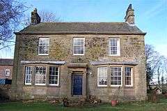 The Rectory, Aikton | |
 Aikton Location within Cumbria | |
| Area | 2.86 sq mi (7.4 km2) |
| Population | 467 (2011)[1] |
| • Density | 163/sq mi (63/km2) |
| OS grid reference | NY273534 |
| Civil parish |
|
| District | |
| Shire county | |
| Region | |
| Country | England |
| Sovereign state | United Kingdom |
| Post town | WIGTON |
| Postcode district | CA7 |
| Dialling code | 016973 |
| Police | Cumbria |
| Fire | Cumbria |
| Ambulance | North West |
| UK Parliament | |
| Website | Official website |
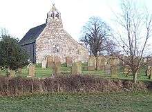
There is a pub, phonebox and postbox; but no shops. The local church, St Andrew's, is over 900 years old, and is one of the oldest in the region. Pevsner says that it has a "solid C12 w[est] front" and gives details of Norman and Early English Period work on the church."[3][4]
The village pub, the 'Aikton Inn', was constructed in the 18th century and is also used as a Bed and Breakfast facility.[5] Many houses in Aikton have views of the Lake District. The surrounding area is almost entirely farmland, containing cows usually.
Toponymy
'Aikton' "is OScand[inavian] 'eiki-tūn' or 'eik-tūn', 'oak tūn'.[6] So, the meaning is probably 'oak-tree hamlet'. ('OScand' is most likely to be Old Norse).
Parish
Aikton is a parish, which was formerly an ancient parish in the county of Cumberland.[7] It is five miles in length (from north to south) and two miles in breadth with an area of 6,156 acres – 1,829 of which was the village itself. This parish also includes the villages of Biglands, Gamelsby, Wampool and Wiggonby. Until the 16th century the area was terrorised by border raiders,[5] and the land formed one (demesne) of the two manors owned by the Burgh Barony, down to the death of Hugh de Morville in 1202. It had a population of 530 in 1688 and peaked at 856 in 1851.[7]
See also
References
- "Parish population Aikton 2011". Neighbourhood Statistics. Office for National Statistics. Retrieved 19 June 2015.
- Microsoft; Nokia (15 December 2018). "Aikton" (Map). Bing Maps. Microsoft. Retrieved 15 December 2018.
- Hyde, Matthew; Pevsner, Nikolaus (2010). Cumbria: Cumberland, Westmorland and Furness. The buildings of England. New Haven; London: Yale University Press. pp. xx, 775 p.90. ISBN 9780300126631.
- Historic England. "Church of St Andrew, Aikton (1327139)". National Heritage List for England. Retrieved 23 June 2012.
- Aikton Parish Website
- Armstrong, A. M.; Mawer, A.; Stenton, F. M.; Dickens, B. (1950–52). The place-names of Cumberland. Part 1. Cambridge: Cambridge University Press. p. 119.
- "Aikton". Cumbria County History Trust.