Aiguille Peak
Aiguille Peak is a peak located on the Canadian provincial boundary of Alberta and British Columbia in Banff National Park. It was named in 1915 by Arthur O. Wheeler.[1][2] "Aiguille" is French for "needle" and is also a mountaineering term for a sharp-ridged summit.[3][4]
| Aiguille Peak | |
|---|---|
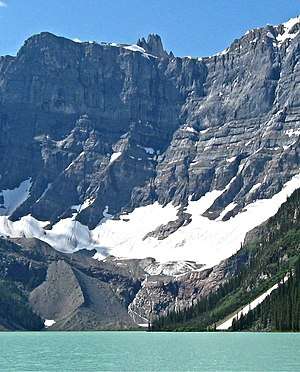 Aiguille Peak from Chephren Lake | |
| Highest point | |
| Elevation | 3,001 m (9,846 ft) [1] |
| Prominence | 206 m (676 ft) [2] |
| Coordinates | 51°48′16″N 116°40′11″W [2] |
| Geography | |
 Aiguille Peak Location in Alberta and British Columbia | |
| Location | Alberta / British Columbia, Canada |
| Parent range | Waputik Range |
| Topo map | NTS 82N/15 |
| Climbing | |
| First ascent | 1952 by Mr. and Mrs. J.D. Mendenhall[1] |
Geology
Aiguille Peak is composed of sedimentary rock laid down during the Precambrian to Jurassic periods. Formed in shallow seas, this sedimentary rock was pushed east and over the top of younger rock during the Laramide orogeny.[5]
Climate
Based on the Köppen climate classification, Aiguille Peak is located in a subarctic climate with cold, snowy winters, and mild summers.[6] Temperatures can drop below −20 °C with wind chill factors below −30 °C. Precipitation runoff from the peak drains east to the Mistaya River, or west into tributaries of the Blaeberry River.
See also
- List of peaks on the British Columbia-Alberta border
- List of mountains of Alberta
- Mountains of British Columbia
References
- "Aiguille Peak". PeakFinder.com. Retrieved Feb 8, 2010.
- "Aiguille Peak". Bivouac.com. Retrieved Feb 8, 2010.
- Boles, Glen W.; Laurilla, Roger W.; Putnam, William L. (2006). Canadian Mountain Place Names. Vancouver: Rocky Mountain Books. p. 24. ISBN 978-1-894765-79-4.
- Place-names of Alberta. Ottawa: Geographic Board of Canada. 1928. p. 10.
- Gadd, Ben (2008). "Geology of the Rocky Mountains and Columbias". Missing or empty
|url=(help) - Peel, M. C.; Finlayson, B. L. & McMahon, T. A. (2007). "Updated world map of the Köppen−Geiger climate classification". Hydrol. Earth Syst. Sci. 11: 1633–1644. ISSN 1027-5606.
External links
- Aiguille Peak close-up photo: Flickr