Agoo–Damortis Protected Landscape and Seascape
The Agoo–Damortis Protected Landscape and Seascape is located on the eastern side of Lingayen Gulf in southern La Union, Philippines. It was established in 2000 to protect 10,648.94 hectares (26,314.1 acres) of coastal area, including mangrove swamps, seagrass beds and stretches of fine black sand beaches.[1] It was first gazetted as a national park in 1965 and was known as the Agoo–Damortis National Seashore Park.[2] It covers approximately 30 kilometres (19 mi) of coastline of the Lingayen Gulf shared between the municipalities of Agoo, Santo Tomas and Rosario.
| Agoo–Damortis Protected Landscape and Seascape | |
|---|---|
IUCN category V (protected landscape/seascape) | |
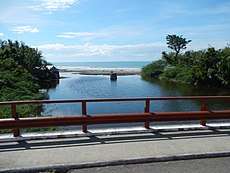 The coast of Damortis as seen from the Manila North Road | |
.svg.png) Location in the Philippines .svg.png) Agoo–Damortis Protected Landscape and Seascape (Philippines) | |
| Location | La Union, Philippines |
| Nearest city | San Fernando, La Union |
| Coordinates | 16°21′10″N 120°20′37″E |
| Area | 10,648.94 hectares (26,314.1 acres) |
| Established | June 19, 1965 (National park) April 23, 2000 (Protected landscape and seascape) |
| Governing body | Department of Environment and Natural Resources |
Description
The Agoo–Damortis park is located in 19 coastal barangays in southern La Union from Santa Rita in Agoo to the border with the province of Pangasinan. It is fed by three rivers, namely the Agoo, Bani and Cupang Rivers. The park includes the Santo Tomas Cove (also known as Damortis Cove) in Santo Tomas formed by a sand spit and bank on the western side which extends for 4 kilometres (2.5 mi) southwards in the sitio of Sungyot.[3] The 200-hectare (490-acre) cove is the location of large tracts of fishponds, as well as the Santo Tomas Anchorage and Fish Port. On the park's northern portion in Santa Rita is the 75-hectare (190-acre) Agoo Eco-Tourism World of Fun, an eco-tourism park developed by the local government, which contains a lagoon for fishing, kayaking and other water sport activities, and bicycle lanes along the park's seawall.[4]
The park is just 50 kilometres (31 mi) south of the provincial capital of San Fernando and 230 kilometres (140 mi) north of Manila.
Flora and fauna
Mangroves dominate the foreshore area which provide spawning and nursery grounds for fishes and crustaceans, and habitat for both local and migratory birds. Mangrove species in the area include: Avicennia spp.; Nipa fruticans; Pemphis acidula; Rhizophora apiculata; and Rhizophora mucronata.[5]
The slipmouth, goatfish, bream, snapper, grouper, tigerperch and rabbitfish are some species of fish in the area. Vast expanse of seagrass is also found in the area.
References
- "Proclamation No. 277, s. 2000". Official Gazette of the Republic of the Philippines. Retrieved 24 March 2016.
- "Republic Act No. 4570". The Corpus Juris. Retrieved 24 March 2016.
- "United States coast pilot, Philippine Islands". U.S. Coast and Geodetic Survey. Retrieved 24 March 2016.
- Rudio, Israel O. (2 September 2014). "Agoo boosts tourism". Provincial Government of La Union. Archived from the original on 6 April 2016. Retrieved 24 March 2016.
- "State of the Mangroves in La Union". Ateneo de Manila University. Retrieved 24 March 2016.