Adavale
Adavale is a rural town and locality in the Shire of Quilpie, Queensland, Australia.[2][3] In the 2016 census, Adavale had a population of 93 people.[4]
| Adavale Queensland | |||||||||||||||
|---|---|---|---|---|---|---|---|---|---|---|---|---|---|---|---|
 Adavale | |||||||||||||||
| Coordinates | 25°49′0″S 144°47′0″E | ||||||||||||||
| Population | 141 (2006 census)[1] | ||||||||||||||
| • Density | 0.006602/km2 (0.01710/sq mi) | ||||||||||||||
| Established | 1880 | ||||||||||||||
| Postcode(s) | 4474 | ||||||||||||||
| Area | 21,356.4 km2 (8,245.8 sq mi) | ||||||||||||||
| Location |
| ||||||||||||||
| LGA(s) | Shire of Quilpie | ||||||||||||||
| State electorate(s) | Warrego | ||||||||||||||
| Federal Division(s) | Maranoa | ||||||||||||||
| |||||||||||||||
Geography
Adavale is in South West Queensland, 931 kilometres (578 mi) west of the state capital, Brisbane.
History
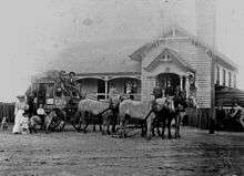
First established in 1880, the town is believed to have been named for the wife of the Queensland Surveyor-General, William Alcock Tully.[5] According to one tradition, the wife Ada lost her veil near the site, hence the original name of Ada's Veil.[6] The town was once a thriving centre but the diversion of the proposed railway line to the south — through what would later become the town of Quilpie — saw the community dwindle away.[7]
Adavale Post Office opened on 1 January 1881 and closed in 1991.[8]
From 1889 to 1930, Adavale was the seat of local government, initially the Adavale Division and later its successor the Shire of Adavale. After 1930, the shire was abolished and the Shire of Quilpie was established.
The Adavale State School opened in 1888 as a provisional school, becoming a state school in 1909. It closed in 1968.[9][10]
At the 2006 census, Adavale and the surrounding area had a population of 141,[1] with the town itself having an estimated population of around 15.[7]
Transport
The town is only accessible along a gravel road from Charleville in the east, Quilpie in the south and Blackall in the north.[7]
Geography
Between Adavale and Yaraka is Yapunyah waterhole.
References
- Australian Bureau of Statistics (25 October 2007). "Adavale (Quilpie Shire) (State Suburb)". 2006 Census QuickStats. Retrieved 11 November 2010.
- "Adavale - town in Shire of Quilpie (entry 104)". Queensland Place Names. Queensland Government. Retrieved 5 November 2019.
- "Adavale - locality in Shire of Quilpie (entry 42937)". Queensland Place Names. Queensland Government. Retrieved 5 November 2019.
- Australian Bureau of Statistics (27 June 2017). "Adavale (SSC)". 2016 Census QuickStats. Retrieved 20 October 2018.

- "Adavale". Quilpie Shire Council. Archived from the original on 19 July 2008. Retrieved 11 November 2010.
- Beatty, Bill (2 August 1947). "There's drama & tragedy in place names". The Sydney Morning Herald. p. 8. Retrieved 18 October 2015.
- "Adavale". Queensland's Outback. Tourism Queensland. Retrieved 11 November 2010.
- Premier Postal History. "Post Office List". Premier Postal Auctions. Retrieved 10 May 2014.
- Queensland Family History Society (2010), Queensland schools past and present (Version 1.01 ed.), Queensland Family History Society, ISBN 978-1-921171-26-0
- "Opening and closing dates of Queensland Schools". Queensland Government. Retrieved 18 April 2019.
External links
![]()
- "Adavale Shire". Queensland Places. Centre for the Government of Queensland, University of Queensland.