Abrams (CDP), Wisconsin
Abrams is an unincorporated community census-designated place located in the town of Abrams, Oconto County, Wisconsin, United States. Abrams is located near U.S. Route 41 and U.S. Route 141 8 miles (13 km) south-southeast of Oconto Falls. Abrams has a post office with ZIP code 54101.[4] As of the 2010 census, its population was 340.[5]
Abrams, Wisconsin | |
|---|---|
 Abrams, Wisconsin | |
| Coordinates: 44°46′45″N 88°03′35″W | |
| Country | United States |
| State | Wisconsin |
| County | Oconto |
| Area | |
| • Total | 0.82 sq mi (2.14 km2) |
| • Land | 0.82 sq mi (2.14 km2) |
| • Water | 0.00 sq mi (0.00 km2) |
| Elevation | 676 ft (206 m) |
| Population (2010) | |
| • Total | 2,310 |
| • Estimate (2016)[2] | N/A |
| Time zone | UTC-6 (Central (CST)) |
| • Summer (DST) | UTC-5 (CDT) |
| ZIP code | 54101 |
| Area code(s) | 920 |
| GNIS feature ID | 1560668[3] |
Notable people
- C. J. Greaves, off-road racer
- Johnny Greaves, off-road racer
- Lyle Lahey, cartoonist
- Pee Wee King, pioneer in the country and western music industry; wrote "Tennessee Waltz" and was inducted into the Country Music Hall of Fame in 1974
- Bob Wickman, former relief pitcher for the New York Yankees, Milwaukee Brewers, Cleveland Indians, Atlanta Braves, and Arizona Diamondbacks
- Arthur J. Whitcomb, Wisconsin State Representative and lawyer
gollark: My strategy this round was just to mess things up subtly so my entry *isn't even there to be guessed*.
gollark: (Coltrans knew this, but wanted to appear somewhat naÏve about C to obfuscate their entry)
gollark: How are my guesses to be submitted this round anyway?
gollark: Modern code is insufficiently idiomatic.
gollark: It shows you how idiomatic the code is based on its width.
References
- "2016 U.S. Gazetteer Files". United States Census Bureau. Retrieved Jul 19, 2017.
- "Population and Housing Unit Estimates". Retrieved June 9, 2017.
- U.S. Geological Survey Geographic Names Information System: Abrams (CDP), Wisconsin
- ZIP Code Lookup Archived June 15, 2011, at the Wayback Machine
- "U.S. Census website". U.S. Census Bureau. Retrieved 29 March 2011.
- "Census of Population and Housing". Census.gov. Retrieved June 4, 2016.
Municipalities and communities of Oconto County, Wisconsin, United States | ||
|---|---|---|
| Cities | 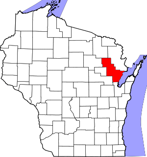 | |
| Villages | ||
| Towns | ||
| CDPs | ||
| Unincorporated communities | ||
| Indian reservation | ||
| Ghost town/neighborhood |
| |
| Footnotes | ‡This populated place also has portions in an adjacent county or counties | |
| Core city |  | |
|---|---|---|
| Largest municipalities over 10,000 in 2010 | ||
| Municipalities under 10,000 in 2010 | ||
| Counties | ||
*town ‡village °city §CDP †unincorporated community ^partial | ||
This article is issued from Wikipedia. The text is licensed under Creative Commons - Attribution - Sharealike. Additional terms may apply for the media files.