Aberdeen, Idaho
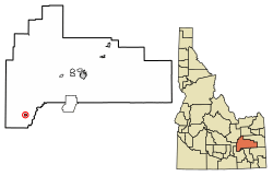
Aberdeen is a city in Bingham County, Idaho, United States. The community was named after Aberdeen, in Scotland.[4] The population was 1,994 at the 2010 census, up from 1,840 in 2000.[5]
Aberdeen | |
|---|---|
 Location of Aberdeen in Bingham County, Idaho. | |
 Aberdeen Location of Aberdeen in Bingham County, Idaho.  Aberdeen Aberdeen (the United States)  Aberdeen Aberdeen (North America) | |
| Coordinates: 42°56′36″N 112°50′22″W | |
| Country | United States |
| State | Idaho |
| County | Bingham |
| Area | |
| • Total | 1.03 sq mi (2.67 km2) |
| • Land | 1.03 sq mi (2.67 km2) |
| • Water | 0.00 sq mi (0.00 km2) |
| Elevation | 4,403 ft (1,342 m) |
| Population | |
| • Total | 1,994 |
| • Estimate (2019)[3] | 1,977 |
| • Density | 1,919.42/sq mi (741.34/km2) |
| Time zone | UTC-7 (Mountain (MST)) |
| • Summer (DST) | UTC-6 (MDT) |
| ZIP code | 83210 |
| Area code(s) | 208, 986 |
| FIPS code | 16-00100 |
| GNIS feature ID | 0396023 |
| Website | www |
Geography
Aberdeen is located at 42°56′36″N 112°50′22″W (42.943405, -112.839322),[6] at an elevation of 4,403 feet (1,342 m) above sea level. According to the United States Census Bureau, the city has a total area of 1.03 square miles (2.67 km2), all of it land.[7]
Climate
Aberdeen has a semi-arid steppe climate (BSk) according to the Köppen climate classification system.
| Climate data for Aberdeen Experiment Station (1914-2012) | |||||||||||||
|---|---|---|---|---|---|---|---|---|---|---|---|---|---|
| Month | Jan | Feb | Mar | Apr | May | Jun | Jul | Aug | Sep | Oct | Nov | Dec | Year |
| Record high °F (°C) | 56 (13) |
63 (17) |
76 (24) |
86 (30) |
96 (36) |
103 (39) |
104 (40) |
103 (39) |
99 (37) |
89 (32) |
76 (24) |
67 (19) |
104 (40) |
| Average high °F (°C) | 31.1 (−0.5) |
37 (3) |
47.1 (8.4) |
59.1 (15.1) |
68.7 (20.4) |
77.6 (25.3) |
87.9 (31.1) |
86.3 (30.2) |
76 (24) |
62.7 (17.1) |
45.7 (7.6) |
34.1 (1.2) |
59.4 (15.2) |
| Average low °F (°C) | 11 (−12) |
16 (−9) |
23.3 (−4.8) |
30 (−1) |
37.6 (3.1) |
44.3 (6.8) |
49.9 (9.9) |
47.3 (8.5) |
38.4 (3.6) |
29.6 (−1.3) |
21.5 (−5.8) |
13.8 (−10.1) |
30.2 (−1.0) |
| Record low °F (°C) | −42 (−41) |
−38 (−39) |
−24 (−31) |
−7 (−22) |
15 (−9) |
22 (−6) |
31 (−1) |
29 (−2) |
9 (−13) |
2 (−17) |
−16 (−27) |
−32 (−36) |
−42 (−41) |
| Average precipitation inches (mm) | 0.72 (18) |
0.63 (16) |
0.71 (18) |
0.85 (22) |
1.1 (28) |
0.9 (23) |
0.44 (11) |
0.47 (12) |
0.65 (17) |
0.82 (21) |
0.71 (18) |
0.79 (20) |
8.8 (220) |
| Average snowfall inches (cm) | 6.4 (16) |
4 (10) |
1.9 (4.8) |
1.3 (3.3) |
0.1 (0.25) |
0 (0) |
0 (0) |
0 (0) |
0 (0) |
0.5 (1.3) |
1.6 (4.1) |
5.2 (13) |
21 (53) |
| Average precipitation days | 8 | 6 | 6 | 6 | 7 | 5 | 3 | 4 | 4 | 5 | 6 | 7 | 67 |
| Source: WRCC[8] | |||||||||||||
Demographics
| Historical population | |||
|---|---|---|---|
| Census | Pop. | %± | |
| 1920 | 471 | — | |
| 1930 | 646 | 37.2% | |
| 1940 | 1,016 | 57.3% | |
| 1950 | 1,486 | 46.3% | |
| 1960 | 1,484 | −0.1% | |
| 1970 | 1,542 | 3.9% | |
| 1980 | 1,528 | −0.9% | |
| 1990 | 1,406 | −8.0% | |
| 2000 | 1,840 | 30.9% | |
| 2010 | 1,994 | 8.4% | |
| Est. 2019 | 1,977 | [3] | −0.9% |
| U.S. Decennial Census[9] | |||
2010 census
As of the census[2] of 2010, there were 1,994 people, 615 households, and 466 families residing in the city. The population density was 1,935.9 inhabitants per square mile (747.5/km2). There were 667 housing units at an average density of 647.6 per square mile (250.0/km2). The racial makeup of the city was 60.2% White, 0.1% African American, 0.7% Native American, 0.1% Asian, 37.5% from other races, and 1.5% from two or more races. Hispanic or Latino of any race were 54.1% of the population.
There were 615 households, of which 49.6% had children under the age of 18 living with them, 59.0% were married couples living together, 10.6% had a female householder with no husband present, 6.2% had a male householder with no wife present, and 24.2% were non-families. 20.0% of all households were made up of individuals, and 10.7% had someone living alone who was 65 years of age or older. The average household size was 3.24 and the average family size was 3.79.
The median age in the city was 28.1 years. 37.2% of residents were under the age of 18; 8.7% were between the ages of 18 and 24; 24.2% were from 25 to 44; 19.8% were from 45 to 64; and 10.1% were 65 years of age or older. The gender makeup of the city was 50.6% male and 49.4% female.
2000 census
As of the census[10] of 2000, there were 1,840 people, 603 households, and 435 families residing in the city. The population density was 1,807.9 people per square mile (696.5/km2). There were 654 housing units at an average density of 642.6 per square mile (247.6/km2). The racial makeup of the city was 66.30% White, 0.11% African American, 0.71% Native American, 0.33% Asian, 0.05% Pacific Islander, 28.91% from other races, and 3.59% from two or more races. Hispanic or Latino of any race were 39.29% of the population.
There were 603 households, out of which 41.0% had children under the age of 18 living with them, 60.7% were married couples living together, 7.5% had a female householder with no husband present, and 27.7% were non-families. 26.7% of all households were made up of individuals, and 14.6% had someone living alone who was 65 years of age or older. The average household size was 3.05 and the average family size was 3.75.
In the city, the population was spread out, with 38.3% under the age of 18, 7.2% from 18 to 24, 25.4% from 25 to 44, 17.1% from 45 to 64, and 12.0% who were 65 years of age or older. The median age was 29 years. For every 100 females, there were 95.7 males. For every 100 females age 18 and over, there were 96.2 males.
The median income for a household in the city was $28,625, and the median income for a family was $31,393. Males had a median income of $27,537 versus $19,531 for females. The per capita income for the city was $10,907. About 14.9% of families and 20.5% of the population were below the poverty line, including 27.0% of those under age 18 and 14.2% of those age 65 or over.
Education
Aberdeen Public Schools are part of the Aberdeen School District #58. Schools located in the district include Aberdeen Elementary School, Aberdeen Middle School and Aberdeen High School.
The University of Idaho's Aberdeen Research and Extension Center is located near the town.[11]
C.J. Ward is the Superintendent of Schools.[12]
Transportation
Airport
Aberdeen Municipal Airport is a city-owned public-use airport located two nautical miles (3.7 km) southwest of the central business district of Aberdeen.[13]
Pocatello Regional Transit operates a shuttle bus from Aberdeen to Pocatello three times on Weekdays, and twice on Saturdays and Sundays.
References
- "2019 U.S. Gazetteer Files". United States Census Bureau. Retrieved July 9, 2020.
- "U.S. Census website". United States Census Bureau. Retrieved 2012-12-18.
- "Population and Housing Unit Estimates". United States Census Bureau. May 24, 2020. Retrieved May 27, 2020.
- The Utah Genealogical and Historical Magazine, Volumes 9-10. 1918. p. 8.
- Spokesman-Review Archived 2016-03-04 at the Wayback Machine - 2010 census - Aberdeen, Idaho - accessed 2011-12-23
- "US Gazetteer files: 2010, 2000, and 1990". United States Census Bureau. 2011-02-12. Retrieved 2011-04-23.
- "US Gazetteer files 2010". United States Census Bureau. Archived from the original on 2012-01-25. Retrieved 2012-12-18.
- "ABERDEEN EXP STN, IDAHO (100010)". Western Regional Climate Center. Retrieved December 10, 2015.
- "Census of Population and Housing". Census.gov. Retrieved June 4, 2015.
- "U.S. Census website". United States Census Bureau. Retrieved 2008-01-31.
- https://www.uidaho.edu/cals/aberdeen-research-and-extension-center
- "Aberdeen School District #58". Aberdeen School District #58. Archived from the original on 2012-06-20. Retrieved 2012-06-24.
- FAA Airport Master Record for U36 (Form 5010 PDF). Federal Aviation Administration. Effective 3 June 2010.