2018 Papua New Guinea earthquake
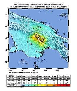
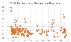
The Papua New Guinea earthquake was a magnitude 7.5 earthquake that occurred in the Hela Province of Papua New Guinea on 26 February 2018 (25 February UTC), at 3:44 a.m. local time (25 February, 17:44 UTC). The earthquake's epicenter was 10 kilometres (6.2 mi) west of the town of Komo. The maximum felt intensity was IX (Violent) on the Mercalli intensity scale.[1] A total of 160 people were killed and many others were injured.[2][3] An aftershock of M6.0 killed 11 people on 4 March,[4] while another aftershock of M6.7 occurred at 00:13 local time on 7 March,[5] killing at least 25 more.[6] A 6.3 aftershock killed another 4 people on 7 April, more than a month after the first tremors hit the area.
 USGS shakemap for the event | |
 | |
| UTC time | 2018-02-25 17:44:44 |
|---|---|
| ISC event | 615000068 |
| USGS-ANSS | ComCat |
| Local date | 26 February 2018 |
| Local time | 03:44:44 |
| Magnitude | 7.5 Mw |
| Depth | 23.4 km (14.5 mi) |
| Epicenter | 6.070°S 142.754°E |
| Type | Thrust fault |
| Areas affected | Papua New Guinea, Indonesia |
| Total damage | Building and infrastructure damage, sinkholes, landslides |
| Max. intensity | IX (Violent) |
| Landslides | Yes |
| Aftershocks | 6.7 Mw 6.2 Mw 6.0 Mw 6.0 Mw 6.0 Mw |
| Casualties | 160 dead (main shock) 11 dead (6.0 aftershock on 4 March) 25 dead (6.7 aftershock on 6 March) 4 dead (6.3 aftershock on 7 April) |
Tectonic setting
Papua New Guinea lies within the complex zone of collision between the Australian Plate and the Pacific Plate, which converge at a rate of 107 mm per year at the earthquake's location.[1] The Papuan fold and thrust belt, which is responsible for the mountainous New Guinea Highlands, forms the boundary between the Stable Platform area to the south and the Mobile Belt to the north. The Stable Platform consists of little deformed continental crust of the Australian Plate. The Mobile Belt consists of a series of arc terranes and continental fragments previously accreted to the Australian Plate. Current convergence across the fold and thrust belt are estimated at up to 15 mm per year. The thrusting is thick-skinned in type, involving reverse reactivation of much older extensional faults.[7]
Earthquake
The main shock struck at a depth of 23.4 km below the northern slopes of Mt. Sisa, and was followed by a 5.5 Mb aftershock less than 30 minutes later.[1] The Geohazards Management Division in Port Moresby characterized it as "typical for the Papuan fold and thrust belt".[8]
Aftershocks
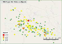
There have been more than 270 aftershocks reported by USGS in total, 68 of which were above magnitude 5, and 6 of which were above magnitude 6.
 |
 |
| No. | Date (UTC) | Magnitude | Depth (km) | Remarks |
|---|---|---|---|---|
| 1 | 2018-02-25 17:44 | 7.5 | 25.2 | Main shock |
| 2 | 2018-02-25 18:11 | 5.7 | 10.0 | |
| 3 | 2018-02-25 18:15 | 5.0 | 10.0 | |
| 3 | 2018-02-25 18:26 | 5.4 | 35.0 | |
| 4 | 2018-02-25 18:47 | 5.0 | 35.0 | |
| 5 | 2018-02-25 19:40 | 5.3 | 35.0 | |
| 6 | 2018-02-25 20:17 | 5.2 | 35.0 | |
| 7 | 2018-02-25 21:11 | 5.0 | 35.0 | |
| 8 | 2018-02-25 21:47 | 5.2 | 16.6 | |
| 9 | 2018-02-25 22:19 | 5.0 | 35.0 | |
| 10 | 2018-02-25 22:28 | 5.0 | 35.0 | |
| 11 | 2018-02-25 22:57 | 5.0 | 35.0 | |
| 12 | 2018-02-26 02:25 | 5.0 | 35.0 | |
| 13 | 2018-02-26 03:10 | 5.0 | 35.0 | |
| 14 | 2018-02-26 03:12 | 5.2 | 35.0 | |
| 15 | 2018-02-26 05:28 | 5.0 | 10.8 | |
| 16 | 2018-02-26 07:01 | 5.1 | 35.0 | |
| 17 | 2018-02-26 08:26 | 6.0 | 23.6 | |
| 18 | 2018-02-26 09:19 | 5.0 | 60.3 | |
| 19 | 2018-02-26 11:56 | 5.7 | 13.3 | |
| 20 | 2018-02-26 12:29 | 5.0 | 40.0 | |
| 21 | 2018-02-26 12:34 | 5.2 | 26.7 | |
| 22 | 2018-02-26 15:17 | 6.2 | 13.8 | |
| 23 | 2018-02-26 17:41 | 5.1 | 10.0 | |
| 24 | 2018-02-26 18:28 | 5.5 | 31.0 | |
| 25 | 2018-02-26 19:21 | 5.1 | 21.2 | |
| 26 | 2018-02-26 21:52 | 5.0 | 10.0 | |
| 27 | 2018-02-27 00:08 | 5.1 | 10.0 | |
| 28 | 2018-02-27 00:55 | 5.0 | 10.0 | |
| 29 | 2018-02-27 02:15 | 5.2 | 10.0 | |
| 30 | 2018-02-27 06:19 | 5.6 | 10.0 | |
| 31 | 2018-02-27 07:19 | 5.2 | 10.0 | |
| 32 | 2018-02-27 13:58 | 5.0 | 14.7 | |
| 33 | 2018-02-27 14:11 | 5.0 | 14.4 | |
| 34 | 2018-02-27 16:19 | 5.2 | 10.0 | |
| 35 | 2018-02-27 20:11 | 5.2 | 10.0 | |
| 36 | 2018-02-28 02:45 | 6.1 | 16.0 | |
| 37 | 2018-02-28 05:22 | 5.2 | 10.0 | |
| 38 | 2018-02-28 14:00 | 5.0 | 10.0 | |
| 39 | 2018-03-02 00:57 | 5.0 | 10.0 | |
| 40 | 2018-03-02 03:01 | 5.6 | 28.7 | |
| 41 | 2018-03-02 07:59 | 5.1 | 10.0 | |
| 42 | 2018-03-02 21:30 | 5.1 | 41.9 | |
| 43 | 2018-03-04 11:44 | 5.1 | 10.0 | |
| 44 | 2018-03-04 12:40 | 5.4 | 22.6 | |
| 45 | 2018-03-04 14:33 | 5.8 | 6.0 | |
| 46 | 2018-03-04 19:56 | 6.0 | 10.0 | 11 killed |
| 47 | 2018-03-06 02:52 | 5.0 | 10.0 | |
| 48 | 2013-03-06 03:26 | 5.3 | 10.0 | |
| 49 | 2018-03-06 14:13 | 6.7 | 22.9 | 25 killed |
| 50 | 2018-03-06 14:40 | 5.1 | 10.0 | |
| 51 | 2018-03-06 14:50 | 5.2 | 10.0 | |
| 52 | 2018-03-06 15:35 | 5.2 | 10.0 | |
| 53 | 2018-03-06 17:32 | 5.0 | 16.6 | |
| 54 | 2018-03-06 19:18 | 5.1 | 35.9 | |
| 55 | 2018-03-07 18:11 | 5.0 | 10.0 | |
| 56 | 2018-03-08 03:33 | 5.3 | 10.0 | |
| 57 | 2018-03-08 04:59 | 5.0 | 50.4 | |
| 58 | 2018-03-15 18:58 | 5.0 | 10.0 | |
| 59 | 2018-03-23 11:52 | 5.3 | 59.5 | |
| 60 | 2018-03-28 18:50 | 5.0 | 10.0 | |
| 61 | 2018-03-29 16:06 | 5.0 | 10.0 | |
| 62 | 2018-04-07 02:56 | 5.3 | 10.0 | |
| 63 | 2018-04-07 05:48 | 6.3 | 10.0 | 4 killed |
| 64 | 2018-04-09 02:18 | 5.1 | 10.0 | |
| 65 | 2018-04-13 03:57 | 5.0 | 12.9 | |
| 66 | 2018-04-16 06:09 | 5.1 | 10.0 | |
| 67 | 2018-05-05 20:24 | 5.0 | 10.0 | |
| 69 | 2018-06-29 01:55 | 5.3 | 52.5 |
Aftermath
Damage
On the morning of 26 February, ExxonMobil announced that they would temporarily shut down the Hides gas field conditioning plant, situated about 8 kilometres (5.0 mi) from the epicenter, in order to assess damage.[10] Officials later confirmed that all of the staff were "safe and accounted for",[11] while the administration buildings, living quarters, and mess hall had all sustained damage. The company was planning on evacuating all non-essential personnel.[12] Flights into the Komo airfield were temporarily suspended until the runway could be surveyed.[8] Sinkholes and landslides were reported across the affected areas, with electricity supplies also being disrupted.[12] On 10 March, ExxonMobil officials announced that the Hides facility will not be operational for at least 8 weeks, a significant economic loss for the country.[13]
Papua New Guinea's... largest oil and gas exploration and development company Oil Search also announced it would shut down production in the Southern Highlands until it could ensure the safety of its employees.[12] The Porgera Gold Mine suffered damage to its gas and electricity infrastructure,[12] while landslips blocked the access road to the Ok Tedi Mine and damaged parts of the highway between Tabubil and Kiunga in the Western Province.[14]
A week after the quake, International Red Cross and Red Crescent Movement officials estimated that at least 7,000 people had their homes destroyed or damaged, and 150,000 people were in urgent need of emergency supplies, with food and clean water among the biggest concerns. Lack of road access and landslides were hampering deliveries in the area.[15] By 7 March the number of displaced people had risen to 17,000, with continuing problems due to damaged roads and communication difficulties.[6]
The first UNDAC situational overview was released on 10 March, prepared in collaboration with local and international agencies. Over 544,000 people were reported to be affected by the quake, with half of them being targeted for assistance, and more than 26,000 displaced across the western parts of the country.[16]
On 15 March, nearly three weeks after the earthquake, UNICEF estimated that 275,000 people were in need of urgent humanitarian assistance, including 125,000 children.[17]
Indonesia
The quake and its aftershocks caused panic in Jayapura, the capital of Indonesia's Papua province.[8] The country's National Board for Disaster Management later confirmed that several buildings were damaged in the Boven Digoel Regency, including a mosque, a military post, and a district office.[18]
Casualties
A total of 160 people were reported to have been killed, while many others were badly injured.[2][3] Hela Province had at least 80 confirmed deaths, while 45 casualties were reported from the Southern Highlands Province.[17]
On 4 March, a M6.0 aftershock killed 11 people after a landslide buried the small village of Huya.[4] A further 25 people were reported killed by a M6.7 aftershock on 7 March.[6][3] A M6.3 aftershock on 7 April caused more damage, and four people were killed when houses collapsed in Tari.[19]
Response
The government of Papua New Guinea dispatched disaster assessment teams to parts of the Southern Highlands and Hela provinces following the earthquake. Members of the Papua New Guinea Defence Force were also mobilised to assist with the delivery of supplies to affected people, as well as the restoration of services and infrastructure.[12] A state of emergency was declared on 1 March for the provinces of Hela, Southern Highlands, Enga and Western, together with a promise of 450 million kina (about 138 million US$) to help deal with the aftermath of the quake.[20] On 8 March, the country's Commerce and Industry Minister Wera Mori estimated that reconstruction will cost at least 600 million kina (about 185 million US$).[21] In addition to the four provinces under a state of emergency, Gulf Province was also discovered to be seriously affected in the quake's aftermath.[16]
The Australian government promised $AU 200,000 in aid and sent a C-130 Hercules aircraft for aerial surveys.[22] The first shipment of supplies arrived at Moro Airport on 3 March.[23] Four days later the country pledged a further 1,000,000 US$ in support of vulnerable women and children in the earthquake-affected areas, as well as three CH-47 Chinook helicopters and additional Australian Defence Force personnel.[24]
The New Zealand government sent two Lockheed C-130 Hercules planes carrying hygiene kits, shelter supplies, water containers and tarpaulins.[3][25] The government of China donated over 2.8 million kina (about 880,000 US$) in the weeks after the disaster.[26] On 8 March 40 electricity generators were delivered from Israel.[27][28][29]
The Red Cross released $221,000 in funds and announced it would send first aid, water, mosquito nets and shelters to the stricken areas.[22] ExxonMobil donated $1,000,000 to relief efforts, and allowed the government to use its experts, resources and helicopters in the recovery process,[30] while Santos Limited released a total of $1,200,000 to the Hela Provincial Hospital and aid agencies working in Papua New Guinea.[15] Bank South Pacific donated 1 million kina (about 310,000 US$) to the emergency relief and reconstruction fund.[31]
By 16 March, the total amount of cash donations had reached 150 million kina (about 46 million US$), with the government announcing it had already committed about one third of them to humanitarian aid and road reconstruction.[32]
References
- "M.7.5 - 81km SW of Porgera, Papua New Guinea". United States Geological Survey. Retrieved 25 February 2018.
- "Pray for those suffering - Post Courier". postcourier.com.pg. Retrieved 28 March 2018.
- Packham, Colin. "At least 18 killed as second earthquake strikes Papua New Guinea". Thomson Reuters Foundation News. Retrieved 7 March 2018.
- "Strong aftershocks rock PNG leaving 11 people dead". ABC News. 5 March 2018. Retrieved 5 March 2018.
- "M 6.7 - 112km SW of Porgera, Papua New Guinea". United States Geological Survey. Retrieved 6 March 2018.
- "At least 25 killed in PNG aftershocks". Courier Mail. 7 March 2018. Retrieved 7 March 2018.
- Mahoney L.; Hill K.; McLaren S.; Hanani A. (July 2017). "Complex fold and thrust belt structural styles: Examples from the Greater Juha area of the Papuan Fold and Thrust Belt, Papua New Guinea". Journal of Structural Geology. 100: 98–119. Bibcode:2017JSG...100...98M. doi:10.1016/j.jsg.2017.05.010.
- "Major quake cuts communications, halts oil and gas operations in Papua New Guinea". Reuters. 26 February 2018. Retrieved 26 February 2018.
- "Search Results". USGS.
- "ExxonMobil shuts PNG gas conditioning plant to assess quake damage". Reuters. 25 February 2018. Retrieved 26 February 2018.
- "PNG troops respond to major 7.5-magnitude quake as aftershocks hit". Channel New Asia. Retrieved 26 February 2018.
- "Quake Rocks Shela, SHP". The Papua New Guinea Post-Courier. Retrieved 26 February 2018.
- "Papua New Guinea quake: An invisible disaster which could change life forever". BBC. 10 March 2018. Retrieved 11 March 2018.
- "Landslip Blocks Mine's Access Road". The Papua New Guinea Post-Courier. 27 February 2018. Retrieved 27 February 2018.
- "Week after Papua New Guinea quake, nearly 150,000 people in urgent need of aid". Reuters. 4 March 2018. Retrieved 4 March 2018.
- "Papua New Guinea: Highlands Earthquake Situation Report No. 1 (as of 10 March 2018)". ReliefWeb. 10 March 2018. Retrieved 11 March 2018.
- "Papua New Guinea earthquake: death toll rises as disease threat grows". Guardian. Retrieved 15 March 2018.
- "Powerful 7.5-magnitude earthquake rattles remote Papua New Guinea". The Hindu. 26 February 2018. Retrieved 26 February 2018.
- "Four confirmed dead after weekend quake in PNG". Radio New Zealand. 9 April 2018. Retrieved 9 April 2018.
- Gorethy, Kenneth (1 March 2018). "State of Emergency Declared". Papua and New Guinea Post-Courier. Retrieved 1 March 2018.
- "Damages To Cost K600M". Papua New Guinea Post Courier. 8 March 2018. Retrieved 8 March 2018.
- "PNG declares state of emergency after deadly quake strikes rugged highlands". Reuters. 2 March 2018. Retrieved 4 March 2018.
- "PNG Aus Partnership Delivers Supplies Via Royal Australian Air Force". Papua New Guinea Post Courier. 3 March 2018. Retrieved 4 March 2018.
- "Further Humanitarian Support To PNG". Papua New Guinea Post Courier. 7 March 2018. Retrieved 7 March 2018.
- "New Zealand commits initial $500k to Papua New Guinea". Radio New Zealand. 5 March 2018. Retrieved 7 March 2018.
- "Condolences from President Xi". Papua New Guinea Post Courier. 12 March 2018. Retrieved 12 March 2018.
- "Israel Provides Generators to Earthquake-Devastated Papua New Guinea".
- "Israel to Provide Generators and Other Support to Earthquake Affected Communities in Papua New Guinea".
- "Israel donates generators to Papua after earthquake".
- "Help is slow to come, nearly a week after PNG quake". Radio New Zealand. 3 March 2018. Retrieved 3 March 2018.
- "BSP Gives K1m For Restoration". Papua New Guinea Post Courier. 12 March 2018. Retrieved 12 March 2018.
- "Cash Donations Total K150m". Papua New Guinea Post Courier. 16 March 2018. Retrieved 18 March 2018.
External links
- The International Seismological Centre has a bibliography and/or authoritative data for this event.
- ReliefWeb's main page for this event..