1977 North Indian Ocean cyclone season
The 1977 North Indian Ocean cyclone season was part of the annual cycle of tropical cyclone formation. The season has no official bounds but cyclones tend to form between April and December. These dates conventionally delimit the period of each year when most tropical cyclones form in the northern Indian Ocean. There are two main seas in the North Indian Ocean—the Bay of Bengal to the east of the Indian subcontinent and the Arabian Sea to the west of India. The official Regional Specialized Meteorological Centre in this basin is the India Meteorological Department (IMD), while the Joint Typhoon Warning Center (JTWC) releases unofficial advisories. An average of five tropical cyclones form in the North Indian Ocean every season with peaks in May and November.[1] Cyclones occurring between the meridians 45°E and 100°E are included in the season by the IMD.[2]
| 1977 North Indian Ocean cyclone season | |
|---|---|
 Season summary map | |
| Seasonal boundaries | |
| First system formed | May 9, 1977 |
| Last system dissipated | November 23, 1977 |
| Strongest storm | |
| Name | Andhra Pradesh |
| • Maximum winds | 250 km/h (155 mph) (3-minute sustained) |
| • Lowest pressure | 919 hPa (mbar) |
| Seasonal statistics | |
| Depressions | 18 |
| Cyclonic storms | 5 |
| Severe cyclonic storms | 5 |
| Super cyclonic storms | 1 (record high, tied with 1989, 1990, 1991, 1999, 2007,2019, and 2020) |
| Total fatalities | Unknown |
| Total damage | Unknown |
| Related articles | |
Systems
Tropical Storm One (01B)
| Tropical storm (SSHWS) | |
 | |
| Duration | May 9 – May 13 |
|---|---|
| Peak intensity | 110 km/h (70 mph) (1-min) |
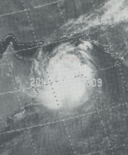
Tropical Storm Two (02A)
| Tropical storm (SSHWS) | |
  | |
| Duration | June 9 – June 13 |
|---|---|
| Peak intensity | 110 km/h (70 mph) (1-min) |
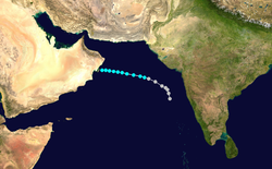
On June 9, a tropical disturbance was noted off the west coast of India in the Arabian Sea. The system moved northward, followed by a northwest turn on June 10 while the system intensified into a tropical storm. It curved toward the west, and the JTWC reported the cyclone as reaching peak winds of 70 mph (110 km/h) on June 11. The JTWC issued the final advisory at 0800 UTC on June 13 as the storm was making landfall on Masirah Island.[3] The Oman Department of Meteorology reported the storm as being much stronger than the JTWC, with sustained winds of 105 mph (165 km/h) with gusts to 140 mph (230 km/h).[4] Shortly after striking Masirah, the storm moved ashore mainland Oman, causing rapid weakening to tropical depression status. The system dissipated on June 14 after crossing into southeastern Saudi Arabia.[3]
The cyclone was the strongest on record to make landfall on the Arabian Peninsula, until Cyclone Gonu surpassed it in 2007.[5][6] Overall, the cyclone caused 105 deaths and 48 injuries,[7] and 50,000 people were left homeless.[8]
Tropical Storm Three (03A)
| Tropical storm (SSHWS) | |
 | |
| Duration | October 19 – October 22 |
|---|---|
| Peak intensity | 65 km/h (40 mph) (1-min) |
Tropical Storm Four (04B)
| Tropical storm (SSHWS) | |
| |
| Duration | October 27 – November 4 |
|---|---|
| Peak intensity | 75 km/h (45 mph) (1-min) |
Cyclone Five (05B)
| Category 3 tropical cyclone (SSHWS) | |
| |
| Duration | November 9 – November 23 |
|---|---|
| Peak intensity | 205 km/h (125 mph) (1-min) |
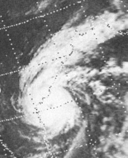
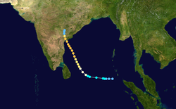
Cyclone Six (06B)
| Extremely severe cyclonic storm (IMD) | |
| Category 4 tropical cyclone (SSHWS) | |
  | |
| Duration | November 14 – November 20 |
|---|---|
| Peak intensity | 205 km/h (125 mph) (3-min) 919 hPa (mbar) |
The monsoon trough spawned a tropical depression on November 14. It tracked westward, becoming a tropical storm on the November 15 and a cyclone on November 16. A break in the subtropical ridge pulled the cyclone northward, where it slowly strengthened to a peak of 125 mph winds. It hit the Andhra Pradesh coastline on November 19 at that intensity, and dissipated the next day. Strong winds, heavy flooding, and storm surge of 5 meters high killed 10,000 people,[9] left hundreds of thousands homeless, killed 40,000 cattle.[10] and destroyed 40% of India's food grains.
See also
- List of North Indian Ocean cyclone seasons
- 1977 Atlantic hurricane season
- 1977 Pacific hurricane season
- 1977 Pacific typhoon season
- Australian cyclone seasons: 1976–77, 1977–78
- South Pacific cyclone seasons: 1976–77, 1977–78
- South-West Indian Ocean cyclone seasons: 1976–77, 1977–78
References
- "Frequently Asked Questions: What is the annual frequency of Cyclones over the Indian Seas? What is its intra-annual variation?". Indian Meteorological Department. 2012. Archived from the original on May 21, 2015. Retrieved June 8, 2012.
- "Bulletins Issued by Regional Specialized Meteorological Centre (RSMC) - Tropical Cyclones, New Delhi" (PDF). India Meteorological Department. May 25, 2009. Archived from the original (PDF) on 2012-04-12. Retrieved July 16, 2012.
- Joint Typhoon Warning Center Staff (1977). "Annual Typhoon Report" (PDF). United States Military. Archived from the original (PDF) on June 7, 2011. Retrieved 2010-12-18.
- Yassine Charabi (2009). Indian Ocean: Tropical Cyclones and Climate Change. Springer. Retrieved 18 December 2010.
- NASA (2007). "Rare Tropical Cyclone Churns in Arabian Sea". Retrieved 2010-12-18.
- Staff Writer (2007-06-06). "Weakening cyclone Gonu hits Oman". Agence French-Presse. Archived from the original on 21 November 2010. Retrieved 2010-12-18.
- Office of U.S. Foreign Disaster Assistance (August 1993). "Significant Data on Major Disasters Worldwide 1990–present" (PDF). Retrieved 2009-03-25.
- Staff Writer (1977-06-20). "50 Killed in Oman Hurricane". The Sydney herald. AAP-Reuters. Retrieved 2010-12-18.
- "Natural catastrophes and man-made disasters in 2008: North America and Asia suffer heavy losses" (PDF). Swiss Reinsurance Company Ltd. 21 January 2009. p. 38. Retrieved 23 May 2017.
- Dipankar C. Patnaik & N. Sivagnanam (November 2007). "DISASTER VULNERABILITY OF COASTAL STATES: A Short Case Study of Orissa, India". Social Science Research Network. p. 4. SSRN 1074845. Missing or empty
|url=(help)