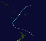
1977–78 South Pacific cyclone season
| 1977–78 South Pacific cyclone season | |
|---|---|
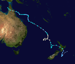
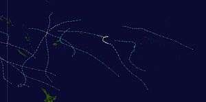 Season summary map | |
| Seasonal boundaries | |
| First system formed | November 24, 1977 |
| Last system dissipated | April 22, 1978 |
| Strongest storm | |
| Name | Bob and Charles |
| • Maximum winds | 155 km/h (100 mph) (10-minute sustained) |
| • Lowest pressure | 945 hPa (mbar) |
| Seasonal statistics | |
| Total depressions | 8 |
| Tropical cyclones | 8 |
| Severe tropical cyclones | 3 |
| Total fatalities | Unknown |
| Total damage | Unknown |
| Related articles | |
Systems
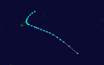
Tropical Cyclone Steve
| Category 2 tropical cyclone (Australian scale) | |
| Category 1 tropical cyclone (SSHWS) | |
 | |
| Duration | November 24 – December 4 |
|---|---|
| Peak intensity | 110 km/h (70 mph) (10-min) 965 hPa (mbar) |
Tropical Cyclone Tessa
| Category 1 tropical cyclone (Australian scale) | |
| Tropical storm (SSHWS) | |
 | |
| Duration | December 5 – December 11 |
|---|---|
| Peak intensity | 75 km/h (45 mph) (10-min) 990 hPa (mbar) |
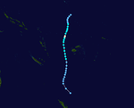
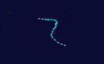
Tropical Cyclone Anne
| Category 2 tropical cyclone (Australian scale) | |
| Tropical storm (SSHWS) | |
 | |
| Duration | December 23 – December 31 |
|---|---|
| Peak intensity | 100 km/h (65 mph) (10-min) 980 hPa (mbar) |
For several days during the week building up to Christmas 1977, a tropical disturbance persisted about 925 km (575 mi) to the northeast of Fiji and to the northwest of Samoa.[1] A distinct cyclonic circulation subsequently started to develop during December 23, while it was located about 740 km (460 mi) to the northeast of Vanua Levu. Over the next day the system moved south-westwards and passed within 75 km (45 mi) of Futuna, before it was named Anne by the FMS during December 24, as satellite pictures showed that a tropical cyclone was developing. During December 25, the winds were indirectly estimated to be off gale-force, as it passed south-westwards through the Fijian Islands.
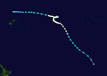
Severe Tropical Cyclone Bob
| Category 3 severe tropical cyclone (Australian scale) | |
| Category 1 tropical cyclone (SSHWS) | |
 | |
| Duration | December 31 – January 12 |
|---|---|
| Peak intensity | 155 km/h (100 mph) (10-min) 945 hPa (mbar) |
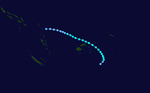
Severe Tropical Cyclone Charles
| Category 3 severe tropical cyclone (Australian scale) | |
| Category 1 tropical cyclone (SSHWS) | |
 | |
| Duration | February 13 – March 1 |
|---|---|
| Peak intensity | 155 km/h (100 mph) (10-min) 945 hPa (mbar) |
Tropical Cyclone Diana
| Category 2 tropical cyclone (Australian scale) | |
| Tropical storm (SSHWS) | |
 | |
| Duration | February 15 – February 22 |
|---|---|
| Peak intensity | 95 km/h (60 mph) (10-min) 980 hPa (mbar) |
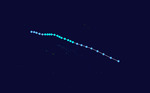
Tropical Cyclone Ernie
| Category 2 tropical cyclone (Australian scale) | |
| Tropical storm (SSHWS) | |
 | |
| Duration | February 17 – February 23 |
|---|---|
| Peak intensity | 100 km/h (65 mph) (10-min) 980 hPa (mbar) |
During February 17, the FMS started to monitor a tropical depression that had developed, about 560 km (350 mi) to the northwest of Udu Point in Fiji.[1] During that day, the system deepened as it moved south-eastwards towards Fiji before the FMS named it Ernie.[1]
Severe Tropical Cyclone Hal
| Category 3 severe tropical cyclone (Australian scale) | |
| Category 1 tropical cyclone (SSHWS) | |
 | |
| Duration | April 13 – April 22 |
|---|---|
| Peak intensity | 130 km/h (80 mph) (10-min) 965 hPa (mbar) |
See also
References
- Krishna, Ram (January 4, 1981). Publication No. 2: Tropical Cyclones in Fiji: November 1969 – April 1980 (Report). Fiji Meteorological Service. pp. 3–5.