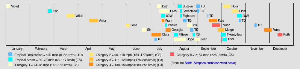
1955 Pacific typhoon season
The 1955 Pacific typhoon season has no official bounds; it ran year-round in 1955, but most tropical cyclones tend to form in the northwestern Pacific Ocean between June and December. These dates conventionally delimit the period of each year when most tropical cyclones form in the northwestern Pacific Ocean.
| 1955 Pacific typhoon season | |
|---|---|
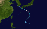
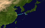
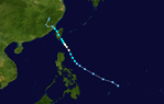
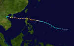
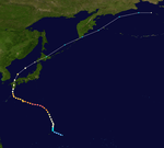
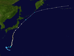
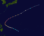
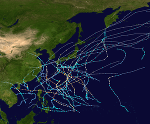 Season summary map | |
| Seasonal boundaries | |
| First system formed | January 1, 1955 |
| Last system dissipated | December 18, 1955 |
| Strongest storm | |
| Name | Clara |
| • Maximum winds | 285 km/h (180 mph) (1-minute sustained) |
| • Lowest pressure | 919 hPa (mbar) |
| Seasonal statistics | |
| Total depressions | 39 |
| Total storms | 31 |
| Typhoons | 20 |
| Super typhoons | 4 (unofficial) |
| Total fatalities | Unknown |
| Total damage | Unknown |
| Related articles | |
The scope of this article is limited to the Pacific Ocean, north of the equator and west of the international date line. Storms that form east of the date line and north of the equator are called hurricanes; see 1955 Pacific hurricane season. Tropical Storms formed in the entire west Pacific basin were assigned a name by the Fleet Weather Center on Guam.
Systems
The rest of the storms, such as unnumbered and unnamed tropical depressions and storms, are only classified by the CMA while the JMA is sometimes rare before the 1960s - 1970s.
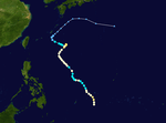
Typhoon Violet
| Category 1 typhoon (SSHWS) | |
  | |
| Duration | January 1 – January 6 |
|---|---|
| Peak intensity | 140 km/h (85 mph) (1-min) 995 hPa (mbar) |
JMA Tropical Storm Two
| Tropical storm (JMA) | |
 | |
| Duration | February 23 – February 28 |
|---|---|
| Peak intensity | 85 km/h (50 mph) (10-min) 995 hPa (mbar) |
Typhoon Wilda
| Category 2 typhoon (SSHWS) | |
 | |
| Duration | March 21 – March 29 |
|---|---|
| Peak intensity | 165 km/h (105 mph) (1-min) 985 hPa (mbar) |
Forming in an area full of islands, Wilda moved up into the open ocean where it reached typhoon strength. Shortly after, Wilda peaked in intensity as a lower-end category 2 cyclone. Wilda soon made a turn and began to weaken. Soon enough, Wilda had weakened under typhoon strength and dissipated on March 29.
Typhoon Anita
| Category 3 typhoon (SSHWS) | |
 | |
| Duration | April 17 – April 28 |
|---|---|
| Peak intensity | 185 km/h (115 mph) (1-min) 977 hPa (mbar) |
Anita formed as a tropical depression on April 17. Anita entered a phase of warm waters, and it rapidly intensified to a category 1 typhoon and even a category 2 typhoon later. Anita encountered on a phase of cool waters, and as a result, it gradually weakened. Anita but re-intensified into a category 1 typhoon on April 20. However, it weakened again on April 22 but again re-intensified to a category 1 and even a category 2 typhoon later. Anita reached its peak intensity as a category 3 typhoon. Anita encountered a strong wind shear and because of this, Anita rapidly weakened to a tropical storm. Anita weakened to a tropical depression on April 25. Later, Anita loses its identity and dissipated.
Typhoon Billie
| Category 3 typhoon (SSHWS) | |
 | |
| Duration | June 2 – June 7 |
|---|---|
| Peak intensity | 185 km/h (115 mph) (1-min) 988 hPa (mbar) |
JMA Typhoon Six
| Category 1 typhoon (SSHWS) | |
 | |
| Duration | June 23 – June 28 |
|---|---|
| Peak intensity | 130 km/h (80 mph) (1-min) 982 hPa (mbar) |
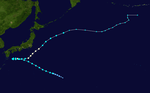
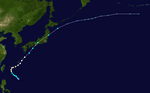
Typhoon Clara
| Category 4 super typhoon (SSHWS) | |
 | |
| Duration | July 5 – July 17 |
|---|---|
| Peak intensity | 250 km/h (155 mph) (1-min) 919 hPa (mbar) |
Typhoon Dot
| Category 1 typhoon (SSHWS) | |
 | |
| Duration | July 12 – July 17 |
|---|---|
| Peak intensity | 130 km/h (80 mph) (1-min) 995 hPa (mbar) |
Typhoon Ellen
| Category 1 typhoon (SSHWS) | |
 | |
| Duration | July 15 – July 27 |
|---|---|
| Peak intensity | 130 km/h (80 mph) (1-min) 960 hPa (mbar) |
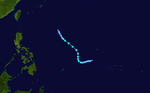
Tropical Storm 09W
| Tropical storm (SSHWS) | |
 | |
| Duration | July 17 – July 23 |
|---|---|
| Peak intensity | 95 km/h (60 mph) (1-min) 990 hPa (mbar) |
Typhoon Fran
| Category 4 typhoon (SSHWS) | |
 | |
| Duration | July 18 – July 21 |
|---|---|
| Peak intensity | 215 km/h (130 mph) (1-min) 930 hPa (mbar) |
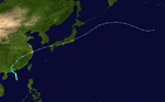
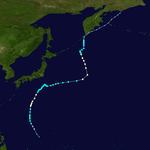
On July 18, a tropical depression formed southeast of Japan. It entered a phase of favorable environments and was soon upgraded into a tropical storm and named Fran. Fran then moved into a favorable environment and Fran was upgraded into a category 1 typhoon. Intensification occurred and Fran intensified from a category 1 to 4 typhoon and reached its peak intensity. After peaking in intensity, unfavorable environments made Fran to start a weakening trend. On July 20, Fran weakened to a category 2 typhoon and later weakened to a category 1 typhoon and even as a strong tropical storm. On July 21 of noon, Fran weakened to a tropical depression, and soon encountered with strong wind shear and dissipated. Fran became extratropical on July 21, before moving further to the east and dissipated on July 23.
JMA Tropical Storm Twelve
| Tropical storm (JMA) | |
 | |
| Duration | July 22 – July 24 |
|---|---|
| Peak intensity | 65 km/h (40 mph) (10-min) 990 hPa (mbar) |
Typhoon Georgia
| Category 4 typhoon (SSHWS) | |
 | |
| Duration | July 23 – July 29 |
|---|---|
| Peak intensity | 215 km/h (130 mph) (1-min) 945 hPa (mbar) |
JMA Tropical Storm Fifteen
| Tropical storm (JMA) | |
 | |
| Duration | August 2 – August 7 |
|---|---|
| Peak intensity | 75 km/h (45 mph) (10-min) 995 hPa (mbar) |
Typhoon Hope
| Category 1 typhoon (SSHWS) | |
 | |
| Duration | August 2 – August 17 |
|---|---|
| Peak intensity | 140 km/h (85 mph) (1-min) 975 hPa (mbar) |
A tropical depression formed east of Philippines on August 2. It intensified to a tropical storm in the next day and named Hope. Hope intensified into a category 1 hurricane while at the south of Japan. It weakened to a tropical storm and the storm turned to the north and intensified into a category 1 again.
It was downgraded to a tropical storm and turned northeast before it slowed down. Hope became extratropical on August 17. Shortly after, the remnants hit the south of Kamchatka Peninsula and dissipated.
JMA Tropical Storm Sixteen
| Tropical storm (JMA) | |
 | |
| Duration | August 5 – August 14 |
|---|---|
| Peak intensity | 85 km/h (50 mph) (10-min) 985 hPa (mbar) |
JMA Tropical Storm Seventeen
| Tropical storm (JMA) | |
 | |
| Duration | August 10 – August 12 |
|---|---|
| Peak intensity | 75 km/h (45 mph) (10-min) 1000 hPa (mbar) |
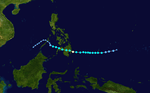
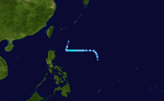
17W is a short tropical storm that never affected land.
JMA Tropical Storm Eighteen
| Tropical storm (SSHWS) | |
 | |
| Duration | August 10 – August 12 |
|---|---|
| Peak intensity | 65 km/h (40 mph) (1-min) 999 hPa (mbar) |
Typhoon Iris
| Category 1 typhoon (SSHWS) | |
 | |
| Duration | August 19 – August 25 |
|---|---|
| Peak intensity | 150 km/h (90 mph) (1-min) 965 hPa (mbar) |
Typhoon Joan
| Category 1 typhoon (SSHWS) | |
 | |
| Duration | August 29 – September 4 |
|---|---|
| Peak intensity | 150 km/h (90 mph) (1-min) 968 hPa (mbar) |
Typhoon Kate
| Category 4 super typhoon (SSHWS) | |
 | |
| Duration | September 16 – September 26 |
|---|---|
| Peak intensity | 250 km/h (155 mph) (1-min) 930 hPa (mbar) |
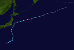
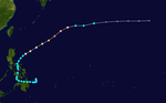
Typhoon Louise
| Category 5 super typhoon (SSHWS) | |
  | |
| Duration | September 20 – September 30 |
|---|---|
| Peak intensity | 280 km/h (175 mph) (1-min) 930 hPa (mbar) |
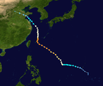
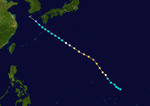
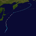
Louise formed on September 20 as a weak tropical depression. It intensified into a tropical storm and even a typhoon later. Wind shear quickly decreased and sea surface temperatures began to rise and Louise rapidly intensified into a category 5 super typhoon. However, the process of eyewall replacement cycle caused Louise to weaken. Louise weakened to a category 2 typhoon and it started to affect the Kyųshū island of Japan and even weakened to a category 1 typhoon and affected Japan. Louise dissipated on September 30. On Kyūshū island, 54 people were killed and 14 went missing.
Typhoon Marge
| Category 3 typhoon (SSHWS) | |
 | |
| Duration | September 27 – October 5 |
|---|---|
| Peak intensity | 185 km/h (115 mph) (1-min) 964 hPa (mbar) |
JMA Tropical Storm Twenty-four
| Tropical storm (JMA) | |
 | |
| Duration | October 1 – October 7 |
|---|---|
| Peak intensity | 75 km/h (45 mph) (10-min) 1003 hPa (mbar) |
Tropical Storm 17W
| Tropical storm (SSHWS) | |
 | |
| Duration | October 3 – October 8 |
|---|---|
| Peak intensity | 75 km/h (45 mph) (1-min) 998 hPa (mbar) |
Typhoon Nora
| Category 2 typhoon (SSHWS) | |
 | |
| Duration | October 4 – October 13 |
|---|---|
| Peak intensity | 175 km/h (110 mph) (1-min) 955 hPa (mbar) |
Typhoon Opal
| Category 2 typhoon (SSHWS) | |
 | |
| Duration | October 15 – October 23 |
|---|---|
| Peak intensity | 155 km/h (100 mph) (1-min) 982 hPa (mbar) |
Tropical Storm 20W
| Tropical storm (SSHWS) | |
 | |
| Duration | October 22 – October 27 |
|---|---|
| Peak intensity | 75 km/h (45 mph) (1-min) 1004 hPa (mbar) |
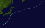
Typhoon Patsy
| Category 4 super typhoon (SSHWS) | |
 | |
| Duration | November 25 – December 4 |
|---|---|
| Peak intensity | 250 km/h (155 mph) (1-min) 940 hPa (mbar) |
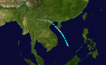
Patsy started on its life as a tropical depression on November 25. It hit Philippines as a tropical storm. It moved out of area before intensifying into Typhoon Patsy. Patsy reached its peak intensity before undergoing an eyewall replacement cycle and started to weaken.
Storm names
The following names listed here are names of the 1955 Pacific Typhoon Season.
|
|
|
|
|
See also
- 1955 Pacific hurricane season
- 1955 Atlantic hurricane season
- Pre-1980 North Indian Ocean cyclone seasons
- Pre-1970 Southern Hemisphere tropical cyclones