1883 Atlantic hurricane season
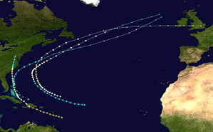
The 1883 Atlantic hurricane season ran through the summer and the first half of fall in 1883. This is the period of each year when most tropical cyclones form in the Atlantic basin. In the 1883 Atlantic season there was one tropical storm, one Category 1 hurricane, and two major hurricanes (Category 3+). However, in the absence of modern satellite monitoring and remote-sensing technologies, only storms that affected populated land areas or encountered ships at sea were recorded, so the actual total could be higher. An undercount bias of zero to six tropical cyclones per year between 1851 and 1885 and zero to four per year between 1886 and 1910 has been estimated.[1]
| 1883 Atlantic hurricane season | |
|---|---|
 Season summary map | |
| Seasonal boundaries | |
| First system formed | August 18, 1883 |
| Last system dissipated | October 24, 1883 |
| Strongest storm | |
| Name | Two |
| • Maximum winds | 125 mph (205 km/h) (1-minute sustained) |
| • Lowest pressure | 948 mbar (hPa; 27.99 inHg) |
| Seasonal statistics | |
| Total storms | 4 |
| Hurricanes | 3 |
| Major hurricanes (Cat. 3+) | 2 |
| Total fatalities | 236 |
| Total damage | Unknown |
Season summary
The Atlantic hurricane database (HURDAT)[2] recognizes four tropical cyclones for the 1883 season. In 1883 there was one tropical storm, one Category 1 hurricane and two major hurricanes in the Atlantic basin. Due to the inactivity of the season, there were no storms in June, July or November. Both Hurricane One and Hurricane Two were active in the Western Atlantic throughout the second half of August. Although Hurricane One was the only storm of the year not to make a landfall, it did cause 80 deaths among seafarers off Newfoundland. Hurricane Three was a major hurricane that was first seen in the Lesser Antilles and travelled north to eventually dissipate over Virginia. It caused 106 deaths in the Bahamas and North Carolina. The last known cyclone was a tropical storm active in October between the Bahamas and the coast of North Carolina.
Timeline

Systems
Hurricane One
| Category 1 hurricane (SSHWS) | |
 | |
| Duration | August 18 – August 27 |
|---|---|
| Peak intensity | 90 mph (150 km/h) (1-min) 975 mbar (hPa) |
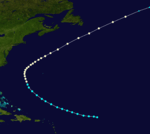
A tropical storm was first seen on August 18 in the tropical Atlantic. It moved to the west-northwest, becoming a hurricane before turning to the northeast. It moved past Newfoundland on August 26.[2] The hurricane caused 80 deaths from swells in the Newfoundland area.[3]
Hurricane Two
| Category 3 hurricane (SSHWS) | |
 | |
| Duration | August 24 – August 30 |
|---|---|
| Peak intensity | 125 mph (205 km/h) (1-min) ≤ 948 mbar (hPa) |
A hurricane was first seen on August 24 to the northeast of the Lesser Antilles. Resembling a Cape Verde-type hurricane, it moved to the northwest, and reached major hurricane status on the 28th. On the 29th, the hurricane peaked at 130 mph (210 km/h), but turned to the northeast where unfavorable conditions caused it to weaken. It passed south of the Canadian Maritimes, and became extratropical on August 30 to the east of Newfoundland. The extratropical storm persisted until September 2 when it lost its identity over East Anglia.
Hurricane Three
| Category 3 hurricane (SSHWS) | |
 | |
| Duration | September 4 – September 13 |
|---|---|
| Peak intensity | 125 mph (205 km/h) (1-min) 955 mbar (hPa) |
The Bahamas-North Carolina Hurricane of 1883
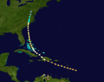
A major hurricane moved through the Lesser Antilles on September 4. It crossed Hispaniola, weakening to a minimal hurricane. It restrengthened as it passed the Bahamas, and struck North Carolina as a Category 2 hurricane on the 11th. It dissipated over Virginia on September 13.[2] Across North Carolina trees were uprooted and fences, light buildings, telegraph and telephone lines blown down . Several vessels were wrecked off the North Carolina coast and flooding occurred along the Cape Fear River.[4] In Virginia the rains from this storm helped end a summer-long drought but any benefit was minimal, as the peanut crop had already failed from the lack of rain. At Nottoway, Virginia, heavy rain from the cyclone may have led to a train with 10 freight cars derailing.[5] Overall the hurricane caused 106 deaths in the Bahamas and North Carolina.[3]
Tropical Storm Four
| Tropical storm (SSHWS) | |
 | |
| Duration | October 22 – October 24 |
|---|---|
| Peak intensity | 60 mph (95 km/h) (1-min) 983 mbar (hPa) |
A tropical storm formed on October 22 over the Bahamas. It moved to the north, then turned to the northeast while off the North Carolina coastline. The storm peaked at 60 mph (97 km/h) on October 24 before becoming extratropical the same night. As an extratropical cyclone it strengthened to an 80 mph (130 km/h) storm before dissipating.[2]
See also
- List of notable tropical cyclones
- Atlantic hurricane season
- Tropical cyclone observation
- Atlantic hurricane reanalysis project
References
- Landsea, C. W. (2004). "The Atlantic hurricane database re-analysis project: Documentation for the 1851–1910 alterations and additions to the HURDAT database". In Murname, R. J.; Liu, K.-B. (eds.). Hurricanes and Typhoons: Past, Present and Future. New York: Columbia University Press. pp. 177–221. ISBN 0-231-12388-4.
- Hurricane Research Division (2008). "Easy to Read HURDAT". National Oceanic and Atmospheric Administration. Retrieved January 23, 2010.
- Edward N. Rappaport & Jose Fernandez-Partagas (1996). "The Deadliest Atlantic Tropical Cyclones, 1492–1996: Cyclones with 25+ deaths". National Hurricane Center. Retrieved 2011-03-14.
- Hudgins,James E. (2000). "Tropical cyclones affecting North Carolina since 1586 - An Historical Perspective" (PDF). National Oceanic and Atmospheric Administration.
- David Roth & Hugh Cobb. "Virginia Hurricane History". National Oceanic and Atmospheric Administration. Archived from the original on January 8, 2008. Retrieved January 14, 2008.