List of the most isolated major summits of North America
The following sortable table comprises the 200 most topographically isolated mountain peaks of greater North America[1] with at least 500 meters (1640 feet) of topographic prominence.[2]
The summit of a mountain or hill may be measured in three principal ways:
- The topographic elevation of a summit measures the height of the summit above a geodetic sea level.[3][4]
- The topographic prominence of a summit is a measure of how high the summit rises above its surroundings.[5][4]
- The topographic isolation (or radius of dominance) of a summit measures how far the summit lies from its nearest point of equal elevation.[6]
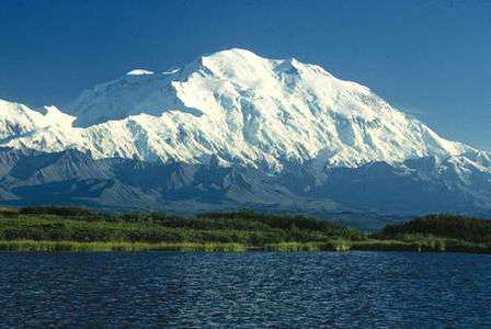
Denali is one of only three summits on Earth with more than 6000 kilometers (3728 miles) of topographic isolation. Four major summits of greater North America exceed 2000 kilometers (1243 miles), eight exceed 1000 kilometers (621.4 miles), 35 exceed 500 kilometers (310.7 miles), 107 exceed 200 kilometers (124.3 miles), 230 exceed 100 kilometers (62.14 miles), and 413 exceed 50 kilometers (31.07 miles) of topographic isolation.
Most isolated major summits
Of these 200 most isolated major summits of North America, 83 are located in the United States (excluding four in Hawaiʻi), 48 in Canada, 28 in México, 19 in Greenland, four in Honduras, two in Guatemala, two in Cuba, two in Haiti, two in Panamá, two in Nicaragua, and one each in the Dominican Republic, Costa Rica, Guadeloupe, Puerto Rico, Jamaica, Saint Kitts and Nevis, Saint Vincent and the Grenadines, Trinidad and Tobago, Belize, Grenada, and the British Virgin Islands. Two of these peaks lie on the Canada-United States border and one lies on the Nicaragua-Honduras border.
Gallery

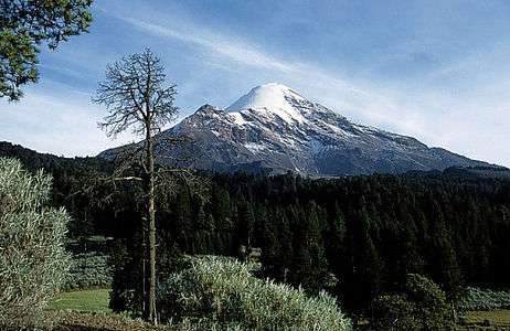 3. Pico de Orizaba is the highest summit of México.
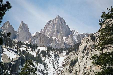 4. Mount Whitney highest summit of the Sierra Nevada and California.
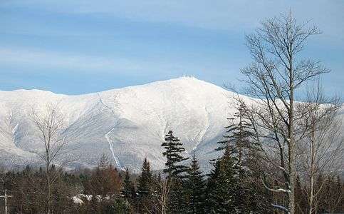 6. Mount Washington is the highest summit of the White Mountains and New Hampshire.
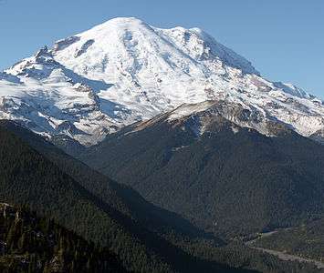

 10. Chirripó Grande is the highest summit of Costa Rica.


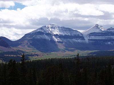 72. Kings Peak is the highest summit of the Uinta Range and Utah.
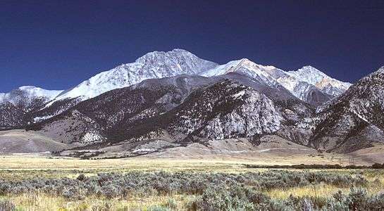
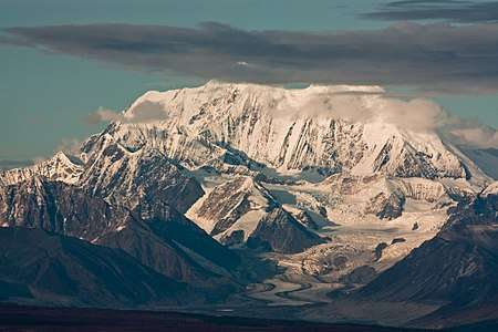 104. Mount Hayes is the highest summit of the eastern Alaska Range.

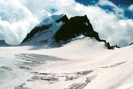
 145. Popocatépetl is the second highest summit of México.
 156. Granite Peak is the highest summit of the Beartooth Range and Montana.
 197. Nevado de Toluca is the fourth highest summit of México.
See also
- North America
- Geography of North America
- Geology of North America
- Lists of mountain peaks of North America
- List of mountain peaks of North America
- List of the highest major summits of North America
- List of the most prominent summits of North America
- List of the ultra-prominent summits of North America
- List of the most isolated major summits of North America
- List of extreme summits of North America
- List of mountain peaks of Greenland
- List of mountain peaks of Canada
- List of mountain peaks of the Rocky Mountains
- List of mountain peaks of the United States
- List of mountain peaks of México
- List of mountain peaks of Central America
- List of mountain peaks of the Caribbean
- Category:Mountains of North America
- List of mountain peaks of North America
- Physical geography
Notes
- The summit of Denali is the highest point of the Alaska Range, the State of Alaska, the United States of America, and greater North America. Denali is the third most topographically prominent and third most topographically isolated summit on Earth after Mount Everest and Aconcagua.
- The summit of Gunnbjørn Fjeld is the highest point of the Island of Greenland, Kalaallit Nunaat, the Kingdom of Denmark, and the entire Arctic.
- Gunnbjørn Fjeld is the easternmost summit of its elevation in greater North America.
- The summit of Pico de Orizaba is the highest point of Estado Libre y Soberano de Puebla, Estado Libre y Soberano de Veracruz de Ignacio de la Llave, and all of México.
- The summit of Mount Whitney is the highest point of the Sierra Nevada, the State of California, and the contiguous United States.
- Mount Whitney is the southernmost and easternmost summit of its elevation in United States.
- The summit of Mount Mitchell is the highest point of the Appalachian Mountains, the State of North Carolina, and the eastern United States.
- Mount Mitchell is the easternmost 2000-meter (6562-foot) summit of the United States.
- The elevation of Mount Mitchell includes an adjustment of +0.025 m (0.08 ft) from NGVD 29 to NAVD 88.
- The summit of Mount Washington is the highest point of the White Mountains, the State of New Hampshire, and the northeastern United States.
- Mount Washington is the easternmost ultra-prominent summit of the United States.
- The elevation of Mount Washington includes an adjustment of +0.02 m (0.07 ft) from NGVD 29 to NAVD 88.
- The summit of Mount Rainier is the highest point of the Cascade Range and the U.S. State of Washington. Mount Rainier is the most prominent summit in the contiguous United States and the fourth most prominent in North America.
- The elevation of Mount Rainier includes an adjustment of +1.914 m (6.28 ft) from NGVD 29 to NAVD 88.
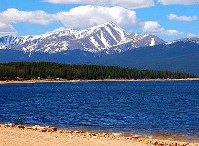
- The summit of Mount Elbert is the highest point of the U.S. State of Colorado, the Rocky Mountains of North America, and the entire Mississippi River drainage basin.
- The summit of Pico Duarte is the highest point of the Dominican Republic, the Island of Hispaniola, and all islands of the Caribbean Sea.
- The summit of Chirripó Grande is the highest point of the Republic of Costa Rica.
- Chirripó Grande is the southernmost and easternmost summit of its elevation in Central America and greater North America.
- The summit of Shishaldin Volcano is the highest point of Unimak Island and the Aleutian Islands.
- Shishaldin Volcano is the westernmost summit of its elevation in Alaska, the United States, and greater North America.
- The summit of Barbeau Peak is the highest point of Ellesmere Island and Nunavut of Canada.
- Barbeau Peak is the northernmost ultra-prominent summit of Canada and greater North America.
- The summit of Mount Caubvick is the highest point of the Torngat Mountains, the Province of Newfoundland and Labrador, and all of eastern Canada.
- The summit of Volcán Tajumulco is the highest point of the Sierra de las Nubes, the Republic of Guatemala, and all of Central America.
- Volcán Tajumulco is the southernmost and easternmost 4000-meter (13,123-foot) summit of greater North America.
- The summit of La Grande Soufrière is the highest point of île de Basse-Terre and the French Région Guadeloupe.
- La Grande Soufrière is the southernmost and easternmost summit of its elevation in the Caribbean.
- The summit of Tanaga Volcano is the highest point of Tanaga Island and the Andreanof Islands.
- Tanaga Volcano is the westernmost summit of its elevation in Alaska, the United States, and greater North America.
- The apex of Avannaarsua is the northernmost and westernmost summit of its elevation in Greenland.
- The summit of Mount Isto is the highest point of the Brooks Range.
- Mount Isto is the northernmost ultra-prominent summit of Alaska and the United States.
- The summit of Cerro San Rafael is the highest point of Sierra Madre Oriental and Estado Libre y Soberano de Coahuila.
- Cerro San Rafael is the northernmost summit of its elevation in México.
- The summit of Mathiassen Mountain is the highest point of Southampton Island.
- The summit of Mount Logan is the highest point of the Saint Elias Mountains, Yukon, and all of Canada.
- The summit of Angilaaq Mountain is the highest point of Bylot Island.
- The summit of Signal Hill is the highest point of the Ouachita Mountains and the U.S. State of Arkansas.
- The elevation of Signal Hill includes an adjustment of +0.075 m (0.25 ft) from NGVD 29 to NAVD 88.
- The summit of Mount Odin is the highest point of Baffin Island.
- Mount Odin is the easternmost summit of its elevation in Canada.
- The summit of Cerro El Potosí is the highest point of Estado Libre y Soberano de Nuevo León.
- The summit of Mount Waddington is the highest point of the Coast Mountains.
- Mount Waddington is the southernmost and easternmost 4000-meter (13,123-foot) summit of Canada.
- The summit of Keele Peak is the highest point of the Mackenzie Mountains.
- Keele Peak is the northernmost summit of its elevation in Canada.
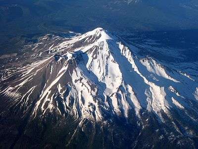
- The summit of Mount Shasta is the highest point of the southern Cascade Range.
- Mealy Mountains High Point is the easternmost 1000-meter (3281-foot) summit of Canada.
- The apex of Peary Land is the northernmost summit of its elevation of Greenland and greater North America.
- The summit of The Cabox is the highest point of the island of Newfoundland.
- The Cabox is the easternmost summit of its elevation in Canada.
- The summit of Volcán Everman is the highest point of Isla Socorro.
- The apex of the Greenland Ice Sheet is the northernmost 3000-meter (9843-foot) summit of Greenland and greater North America.
- The summit of Gannett Peak is the highest point of the Wind River Range, the U.S. State of Wyoming, and the central Rocky Mountains.
- Gannett Peak is the northernmost and westernmost summit of its elevation in the Rocky Mountains.
- The summit of Mont Yapeitso is the highest point of the Monts Otish.
- The summit of Mount Robson is the highest point of the Canadian Rockies.
- Mount Robson is the easternmost summit of its elevation in Canada and the northernmost and westernmost summit of its elevation in the Rocky Mountains.
- The summit of Mount Osborn is the highest point of the Seward Peninsula.
- The summit of Mount Igikpak is the highest point of the Schwatka Mountains.
- The summit of Ulysses Mountain is the highest point of the Far Northern Rockies.
- Ulysses Mountain is the northernmost 3000-metre (9843-foot) summit of the Rocky Mountains.
- The summit of Cerro de Punta is the highest point of the island and Commonwealth of Puerto Rico.
- The summit of Cerro Gordo is the highest point of the Sierra Madre Occidental and Estado Libre y Soberano de Durango.
- Cerro Gordo is the westernmost summit of its elevation in México.
- Pico San Juan is the northernmost and westernmost 1000-meter (3281-foot) summit of the Caribbean.
- The summit of Mont Jacques-Cartier is the highest point of the Canadian Appalachians.
- Mont Jacques-Cartier is the southernmost summit of its elevation in Canada.
- The summit of Nevado de Colima is the highest point of Estado Libre y Soberano de Jalisco.
- Nevado de Colima is the northernmost and westernmost 4000-meter (13,123-foot) summit of México.
- Sukkertoppen is the westernmost summit of its elevation in Greenland.
- The summit of Humphreys Peak is the highest point of the San Francisco Peaks and the U.S. State of Arizona.
- The elevation of Humphreys Peak includes an adjustment of +1.345 m (4.41 ft) from NGVD 29 to NAVD 88.
- Haffner Bjerg is the westernmost 1000-meter (3281-foot) summit in Greenland.
- The summit of Wheeler Peak is the highest point of the Snake Range.
- The summit of Mount Vsevidof is the highest point of Umnak Island.
- Mount Vsevidof is the westernmost 2000-meter (6562-foot) summit of Alaska, the United States, and greater North America.
- Mont Forel is the southernmost and westernmost summit of its elevation in Greenland.
- The apex of Hahn Land is the easternmost ultra-prominent summit of Greenland and greater North America.
- The summit of Pico La Laguna is the highest point of Sierra San Lazaro and Estado Libre y Soberano de Baja California Sur.
- The summit of Isla Guadalupe is the westernmost 1000-meter (3281-foot) summit of México.
- The summit of Mount Veniaminof is the highest point of the Alaska Peninsula.
- The summit of Picacho del Diablo is the highest point of Sierra de San Pedro Mártir and the Baja California Peninsula.
- Picacho del Diablo is the northernmost and westernmost 3000-meter (9843-foot) summit and ultra-prominent summit of México.
- The summit of Cerro el Nacimiento is the highest point of Sierra Madre del Sur and Estado Libre y Soberano de Oaxaca.
- The summit of Mount Ratz is the highest point of the Boundary Ranges.
- The summit of Kuskokwim High Point is the highest point of the Kuskokwim Mountains.
- Patuersoq is the southernmost and westernmost summit of its elevation in Greenland.
- Petermann Bjerg is the northernmost and easternmost summit of its elevation of Greenland and greater North America.
- The summit of Spruce Knob is the highest point of the Allegheny Mountains and the U.S. State of West Virginia.
- The summit of Blue Mountain Peak is the highest point of the island and the nation of Jamaica.
- Blue Mountain Peak is the southernmost and westernmost 2000-meter (6562-foot) summit and ultra-prominent summit of the Caribbean.
- The summit of Kings Peak is the highest point of the Uinta Mountains, the U.S. State of Utah, and the western Rocky Mountains.
- The elevation of Kings Peak includes an adjustment of +1.807 m (5.93 ft) from NGVD 29 to NAVD 88.
- The summit of Outlook Peak is the highest point of Axel Heiberg Island.
- The summit of Sierra Blanca Peak is the highest point of the Sacramento Mountains.
- The summit of Devon Ice Cap High Point is the highest point of Devon Island.
- The summit of San Gorgonio Mountain is the highest point of the San Bernardino Mountains.
- The elevation of San Gorgonio Mountain includes an adjustment of +1.303 m (4.27 ft) from NGVD 29 to NAVD 88.
- The summit of Manuel Peak is the highest point of the Richardson Mountains.
- The summit of Katahdin is the highest point of the Longfellow Mountains and the U.S. State of Maine.
- Katahdin is the easternmost 1000-meter (3281-foot) summit of the United States.
- The summit of Peak 4030 is the highest point of the Nulato Hills.
- The summit of Howson Peak is the highest point of the Hazleton Mountains.
- The summit of Mount Baldy is the highest point of the White Mountains.
- The summit of Borah Peak is the highest point of the Lost River Range and the U.S. State of Idaho.
- The summit of Sierra Fría is the highest point of Estado Libre y Soberano de Aguascalientes.
- The summit of Cloud Peak is the highest point of the Bighorn Mountains.
- Cloud Peak is the northernmost 4000-meter (13,123-foot) summit of the Rocky Mountains.
- The summit of Cerro Mohinora is the highest point of Estado Libre y Soberano de Chihuahua.
- Cerro Mohinora is the northernmost and westernmost summit of its elevation in México.
- The summit of Fox Mountain is the highest point of the Pelly Mountains.
- The summit of Cap Mountain is the highest point of the Franklin Mountains.
- The summit of Black Elk Peak is the highest point of the Black Hills and the U.S. State of South Dakota.
- The summit of Mount Frank Rae is the highest point of the Ogilvie Mountains.
- The summit of Mount Nirvana is the highest point of the Northwest Territories of Canada.
- The summit of Slide Mountain is the highest point of the Catskill Mountains.
- The summit of Durham Heights is the highest point of Banks Island.
- The summit of Charleston Peak is the highest point of the Spring Mountains.
- The summit of Pico Turquino is the highest point of the island and Republic of Cuba.
- Pico Turquino is the northernmost and westernmost ultra-prominent summit of the Caribbean.
- Pic Macaya is the westernmost summit of its elevation in the Caribbean.
- The summit of Junipero Serra Peak is the highest point of the Santa Lucia Range.
- The elevation of Junipero Serra Peak includes an adjustment of +0.971 m (3.19 ft) from NGVD 29 to NAVD 88.
- The summit of Mount Baker is the highest point of the northern Cascade Range.
- The elevation of Mount Baker includes an adjustment of +1.43 m (4.69 ft) from NGVD 29 to NAVD 88.
- The summit of Mount Marcy is the highest point of the Adirondack Mountains, the U.S. State of New York, and the drainage basins of the Gulf of Saint Lawrence and the Hudson River.
- The summit of Mont Raoul-Blanchard is the highest point of the Laurentian Mountains.
- Mont Raoul-Blanchard is the southernmost 1000-meter (3281-foot) summit of Canada.
- The summit of Mount Marcus Baker is the highest point of the Chugach Mountains.
- The summit of Mount Hayes is the highest point of the Hayes Range.
- Mount Hayes is the northernmost 4000-meter (13,123-foot) summit of Alaska, the United States, and greater North America.
- The summit of Sacajawea Peak is the highest point of the Wallowa Mountains and the Columbia Plateau.
- The elevation of Sacajawea Peak includes an adjustment of +1.56 m (5.12 ft) from NGVD 29 to NAVD 88.
- The elevation of Steens Mountain includes an adjustment of +1.496 m (4.91 ft) from NGVD 29 to NAVD 88.
- Mount Fairweather lies on the international border between Alaska and British Columbia. The peak is the highest point of the Canadian Province of British Columbia and the southernmost and easternmost summit of its elevation in both Canada and the United States.
- The summit of Mount Liamuiga is the highest point of the island of Saint Kitts and the Federation of Saint Kitts and Nevis.
- The summit of Mount Macdonald is the highest point of the Bonnet Plume Mountains.
- Mount Macdonald is the northernmost summit of its elevation in Canada.
- The summit of Mont Veyrier is the highest point of the Monts Groulx.
- The summit of Cerro Teotepec is the highest point of Estado Libre y Soberano de Guerrero.
- The summit of Mount Moresby is the highest point of Moresby Island.
- The summit of Tooth Benchmark is the highest point of Saint Lawrence Island and the islands of the Bering Sea.
- The summit of Delano Peak is the highest point of the Tushar Mountains.
- Cerro Tacarcuna is the southernmost ultra-prominent summit of Central America and greater North America.
- The summit of Mount Olympus is the highest point of the Olympic Mountains.
- Point 813 is the westernmost 500-meter (1640-foot) summit in Greenland.
- The summit of Black Mountain is the highest point of the De Long Mountains.
- The summit of Blanca Peak is the highest point of the Sangre de Cristo Mountains and the entire Rio Grande drainage basin.
- Blanca Peak is the southernmost ultra-prominent summit of the Rocky Mountains.
- The elevation of Blanca Peak includes an adjustment of +1.755 m (5.76 ft) from NGVD 29 to NAVD 88.
- Stauning Alper is the easternmost summit of its elevation of Greenland and greater North America.
- The summit of La Soufrière is the highest point of the island of Saint Vincent and the nation of Saint Vincent and the Grenadines.
- La Soufrière is the southernmost 1000-meter (3281-foot) summit of the Caribbean.
- The summit of Mount Tozi is the highest point of the Ray Mountains.
- The summit of Mount Cleveland is the highest point of the Lewis Range.
- The summit of Mount Jefferson is the highest point of the Toquima Range.
- The elevation of Mount Jefferson includes an adjustment of +1.666 m (5.47 ft) from NGVD 29 to NAVD 88.
- Mount Columbia on the Great Divide between British Columbia and Alberta is the highest point of the Columbia Icefield, the Province of Alberta, and the entire Beaufort Sea Drainage basin.
- The summit of Mount Torbert is the highest point of the Tordrillo Mountains.
- Mount Torbert is the westernmost summit of its elevation in Alaska and greater North America.
- The summit of Skihist Mountain is the highest point of the Lillooet Range.
- The summit of Baldy Peak is the highest point of the Davis Mountains.
- Baldy Peak is the easternmost summit of its elevation in the United States.
- The summit of Hualapai Peak is the highest point of the Hualapai Mountains.
- The summit of Ruby Dome is the highest point of the Ruby Mountains.
- The elevation of Ruby Dome includes an adjustment of +1.429 m (4.69 ft) from NGVD 29 to NAVD 88.
- Cerro San José on the border of Chihuahua is the highest point of Estado Libre y Soberano de Sonora.
- The summit of Mount Pavlof is the highest point of the Alaska Peninsula.
- The summit of Aripo Peak is the highest point of the island of Trinidad and the Republic of Trinidad and Tobago.
- Aripo Peak is the southernmost 500-meter (1640-foot) summit of the Caribbean.
- The summit of White Hill is the highest point of Cape Breton Island and the Canadian Province of Nova Scotia.
- White Hill is the southernmost 500-meter (1640-foot) summit of Canada.
- Pico Bonito is the northernmost 2000-meter (6562-foot) summit of Central America.
- Popocatépetl on the border of Puebla is the highest point of both Estado Libre y Soberano de México and Estado Libre y Soberano de Morelos.
- Popocatépetl is the southernmost 5000-meter (16,404-foot) summit of México and greater North America.
- Pico Mogotón on the international border with Honduras is the highest point of the Republic of Nicaragua.
- Mount Assiniboine is the southernmost and easternmost summit of its elevation in Canada.
- The summit of South Baldy is the highest point of the Magdalena Mountains.
- The summit of Truuli Peak is the highest point of the Kenai Mountains.
- The summit of Great Sitkin Volcano is the highest point of Great Sitkin Island.
- The summit of Eagle Peak is the highest point of the Warner Mountains.
- The summit of Azimuthbjerg is the highest point of the island of Skjoldungen.
- The summit of Mount Taylor is the highest point of the northern San Mateo Mountains.
- The summit of Accomplishment Peak is the highest point of the Philip Smith Mountains.
- The summit of Granite Peak is the highest point of the Beartooth Mountains and the U.S. State of Montana.
- The summit of Doyle's Delight is the highest point of Belize and the Yucatán Peninsula.
- Doyle's Delight is the northernmost 1000-meter (3281-foot) summit of Central America.
- The summit of Kiska Volcano is the highest point of Kiska Island.
- Kiska Volcano is the westernmost 1000-meter (3281-foot) summit of Alaska, the United States, and greater North America.
- The summit of Korovin Volcano is the highest point of Atka Island.
- The summit of Uncompahgre Peak is the highest point of the San Juan Mountains and the entire Gulf of California drainage basin.
- Uncompahgre Peak is the westernmost summit of its elevation in the Rocky Mountains.
- The summit of Devils Paw is the highest point of the Juneau Icefield.
- The summit of Volcán Tancítaro is the highest point of Estado Libre y Soberano de Michoacán de Ocampo.
- Cerro Hoya is the southernmost 1000-meter (3281-foot) summit of Central America and greater North America.
- The summit of Koniag Peak is the highest point of Kodiak Island.
- The summit of Mount Saint Catherine is the highest point of the island and nation of Grenada.
- Mount Saint Catherine is the southernmost summit of its elevation in the Caribbean.
- The summit of Mount Carleton is the highest point of the Canadian Province of New Brunswick.
- The summit of Golden Hinde is the highest point of Vancouver Island.
- The summit of Makushin Volcano is the highest point of Unalaska Island.
- The summit of Mount Pinos is the highest point of the San Emigdio Mountains.
- The summit of Snowshoe Peak is the highest point of the Cabinet Mountains.
- The elevation of Snowshoe Peak includes an adjustment of +1.367 m (4.48 ft) from NGVD 29 to NAVD 88.
- The summit of Mount Graham is the highest point of the Pinaleño Mountains.
- The summit of Granite Peak is the highest point of the Santa Rosa Range.
- The summit of Cerro Las Minas is the highest point of the Republic of Honduras.
- The summit of Cache Peak is the highest point of the Albion Range.
- The summit of West Butte is the highest point of the Sweetgrass Hills.
- The elevation of West Butte includes an adjustment of +1.061 m (3.48 ft) from NGVD 29 to NAVD 88.
- The summit of Veniaminof Peak is the highest point of Baranof Island.
- The summit of McDonald Peak is the highest point of the Mission Range.
- The elevation of McDonald Peak includes an adjustment of +1.318 m (4.32 ft) from NGVD 29 to NAVD 88.
- The summit of Pic la Selle is the highest point of the Republic of Haiti.
- Pic la Selle is the southernmost and westernmost summit of its elevation in the Caribbean.
- Volcán Acatenango is the southernmost and easternmost summit of its elevation in Central America and greater North America.
- The summit of Hilgard Peak is the highest point of the Madison Range.
- The elevation of Hilgard Peak includes an adjustment of +1.49 m (4.89 ft) from NGVD 29 to NAVD 88.
- The summit of Mount Nebo is the highest point of the Wasatch Range.
- The elevation of Mount Nebo includes an adjustment of +1.395 m (4.58 ft) from NGVD 29 to NAVD 88.
- The summit of Tweedy Mountain is the highest point of the Pioneer Mountains.
- The elevation of Tweedy Mountain includes an adjustment of +1.598 m (5.24 ft) from NGVD 29 to NAVD 88.
- The summit of Cerro Giganta is the highest point of 33005.
- The summit of Mount Sage is the highest point of the Island of Tortola and the British Virgin Islands.
- The summit of Buldir Volcano is the highest point of Buldir Island.
- Buldir Volcano is the westernmost 500-meter (1640-foot) summit of Alaska, the United States, and greater North America.
- Nevado de Toluca is the westernmost summit of its elevation in México.
- The summit of Shedin Peak is the highest point of the Skeena Mountains.
- The summit of Mount Peale is the highest point of the La Sal Mountains and the Colorado Plateau.
References
- This article defines greater North America as the portion of the continental landmass of the Americas extending westward and northward from the Isthmus of Panama plus the ocean islands surrounding that landmass. This article defines the ocean islands of greater North America to include the coastal islands of North America, the islands of the Caribbean Sea, the Lucayan Archipelago, the islands of Greenland (Kalaallit Nunaat), the islands of Canada, and the islands of Alaska. The Hawaiian Islands are not included because they are considered part of Oceania.
- This article defines a significant summit as a summit with at least 100 meters (328.1 feet) of topographic prominence, and a major summit as a summit with at least 500 meters (1640 feet) of topographic prominence. All summits in this article have at least 500 meters of topographic prominence. An ultra-prominent summit is a summit with at least 1500 meters (4921 feet) of topographic prominence.
- All elevations in the 48 states of the contiguous United States include an elevation adjustment from the National Geodetic Vertical Datum of 1929 (NGVD 29) to the North American Vertical Datum of 1988 (NAVD 88). For further information, please see this United States National Geodetic Survey note.
- If the elevation or prominence of a summit is calculated as a range of values, the arithmetic mean is shown.
- The topographic prominence of a summit is the topographic elevation difference between the summit and its highest or key col to a higher summit. The summit may be near its key col or quite far away. The key col for Denali in Alaska is the Isthmus of Rivas in Nicaragua, 7642 kilometers (4749 miles) away.
- The topographic isolation of a summit is the great-circle distance to its nearest point of equal elevation.
- "Denali". Peakbagger.com. Retrieved 4 May 2016.
- "Denali". Bivouac.com. Retrieved 4 May 2016.
- "Gunnbjørn Fjeld". Peakbagger.com. Retrieved 4 May 2016.
- "Gunnbjørn Fjeld". Bivouac.com. Retrieved 4 May 2016.
- "Pico de Orizaba". Peakbagger.com. Retrieved 4 May 2016.
- "Pico de Orizaba". Bivouac.com. Retrieved 4 May 2016.
- "WHITNEY". Datasheet for NGS Station GT1811. U.S. National Geodetic Survey. Retrieved 4 May 2016.
- "Mount Whitney". Peakbagger.com. Retrieved 4 May 2016.
- "Mount Whitney". Bivouac.com. Retrieved 4 May 2016.
- "Mount Mitchell". Peakbagger.com. Retrieved 4 May 2016.
- "Mount Mitchell". Bivouac.com. Retrieved 4 May 2016.
- "MT WASH". Datasheet for NGS Station PF0951. U.S. National Geodetic Survey. Retrieved 4 May 2016.
- "Mount Washington". Peakbagger.com. Retrieved 4 May 2016.
- "Mount Washington". Bivouac.com. Retrieved 4 May 2016.
- "Mount Rainier". Peakbagger.com. Retrieved 4 May 2016.
- "Mount Rainier". Bivouac.com. Retrieved 4 May 2016.
- "MOUNT ELBERT". Datasheet for NGS Station KL0637. U.S. National Geodetic Survey. Retrieved 4 May 2016.
- "Mount Elbert". Peakbagger.com. Retrieved 4 May 2016.
- "Mount Elbert". Bivouac.com. Retrieved 4 May 2016.
- "Pico Duarte". Peakbagger.com. Retrieved 4 May 2016.
- "Chirripó Grande". Peakbagger.com. Retrieved 4 May 2016.
- "Shishaldin Volcano". Peakbagger.com. Retrieved 4 May 2016.
- "Shishaldin Volcano". Bivouac.com. Retrieved 4 May 2016.
- "Barbeau Peak". Peakbagger.com. Retrieved 4 May 2016.
- "Barbeau Peak". Bivouac.com. Retrieved 4 May 2016.
- "Mount Caubvick". Peakbagger.com. Retrieved 4 May 2016.
- "Mount Caubvick". Bivouac.com. Retrieved 4 May 2016.
- "Volcán Tajumulco". Peakbagger.com. Retrieved 4 May 2016.
- "La Grande Soufrière". Peakbagger.com. Retrieved 4 May 2016.
- "Tanaga Volcano". Peakbagger.com. Retrieved 4 May 2016.
- "Tanaga Volcano". Bivouac.com. Retrieved 4 May 2016.
- "Avannaarsua High Point". Peakbagger.com. Retrieved 4 May 2016.
- "Mount Isto". Peakbagger.com. Retrieved 4 May 2016.
- "Mount Isto". Bivouac.com. Retrieved 4 May 2016.
- "Cerro San Rafael". Peakbagger.com. Retrieved 4 May 2016.
- "Cerro San Rafael". Bivouac.com. Retrieved 4 May 2016.
- "Mathiassen Mountain". Peakbagger.com. Retrieved 4 May 2016.
- "Mount Logan". Peakbagger.com. Retrieved 4 May 2016.
- "Mount Logan". Bivouac.com. Retrieved 4 May 2016.
- "Angilaaq Mountain". Peakbagger.com. Retrieved 4 May 2016.
- "Angilaaq Mountain". Bivouac.com. Retrieved 4 May 2016.
- "Signal Hill". Peakbagger.com. Retrieved 4 May 2016.
- "Signal Hill". Bivouac.com. Retrieved 4 May 2016.
- "Mount Odin". Peakbagger.com. Retrieved 4 May 2016.
- "Mount Odin". Bivouac.com. Retrieved 4 May 2016.
- "Cerro El Potosí". Peakbagger.com. Retrieved 4 May 2016.
- "Cerro El Potosí". Bivouac.com. Retrieved 4 May 2016.
- "Mount Waddington". Peakbagger.com. Retrieved 4 May 2016.
- "Mount Waddington". Bivouac.com. Retrieved 4 May 2016.
- "Melville Hills High Point". Peakbagger.com. Retrieved 4 May 2016.
- "Keele Peak". Peakbagger.com. Retrieved 4 May 2016.
- "Keele Peak". Bivouac.com. Retrieved 4 May 2016.
- "MT SHASTA". Datasheet for NGS Station MX1016. U.S. National Geodetic Survey. Retrieved 4 May 2016.
- "Mount Shasta". Peakbagger.com. Retrieved 4 May 2016.
- "Mount Shasta". Bivouac.com. Retrieved 4 May 2016.
- "Perserajoq". Peakbagger.com. Retrieved 4 May 2016.
- "Mealy Mountains High Point". Peakbagger.com. Retrieved 4 May 2016.
- "Peary Land High Point". Peakbagger.com. Retrieved 4 May 2016.
- "The Cabox". Peakbagger.com. Retrieved 4 May 2016.
- "The Cabox". Bivouac.com. Retrieved 4 May 2016.
- "Volcán Everman". Peakbagger.com. Retrieved 4 May 2016.
- "Greenland Ice Sheet High Point". Peakbagger.com. Retrieved 4 May 2016.
- "GANNETT PEAK CAIRN". Datasheet for NGS Station OW0356. U.S. National Geodetic Survey. Retrieved 4 May 2016.
- "Gannett Peak". Peakbagger.com. Retrieved 4 May 2016.
- "Gannett Peak". Bivouac.com. Retrieved 4 May 2016.
- "Mont Yapeitso". Peakbagger.com. Retrieved 4 May 2016.
- "Mont Yapeitso". Bivouac.com. Retrieved 4 May 2016.
- "Mount Robson". Peakbagger.com. Retrieved 4 May 2016.
- "Mount Robson". Bivouac.com. Retrieved 4 May 2016.
- "MT OSBORN". Datasheet for NGS Station UW3831. U.S. National Geodetic Survey. Retrieved 4 May 2016.
- "Mount Osborn". Peakbagger.com. Retrieved 4 May 2016.
- "Mount Igikpak". Peakbagger.com. Retrieved 4 May 2016.
- "Mount Igikpak". Bivouac.com. Retrieved 4 May 2016.
- "Ulysses Mountain". Peakbagger.com. Retrieved 4 May 2016.
- "Ulysses Mountain". Bivouac.com. Retrieved 4 May 2016.
- "PUNTA". Datasheet for NGS Station TV1204. U.S. National Geodetic Survey. Retrieved 4 May 2016.
- "Cerro de Punta". Peakbagger.com. Retrieved 4 May 2016.
- "Cerro Gordo". Peakbagger.com. Retrieved 4 May 2016.
- "Cerro Gordo". Bivouac.com. Retrieved 4 May 2016.
- "Pico San Juan". Peakbagger.com. Retrieved 4 May 2016.
- "Mont Jacques-Cartier". Peakbagger.com. Retrieved 4 May 2016.
- "Mont Jacques-Cartier". Bivouac.com. Retrieved 4 May 2016.
- "Nevado de Colima". Peakbagger.com. Retrieved 4 May 2016.
- "Nevado de Colima". Bivouac.com. Retrieved 4 May 2016.
- "Sukkertoppen". Peakbagger.com. Retrieved 4 May 2016.
- "Humphreys Peak". Peakbagger.com. Retrieved 4 May 2016.
- "Humphreys Peak". Bivouac.com. Retrieved 4 May 2016.
- "Haffner Bjerg". Peakbagger.com. Retrieved 4 May 2016.
- "Victoria Island High Point". Peakbagger.com. Retrieved 4 May 2016.
- "WHEELER PEAK". Datasheet for NGS Station JP0339. U.S. National Geodetic Survey. Retrieved 4 May 2016.
- "Wheeler Peak". Peakbagger.com. Retrieved 4 May 2016.
- "Wheeler Peak". Bivouac.com. Retrieved 4 May 2016.
- "Reval Toppen". Peakbagger.com. Retrieved 4 May 2016.
- "Kisimngiuqtuq Peak". Peakbagger.com. Retrieved 4 May 2016.
- "Kisimngiuqtuq Peak". Bivouac.com. Retrieved 4 May 2016.
- "Mount Vsevidof". Peakbagger.com. Retrieved 4 May 2016.
- "Mount Vsevidof". Bivouac.com. Retrieved 4 May 2016.
- "Mont Forel". Peakbagger.com. Retrieved 4 May 2016.
- "Beitstad Peak". Peakbagger.com. Retrieved 4 May 2016.
- "Beitstad Peak". Bivouac.com. Retrieved 4 May 2016.
- "Hahn Land High Point". Peakbagger.com. Retrieved 4 May 2016.
- "Pico La Laguna". Peakbagger.com. Retrieved 4 May 2016.
- "Pico La Laguna". Bivouac.com. Retrieved 4 May 2016.
- "Volcán Las Tres Vírgenes". Peakbagger.com. Retrieved 4 May 2016.
- "Isla Guadalupe High Point". Peakbagger.com. Retrieved 4 May 2016.
- "Mount Veniaminof". Peakbagger.com. Retrieved 4 May 2016.
- "Mount Veniaminof". Bivouac.com. Retrieved 4 May 2016.
- "Picacho del Diablo". Peakbagger.com. Retrieved 4 May 2016.
- "Picacho del Diablo". Bivouac.com. Retrieved 4 May 2016.
- "Cerro el Nacimiento". Peakbagger.com. Retrieved 4 May 2016.
- "Cerro el Nacimiento". Bivouac.com. Retrieved 4 May 2016.
- "Mount Ratz". Peakbagger.com. Retrieved 4 May 2016.
- "Mount Ratz". Bivouac.com. Retrieved 4 May 2016.
- "Hall Island High Point". Peakbagger.com. Retrieved 4 May 2016.
- "Kuskokwim High Point". Peakbagger.com. Retrieved 4 May 2016.
- "Patuersoq". Peakbagger.com. Retrieved 4 May 2016.
- "Petermann Bjerg". Peakbagger.com. Retrieved 4 May 2016.
- "SPRUCE". Datasheet for NGS Station HW3569. U.S. National Geodetic Survey. Retrieved 4 May 2016.
- "Spruce Knob". Peakbagger.com. Retrieved 4 May 2016.
- "Blue Mountain Peak". Peakbagger.com. Retrieved 4 May 2016.
- "Kings Peak". Peakbagger.com. Retrieved 4 May 2016.
- "Kings Peak". Bivouac.com. Retrieved 4 May 2016.
- "Outlook Peak". Peakbagger.com. Retrieved 4 May 2016.
- "Outlook Peak". Bivouac.com. Retrieved 4 May 2016.
- "SIERRA BLANCA". Datasheet for NGS Station DR1010. U.S. National Geodetic Survey. Retrieved 4 May 2016.
- "Sierra Blanca Peak". Peakbagger.com. Retrieved 4 May 2016.
- "Sierra Blanca Peak". Bivouac.com. Retrieved 4 May 2016.
- "Devon Ice Cap High Point". Peakbagger.com. Retrieved 4 May 2016.
- "Devon Ice Cap High Point". Bivouac.com. Retrieved 4 May 2016.
- "Point 1740". Peakbagger.com. Retrieved 4 May 2016.
- "San Gorgonio Mountain". Peakbagger.com. Retrieved 4 May 2016.
- "San Gorgonio Mountain". Bivouac.com. Retrieved 4 May 2016.
- "Manuel Peak". Bivouac.com. Retrieved 4 May 2016.
- "KATAHDIN 2". Datasheet for NGS Station QG1451. U.S. National Geodetic Survey. Retrieved 4 May 2016.
- "Katahdin". Peakbagger.com. Retrieved 4 May 2016.
- "Peak 4030". Peakbagger.com. Retrieved 4 May 2016.
- "Howson Peak". Peakbagger.com. Retrieved 4 May 2016.
- "Howson Peak". Bivouac.com. Retrieved 4 May 2016.
- "BALDY". Datasheet for NGS Station DT0788. U.S. National Geodetic Survey. Retrieved 4 May 2016.
- "Mount Baldy". Peakbagger.com. Retrieved 4 May 2016.
- "Mount Baldy". Bivouac.com. Retrieved 4 May 2016.
- "BEAUTY RESET". Datasheet for NGS Station PZ0770. U.S. National Geodetic Survey. Retrieved 4 May 2016.
- "Borah Peak". Peakbagger.com. Retrieved 4 May 2016.
- "Borah Peak". Bivouac.com. Retrieved 4 May 2016.
- "Sierra Fría". Peakbagger.com. Retrieved 4 May 2016.
- "CLOUD PEAK". Datasheet for NGS Station PW0524. U.S. National Geodetic Survey. Retrieved 4 May 2016.
- "Cloud Peak". Peakbagger.com. Retrieved 4 May 2016.
- "Cloud Peak". Bivouac.com. Retrieved 4 May 2016.
- "Cerro Mohinora". Peakbagger.com. Retrieved 4 May 2016.
- "Cerro Mohinora". Bivouac.com. Retrieved 4 May 2016.
- "Fox Mountain". Peakbagger.com. Retrieved 4 May 2016.
- "Fox Mountain". Bivouac.com. Retrieved 4 May 2016.
- "Cap Mountain". Peakbagger.com. Retrieved 4 May 2016.
- "Cap Mountain". Bivouac.com. Retrieved 4 May 2016.
- "Sierra la Madera". Peakbagger.com. Retrieved 4 May 2016.
- "HARNEY". Datasheet for NGS Station OT0810. U.S. National Geodetic Survey. Retrieved 13 August 2016.
- "Black Elk Peak". Peakbagger.com. Retrieved 13 August 2016.
- "Black Elk Peak". Bivouac.com. Retrieved 13 August 2016.
- "Mount Frank Rae". Peakbagger.com. Retrieved 4 May 2016.
- "Mount Frank Rae". Bivouac.com. Retrieved 4 May 2016.
- "Mount Nirvana". Peakbagger.com. Retrieved 4 May 2016.
- "Mount Nirvana". Bivouac.com. Retrieved 4 May 2016.
- "SLIDE". Datasheet for NGS Station LY2488. U.S. National Geodetic Survey. Retrieved 4 May 2016.
- "Slide Mountain". Peakbagger.com. Retrieved 4 May 2016.
- "Durham Heights". Peakbagger.com. Retrieved 4 May 2016.
- "Durham Heights". Bivouac.com. Retrieved 4 May 2016.
- "Mount Griggs". Peakbagger.com. Retrieved 4 May 2016.
- "Mount Griggs". Bivouac.com. Retrieved 4 May 2016.
- "CHARLESTON". Datasheet for NGS Station GR1965. U.S. National Geodetic Survey. Retrieved 4 May 2016.
- "Charleston Peak". Peakbagger.com. Retrieved 4 May 2016.
- "Charleston Peak". Bivouac.com. Retrieved 4 May 2016.
- "Pico Turquino". Peakbagger.com. Retrieved 4 May 2016.
- "Pic Macaya". Peakbagger.com. Retrieved 4 May 2016.
- "Junipero Serra Peak". Peakbagger.com. Retrieved 4 May 2016.
- "Junipero Serra Peak". Bivouac.com. Retrieved 4 May 2016.
- "Mount Baker". Peakbagger.com. Retrieved 4 May 2016.
- "Mount Baker". Bivouac.com. Retrieved 4 May 2016.
- "MARCY". Datasheet for NGS Station PG2096. U.S. National Geodetic Survey. Retrieved 4 May 2016.
- "Mount Marcy". Peakbagger.com. Retrieved 4 May 2016.
- "Mont Raoul-Blanchard". Peakbagger.com. Retrieved 4 May 2016.
- "Mont Raoul-Blanchard". Bivouac.com. Retrieved 4 May 2016.
- "Mount Marcus Baker". Peakbagger.com. Retrieved 4 May 2016.
- "Mount Marcus Baker". Bivouac.com. Retrieved 4 May 2016.
- "Mount Hayes". Peakbagger.com. Retrieved 4 May 2016.
- "Mount Hayes". Bivouac.com. Retrieved 4 May 2016.
- "Sacajawea Peak". Peakbagger.com. Retrieved 4 May 2016.
- "Sacajawea Peak". Bivouac.com. Retrieved 4 May 2016.
- "Steens Mountain". Peakbagger.com. Retrieved 4 May 2016.
- "Steens Mountain". Bivouac.com. Retrieved 4 May 2016.
- "Mount Fairweather". Peakbagger.com. Retrieved 4 May 2016.
- "Mount Fairweather". Bivouac.com. Retrieved 4 May 2016.
- "Mount Liamuiga". Peakbagger.com. Retrieved 4 May 2016.
- "Mount Macdonald". Peakbagger.com. Retrieved 4 May 2016.
- "Mount Macdonald". Bivouac.com. Retrieved 4 May 2016.
- "Cerro El Centinela". Peakbagger.com. Retrieved 4 May 2016.
- "Mont Veyrier". Peakbagger.com. Retrieved 4 May 2016.
- "Mont Veyrier". Bivouac.com. Retrieved 4 May 2016.
- "Cerro Teotepec". Peakbagger.com. Retrieved 4 May 2016.
- "Mount Moresby". Peakbagger.com. Retrieved 4 May 2016.
- "TOOTH". Datasheet for NGS Station UW3479. U.S. National Geodetic Survey. Retrieved 4 May 2016.
- "Tooth Benchmark". Peakbagger.com. Retrieved 4 May 2016.
- "DELANO PEAK M 5". Datasheet for NGS Station JO0502. U.S. National Geodetic Survey. Retrieved 4 May 2016.
- "Delano Peak". Peakbagger.com. Retrieved 4 May 2016.
- "Delano Peak". Bivouac.com. Retrieved 4 May 2016.
- "Sierra de Santa Martha". Peakbagger.com. Retrieved 4 May 2016.
- "Grey Hunter Peak". Peakbagger.com. Retrieved 4 May 2016.
- "Grey Hunter Peak". Bivouac.com. Retrieved 4 May 2016.
- "Cerro la Muralla". Peakbagger.com. Retrieved 4 May 2016.
- "Cerro Tacarcuna". Peakbagger.com. Retrieved 4 May 2016.
- "MT OLYMPUS". Datasheet for NGS Station SY1857. U.S. National Geodetic Survey. Retrieved 4 May 2016.
- "Mount Olympus". Peakbagger.com. Retrieved 4 May 2016.
- "Mount Olympus". Bivouac.com. Retrieved 4 May 2016.
- "Isla Cedros High Point". Peakbagger.com. Retrieved 4 May 2016.
- "Point 813". Peakbagger.com. Retrieved 4 May 2016.
- "Black Mountain". Peakbagger.com. Retrieved 4 May 2016.
- "Blanca Peak". Peakbagger.com. Retrieved 4 May 2016.
- "Blanca Peak". Bivouac.com. Retrieved 4 May 2016.
- "Stauning Alper". Peakbagger.com. Retrieved 4 May 2016.
- "Cerro Tzontehuitz". Peakbagger.com. Retrieved 4 May 2016.
- "La Soufrière". Peakbagger.com. Retrieved 4 May 2016.
- "Mount Tozi". Peakbagger.com. Retrieved 4 May 2016.
- "CLEVELAND". Datasheet for NGS Station TM1009. U.S. National Geodetic Survey. Retrieved 4 May 2016.
- "Mount Cleveland". Peakbagger.com. Retrieved 4 May 2016.
- "Mount Cleveland". Bivouac.com. Retrieved 4 May 2016.
- "Mount Jefferson". Peakbagger.com. Retrieved 4 May 2016.
- "Mount Jefferson". Bivouac.com. Retrieved 4 May 2016.
- "Mount Columbia". Peakbagger.com. Retrieved 4 May 2016.
- "Mount Columbia". Bivouac.com. Retrieved 4 May 2016.
- "Mount Torbert". Peakbagger.com. Retrieved 4 May 2016.
- "Mount Torbert". Bivouac.com. Retrieved 4 May 2016.
- "Skihist Mountain". Peakbagger.com. Retrieved 4 May 2016.
- "Skihist Mountain". Bivouac.com. Retrieved 4 May 2016.
- "Mount Chiginagak". Peakbagger.com. Retrieved 4 May 2016.
- "Mount Chiginagak". Bivouac.com. Retrieved 4 May 2016.
- "BALDY". Datasheet for NGS Station BQ0414. U.S. National Geodetic Survey. Retrieved 4 May 2016.
- "Baldy Peak". Peakbagger.com. Retrieved 4 May 2016.
- "HUALPAI". Datasheet for NGS Station FR0973. U.S. National Geodetic Survey. Retrieved 4 May 2016.
- "Hualapai Peak". Peakbagger.com. Retrieved 4 May 2016.
- "Hualapai Peak". Bivouac.com. Retrieved 4 May 2016.
- "RUBY DOME CAIRN". Datasheet for NGS Station LQ0693. U.S. National Geodetic Survey. Retrieved 4 May 2016.
- "Ruby Dome". Peakbagger.com. Retrieved 4 May 2016.
- "Ruby Dome". Bivouac.com. Retrieved 4 May 2016.
- "Cerro San José". Peakbagger.com. Retrieved 4 May 2016.
- "Cerro San José". Bivouac.com. Retrieved 4 May 2016.
- "Mount Pavlof". Peakbagger.com. Retrieved 4 May 2016.
- "Mount Pavlof". Bivouac.com. Retrieved 4 May 2016.
- "Aripo Peak". Peakbagger.com. Retrieved 4 May 2016.
- "White Hill". Peakbagger.com. Retrieved 4 May 2016.
- "Pico Bonito". Peakbagger.com. Retrieved 4 May 2016.
- "Mount Crysdale". Peakbagger.com. Retrieved 4 May 2016.
- "Mount Crysdale". Bivouac.com. Retrieved 4 May 2016.
- "Qiajivik Mountain". Peakbagger.com. Retrieved 4 May 2016.
- "Qiajivik Mountain". Bivouac.com. Retrieved 4 May 2016.
- "Popocatépetl". Peakbagger.com. Retrieved 4 May 2016.
- "Popocatépetl". Bivouac.com. Retrieved 4 May 2016.
- "Pico Mogotón". Peakbagger.com. Retrieved 4 May 2016.
- "Mount Assiniboine". Peakbagger.com. Retrieved 4 May 2016.
- "Mount Assiniboine". Bivouac.com. Retrieved 4 May 2016.
- "SOUTH". Datasheet for NGS Station DS1463. U.S. National Geodetic Survey. Retrieved 4 May 2016.
- "South Baldy". Peakbagger.com. Retrieved 4 May 2016.
- "South Baldy". Bivouac.com. Retrieved 4 May 2016.
- "Truuli Peak". Peakbagger.com. Retrieved 4 May 2016.
- "Truuli Peak". Bivouac.com. Retrieved 4 May 2016.
- "Great Sitkin Volcano". Peakbagger.com. Retrieved 4 May 2016.
- "Great Sitkin Volcano". Bivouac.com. Retrieved 4 May 2016.
- "EAGLE PEAK CAIRN 1931". Datasheet for NGS Station MW0748. U.S. National Geodetic Survey. Retrieved 4 May 2016.
- "Eagle Peak". Peakbagger.com. Retrieved 4 May 2016.
- "Eagle Peak". Bivouac.com. Retrieved 4 May 2016.
- "Azimuthbjerg". Peakbagger.com. Retrieved 4 May 2016.
- "TAYLOR". Datasheet for NGS Station FO1614. U.S. National Geodetic Survey. Retrieved 4 May 2016.
- "Mount Taylor". Peakbagger.com. Retrieved 4 May 2016.
- "Mount Taylor". Bivouac.com. Retrieved 4 May 2016.
- "Accomplishment Peak". Peakbagger.com. Retrieved 4 May 2016.
- "Accomplishment Peak". Bivouac.com. Retrieved 4 May 2016.
- "McBeth-Inugsuin Peak". Peakbagger.com. Retrieved 4 May 2016.
- "McBeth-Inugsuin Peak". Bivouac.com. Retrieved 4 May 2016.
- "GRANITE PEAK". Datasheet for NGS Station QW0616. U.S. National Geodetic Survey. Retrieved 4 May 2016.
- "Granite Peak". Peakbagger.com. Retrieved 4 May 2016.
- "Granite Peak". Bivouac.com. Retrieved 4 May 2016.
- "Doyle's Delight". Peakbagger.com. Retrieved 4 May 2016.
- "Kiska Volcano". Peakbagger.com. Retrieved 4 May 2016.
- "Kiska Volcano". Bivouac.com. Retrieved 4 May 2016.
- "Korovin Volcano". Peakbagger.com. Retrieved 4 May 2016.
- "Korovin Volcano". Bivouac.com. Retrieved 4 May 2016.
- "UNCOMPAHGRE". Datasheet for NGS Station JL0798. U.S. National Geodetic Survey. Retrieved 4 May 2016.
- "Uncompahgre Peak". Peakbagger.com. Retrieved 4 May 2016.
- "Uncompahgre Peak". Bivouac.com. Retrieved 4 May 2016.
- "Simpson Peak". Peakbagger.com. Retrieved 4 May 2016.
- "Simpson Peak". Bivouac.com. Retrieved 4 May 2016.
- "Devils Paw". Peakbagger.com. Retrieved 4 May 2016.
- "Devils Paw". Bivouac.com. Retrieved 4 May 2016.
- "Volcán Tancítaro". Peakbagger.com. Retrieved 4 May 2016.
- "Volcán Tancítaro". Bivouac.com. Retrieved 4 May 2016.
- "Cerro Hoya". Peakbagger.com. Retrieved 4 May 2016.
- "Gaaseland High Point". Peakbagger.com. Retrieved 4 May 2016.
- "Koniag Peak". Peakbagger.com. Retrieved 4 May 2016.
- "Koniag Peak". Bivouac.com. Retrieved 4 May 2016.
- "Mount Saint Catherine". Peakbagger.com. Retrieved 4 May 2016.
- "Mount Carleton". Peakbagger.com. Retrieved 4 May 2016.
- "Mount Carleton". Bivouac.com. Retrieved 4 May 2016.
- "Volcán San Cristóbal". Peakbagger.com. Retrieved 4 May 2016.
- "Golden Hinde". Peakbagger.com. Retrieved 4 May 2016.
- "Golden Hinde". Bivouac.com. Retrieved 4 May 2016.
- "Makushin Volcano". Peakbagger.com. Retrieved 4 May 2016.
- "Makushin Volcano". Bivouac.com. Retrieved 4 May 2016.
- "MOUNT PINOS". Datasheet for NGS Station EW7674. U.S. National Geodetic Survey. Retrieved 4 May 2016.
- "Mount Pinos". Peakbagger.com. Retrieved 4 May 2016.
- "Mount Pinos". Bivouac.com. Retrieved 4 May 2016.
- "Snowshoe Peak". Peakbagger.com. Retrieved 4 May 2016.
- "Snowshoe Peak". Bivouac.com. Retrieved 4 May 2016.
- "Cerro La Sandía". Peakbagger.com. Retrieved 4 May 2016.
- "GRAHAM". Datasheet for NGS Station CY1235. U.S. National Geodetic Survey. Retrieved 4 May 2016.
- "Mount Graham". Peakbagger.com. Retrieved 4 May 2016.
- "Mount Graham". Bivouac.com. Retrieved 4 May 2016.
- "SPRING BUTTE". Datasheet for NGS Station MU0442. U.S. National Geodetic Survey. Retrieved 4 May 2016.
- "Granite Peak". Peakbagger.com. Retrieved 4 May 2016.
- "Granite Peak". Bivouac.com. Retrieved 4 May 2016.
- "Cerro Las Minas". Peakbagger.com. Retrieved 4 May 2016.
- "CACHE". Datasheet for NGS Station NU1721. U.S. National Geodetic Survey. Retrieved 4 May 2016.
- "Cache Peak". Peakbagger.com. Retrieved 4 May 2016.
- "Cache Peak". Bivouac.com. Retrieved 4 May 2016.
- "West Butte". Peakbagger.com. Retrieved 4 May 2016.
- "West Butte". Bivouac.com. Retrieved 4 May 2016.
- "Cerro Tres Picos". Peakbagger.com. Retrieved 4 May 2016.
- "Veniaminof Peak". Peakbagger.com. Retrieved 4 May 2016.
- "Veniaminof Peak". Bivouac.com. Retrieved 4 May 2016.
- "McDonald Peak". Peakbagger.com. Retrieved 4 May 2016.
- "McDonald Peak". Bivouac.com. Retrieved 4 May 2016.
- "Pic la Selle". Peakbagger.com. Retrieved 4 May 2016.
- "Volcán Acatenango". Peakbagger.com. Retrieved 4 May 2016.
- "Picacho San Onofre". Peakbagger.com. Retrieved 4 May 2016.
- "Mount Jancowski". Peakbagger.com. Retrieved 4 May 2016.
- "Mount Jancowski". Bivouac.com. Retrieved 4 May 2016.
- "Hilgard Peak". Peakbagger.com. Retrieved 4 May 2016.
- "Hilgard Peak". Bivouac.com. Retrieved 4 May 2016.
- "Sierra de Agalta High Point". Peakbagger.com. Retrieved 4 May 2016.
- "Point 574". Peakbagger.com. Retrieved 4 May 2016.
- "Mount Nebo". Peakbagger.com. Retrieved 4 May 2016.
- "Mount Nebo". Bivouac.com. Retrieved 4 May 2016.
- "TWEEDY MTN SOUTH PEAK". Datasheet for NGS Station QY0549. U.S. National Geodetic Survey. Retrieved 4 May 2016.
- "Tweedy Mountain". Peakbagger.com. Retrieved 4 May 2016.
- "Tweedy Mountain". Bivouac.com. Retrieved 4 May 2016.
- "Cerro Giganta". Peakbagger.com. Retrieved 4 May 2016.
- "Mount Sage". Peakbagger.com. Retrieved 4 May 2016.
- "J.A.D. Jensen Nunatakker". Peakbagger.com. Retrieved 4 May 2016.
- "BLACKBURN". Datasheet for NGS Station UW3260. U.S. National Geodetic Survey. Retrieved 4 May 2016.
- "Blackburn Hills". Peakbagger.com. Retrieved 4 May 2016.
- "BULDIR". Datasheet for NGS Station TT5847. U.S. National Geodetic Survey. Retrieved 4 May 2016.
- "Buldir Volcano". Peakbagger.com. Retrieved 4 May 2016.
- "Buldir Volcano". Bivouac.com. Retrieved 4 May 2016.
- "Nevado de Toluca". Peakbagger.com. Retrieved 4 May 2016.
- "Nevado de Toluca". Bivouac.com. Retrieved 4 May 2016.
- "Shedin Peak". Peakbagger.com. Retrieved 4 May 2016.
- "Shedin Peak". Bivouac.com. Retrieved 4 May 2016.
- "Mount Tom White". Peakbagger.com. Retrieved 4 May 2016.
- "Mount Tom White". Bivouac.com. Retrieved 4 May 2016.
- "MOUNT PEALE". Datasheet for NGS Station JM0496. U.S. National Geodetic Survey. Retrieved 4 May 2016.
- "Mount Peale". Peakbagger.com. Retrieved 4 May 2016.
- "Mount Peale". Bivouac.com. Retrieved 4 May 2016.
External links
- Natural Resources Canada (NRC)
- United States Geological Survey (USGS)
- United States National Geodetic Survey (NGS)
- Instituto Nacional de Estadística, Geografía e Informática (INEGI)
- Bivouac.com
- Peakbagger.com
- Peaklist.org
- Peakware.com
- Summitpost.org