Zavodovski Island
Zavodovski Island is an uninhabited volcanic island in the Traversay Islands subgroup of the South Sandwich Islands. It lies 350 kilometres (217 mi) southeast of South Georgia Island. It is the northernmost of the South Sandwich Islands and the nearest to South Georgia.
 NASA image of Zavodovski Island | |
 Zavodovski Island Location in South Georgia and the South Sandwich Islands. | |
| Geography | |
|---|---|
| Location | Southern Ocean |
| Coordinates | 56°18′S 27°34′W |
| Area | 14.7 km2 (5.7 sq mi) |
| Length | 5 km (3.1 mi) |
| Width | 5 km (3.1 mi) |
| Highest elevation | 551 m (1,808 ft) |
| Highest point | Mount Asphyxia |
| Administration | |
| Demographics | |
| Population | uninhabited |

The island is home to around a million pairs of breeding chinstrap penguins, which is the largest besides Antarctica.
History
Zavodovski Island was discovered and named by Russian Antarctic explorer Fabian Gottlieb von Bellingshausen on December 23, 1819. Bellingshausen named it after Captain-Lieutenant Ivan Zavadovskiy, who was captain of his ship, the Imperial Russian Navy sloop-of-war Vostok.[1][lower-alpha 1] A group of three members of the expedition, Captain-Lieutenant Ivan Zavadovskiy, astronomer Prof. Ivan Simonov, and Leutenant Dmitriy Demidov, landed on the island on December 24, 1820 and collected speciments of volcanic rocks, and caught some birds and penguins.
The American schooner Pacific under Captain James Brown landed at Zavodovski Island in 1830.[2] The island was surveyed in 1930 by Discovery Investigations (DI) personnel.[2]
The island's penguin colony was featured in the "Frozen Seas" episode of the 2001 BBC nature documentary series The Blue Planet. It was subsequently featured in the "Islands" episode of the 2016 follow-up documentary Planet Earth II.[3]
A volcanic eruption was identified on the island on 2 May 2012, though the size of the eruption is unknown.[4] The volcano erupted again in March 2016; by July, between one third and one half of the island was covered in ash, putting the penguin colonies at risk.[5]
Geography
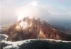
.jpg)
The island is largely unglaciated. It is approximately 3 nautical miles (5.6 kilometres) across with a peak elevation of 551 metres (1,808 feet) above sea level.[1][6]
Many of the island's headlands have been charted and named, generally in recognition of the island's odorous volcanic fumes.[7][8] Unless noted otherwise, the following names were applied by the United Kingdom Antarctic Place-Names Committee (UK-APC). Low-lying Reek Point is the island's northernmost point.[7] Pacific Point is a small rounded point on the island's northwest side. It was initially named Low Point by DI personnel, but was renamed for the Pacific in 1953 by UK-APC to avoid redundancy with other similarly named features.[2] Low-lying Acrid Point is found to the southwest.[9]
Stench Point is a conspicuous point forming the west extremity of the island. Originally named West Bluff in by DI personnel, it was renamed in 1971 by UK-APC to avoid duplication.[10] Noxious Bluff is a dark bluff 50 m (160 ft) high on the island's southwest coast.[11] Fume Point is a low-lying lava feature forming the island's southern point.[12] Pungent Point, a low, dark-colored lava cliff, forms the island's east point.[8]
Mount Asphyxia, a stratovolcano also known as Mount Curry,[6][13] dominates the western side of the island while the eastern half is a low-lying lava plain. It is an active volcano, with fresh lava reported in 1830 and numerous indications of activity since. Approximately 50% of the island is composed of tephra, a fragmental material produced by volcanic eruptions.[4]
See also
- List of Antarctic and sub-Antarctic islands
- List of volcanoes in South Sandwich Islands
Notes
- The spelling "Zavodovski" results from an earlier system of transliteration of the Russian name and has been retained because of long usage.[1]
References
- "Zavodovski Island". Geographic Names Information System. United States Geological Survey. Retrieved 2019-05-28.
- "Pacific Point". Geographic Names Information System. United States Geological Survey. Retrieved 2019-05-28.
- Planet Earth II: The natural world from a new angle, 2016-11-04, retrieved 2016-11-07
- "Satellite Spies Smoking, Hot Sandwich: Big Pic : Discovery News". Retrieved 2012-05-03.
- "Penguin colonies at risk from erupting volcano". phys.org. Retrieved 7 July 2016.
- "Zavodovski". Global Volcanism Program. Smithsonian Institution.
- "Reek Point". Geographic Names Information System. United States Geological Survey. Retrieved 2019-05-28.
- "Pungent Point". Geographic Names Information System. United States Geological Survey. Retrieved 2019-05-28.
- "Acrid Point". Geographic Names Information System. United States Geological Survey. Retrieved 2019-05-28.
- "Stench Point". Geographic Names Information System. United States Geological Survey. Retrieved 2019-05-28.
- "Noxious Bluff". Geographic Names Information System. United States Geological Survey. Retrieved 2019-05-28.
- "Fume Point". Geographic Names Information System. United States Geological Survey. Retrieved 2019-05-28.
- "Erupting Volcano May Have Destroyed Huge Penguin Colony". National Geographic News. 2016-07-06. Retrieved 2019-05-29.
Further reading
- LeMasurier, W. E.; Thomson, J. W., eds. (1990). Volcanoes of the Antarctic Plate and Southern Oceans. American Geophysical Union. pp. 512 pp. ISBN 0-87590-172-7.
- Zavodovski, South Sandwich Islands with images
Capital: King Edward Point | |||||||
| General | |||||||
| Settlements / Whaling stations | |||||||
| South Georgia islands | |||||||
| South Sandwich Islands |
| ||||||
| Landmarks |
| ||||||
![]()