Yuen Long District
Yuen Long District (Chinese: 元朗區; Cantonese Yale: Yùhn lóhng kēui, formerly romanised as Un Long) is one of the districts of Hong Kong. Located in the northwest of the New Territories, it had a population of 449,070 in 2001.
Yuen Long 元朗區 | |
|---|---|
| Yuen Long District | |
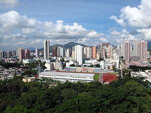 Day view of the Yuen Long District skyline | |
Official emblem | |
| |
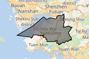
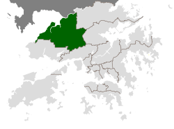 Location of Yuen Long District within Hong Kong | |
| Coordinates: 22°26′44″N 114°01′20″E | |
| Country | |
| Region | New Territories |
| Constituencies | 31 |
| Government | |
| • District Council Chairman | Mr WONG Wai-yin, Zachary |
| Area | |
| • Total | 138.43 km2 (53.45 sq mi) |
| Population (2011[1]) | |
| • Total | 578,529 |
| • Density | 4,200/km2 (11,000/sq mi) |
| Time zone | UTC+8 (Hong Kong Time) |
| Largest neighbourhood by population | Tin Shui Wai (286,232 – 2016 est)[2] |
| Website | Yuen Long District Council |
| Yuen Long District | |||||||||||||||
|---|---|---|---|---|---|---|---|---|---|---|---|---|---|---|---|
| Traditional Chinese | 元朗區 | ||||||||||||||
| Simplified Chinese | 元朗区 | ||||||||||||||
| Jyutping | Jyun4 long5 keoi1 | ||||||||||||||
| |||||||||||||||
Geography
Yuen Long District contains the largest alluvial plain in Hong Kong, the Yuen Long-Kam Tin plain. With an area of 144 km², the district covers many traditional villages including Ping Shan Heung, Ha Tsuen Heung, Kam Tin Heung, Pat Heung, San Tin Heung and Shap Pat Heung, as well as Yuen Long Town and Tin Shui Wai.
Two new towns have been developed within this district. Yuen Long New Town was developed from the traditional market town of Yuen Long Town from the late 1970s. Tin Shui Wai New Town has developed since the early 1990s, and is built on land reclaimed from former fish ponds once common in the district.
History
Since the Tang Dynasty, the Tang's clan has been living in Pat Heung. Like Tai Po, Yuen Long used to be a traditional market town.
Culture
Special festivals
The Tin Hau Festival (天后誕巡遊) is on the 23rd of the third month of the lunar calendar. It celebrates the birth of a local deity, Tin Hau. During the day, residents from various walled villages set off at Fung Cheung Road, go via Kau Yuk Road and the Yuen Long Stadium, and end at Tai Shu Ha Tin Hau Temple, which has a 300-year history.
Cuisine
- Poon choi (盤菜)
- Sweetheart cake (老婆餅)
Popular scenic spots
Hong Kong Wetland Park
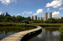
Hong Kong Wetland Park (香港濕地公園) is located at the northern part of Tin Shui Wai. It was intended to be an ecological mitigation area (EMA) for the wetlands lost due to Tin Shui Wai New Town development. In 1998, a project named as "International Wetland Park and Visitor Centre Feasibility Study" was initiated by the Agriculture, Fisheries and Conservation Department and the Hong Kong Tourism Board with a view to expanding the EMA to a wetland ecotourism attraction. After concluding that it was feasible to develop a wetland park at the EMA site without compromising its intended ecological mitigation functions and the development of the Wetland Park will also enhance the ecological function of the EMA to a world-class conservation, education and tourism facility, the concerned parties started the Wetland Park Project, which is regarded as one of the Millennium projects by the Administrations.
Kat Hing Wai
Kat Hing Wai (吉慶圍) in Kam Tin is one of the District's best-known walled villages. It is the ancestral home of the Tangs, one of the "Five Great Clans" in the territory. Built by the Tangs 500 years ago, it is a rectangular walled village with an area of 100 metres by 90 metres. As a family stronghold, Kat Hing Wai has served the Tangs well through centuries. In the Qing Dynasty, a five-metre high blue brick wall and four cannon towers were added to defend bandits.
Route: West Rail Line Kam Sheung Road Station or KMB routes 54, 64K and 77K
Nam Sang Wai
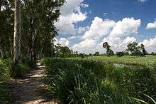
Nam Sang Wai (南生圍) covers a roughly triangular area. It is bordered by the Shan Pui River in the west, separating it from Yuen Long Industrial Estate, the Kam Tin River in the east and a branch of the Kam Tin River in the south. It is home to many birds, including seagulls, Northern Pintails (Anas acuta), Yellow-nib Ducks (Anas poecilorhyncha) and Black-faced Spoonbills (Platalea minor). Flora includes reeds and mangroves.
Mai Po Marshes
Mai Po Marshes (米埔) is located in the centre of the wetland and has achieved international significance as a stopping and feeding place for migratory birds along the East Asian-Australian Flyway. The birdwatching season runs from October to May and more than 300 types of birds have been recorded in the area, many of them are rarely seen anywhere outside the region.
Visitors may go to Mai Po by the following ways:
- From Central or Causeway Bay take route 968 to Yuen Long (West) Bus terminal, then change taxi.
- From Sheung Shui Station, take Bus 76K or red minibus 17 to Mai Po village, then walk to the Marsh (about 20 minutes).
On 30 Jan 2004, the Government suspended public visits to the Mai Po wetland reserve as a supposed measure to protect people from avian flu (H5N1).
Ping Shan Heritage Trail
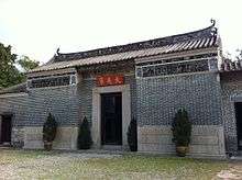
Ping Shan Heritage Trail (屏山文物徑), inaugurated on 12 December 1993, was designed to link several historic buildings and monuments owned by the Tang clan in Ping Shan (including Tsui Sing Lau Pagoda 聚星樓 and Tang Ancestral Hall 鄧氏宗祠) by a 1 km trail.
Route: LRT Ping Shan Stop, Hang Mei Tsuen Stop or West Rail Line Tin Shui Wai Station
Tai Fu Tai
Tai Fu Tai Mansion (大夫第) in San Tin was probably built in 1865 in the reign of the Qing Dynasty. It is a richly embellished residence situated on a spacious ground, with a large open space in the front and a garden at the back. The whole compound is surrounded by a green-brick wall. It is a fine example of traditional Chinese dwellings of the scholar-gentry class and is certainly one of the most elegant buildings throughout the territory.
Route: KMB Bus 76K to San Tin
Tai Lam Country Park
Tai Lam Country Park sits in the western New Territories with an area of 54 km². Tai Lam has a small area of porphyry in the northeast; for the remaining area, it is composed of highly erodible decomposed granite. In 1952, afforestation started as a measure to protect the water catchment area. In spite of the poor soil conditions and the setbacks of fire damage over the years, mature stands of Acacia confusa, Lophostemon confertus, Pinus massoniana, Pinus elliottii and Eucalyptus species now cover most of the area. In addition, the plantations also offer a good habitat for birds, pangolins, Chinese leopard cat, and barking deer. Nevertheless, Tai Lam is an excellent place for outdoor activities because of its remoteness.
Yuen Long Park
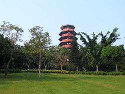
Yuen Long Park (元朗市鎮公園) is a park at Yuen Long Town with recreational facilities. There is a 7-storey pagoda enclosing an aviary, which has become a landmark of Yuen Long.
Route: LRT Shui Pin Wai Stop, LWB bus E34 or KMB Bus 68X, 268B, 268C, 268X, 269D, 276, 276P, B1,68E (get off the bus at Yuen Long Park.)
Leisure and cultural facilities
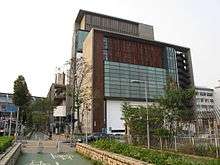
- Yuen Long Theatre was opened in May 2000. This modern performing arts venue has become a centre for the arts in the New Territories northwest. The Theatre is situated at Yuen Long Tai Yuk Road in the vicinity of Yuen Long Park, Yuen Long Stadium and the Public Swimming Pool. The bamboo courtyard is a focus within the foyer, which creates an ambiance of serenity and tranquility.
- Yuen Long Town Hall is located in Kau Yuk Road, near Yuen Long Police Station. It is to organise courses and leisure activities. There is also study room.
- Yuen Long Swimming Pool is situated at Tai Yuk Road. There are 5 Standard swimming pools for four seasons.
- Tin Shui Wai Swimming Pool and Tin Shui Wai Sports Centre are situated at 1 Tin Pak Road. There are 3 swimming pools for four seasons and a children swimming pool opened during summer.
- Yuen Long Public Library is on the first floor of Yuen Long Government Offices, 2 Kiu Lok Square, Yuen Long.
- Ping Shan Tin Shui Wai Public Library is at Ping Shan Tin Shui Wai Leisure and Cultural Building, 1 Tsui Sing Road, Tin Shui Wai.
- TSW Pegasus and Yuen Long District SA are both football teams based in Yuen Long Stadium.
Transport
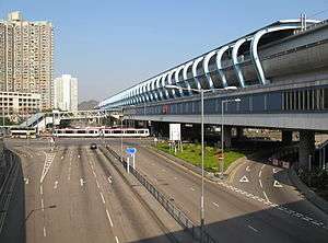
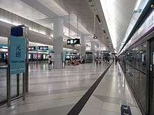
Located in the northwest of the New Territories, Yuen Long has a well-developed public transport network. It is easily accessible from different parts of Hong Kong by bus, mini-bus or railway.
- Bus services provided by Kowloon Motor Bus, Citybus and MTR
- West Rail Line and Light Rail services provided by MTR
- Public light buses
- Taxis, including the New Territories taxis (green taxis) and public taxis (public taxis).
The Hong Kong-Shenzhen Western Corridor bridge (深港西部通道) is the fourth cross-border route between Hong Kong and mainland China. It was completed and opened in 2007, and is 5.5 km long. It starts at Ngau Hom Shek (鰲磡石), located at the northwest of Yuen Long, and ends in Shekou, a harbour port located in Shenzhen.[3]
Statistical information
| Demographic characteristics | ||
|---|---|---|
| Population | 449,070 | |
| Proportion of population (%) | Aged under 15 | 20 |
| Aged 15–64 | 71 | |
| Aged 65 and over | 9 | |
| Median age | 33 | |
| Proportion of population aged 15 and over being never married (%) | Male | 32 |
| Female | 27 | |
| Education | ||
| School attendance rate of population aged 6–18 (%) | 92.9 | |
| Proportion of non-student population aged 20 and over having attained tertiary education (%) | 10.9 | |
| Labour force characteristics | ||
| Labour force | 219,444 | |
| Labour force participation rate (%) | Male | 74.0 |
| Female | 48.2 | |
| Both sexes | 60.9 | |
| Median monthly income from main employment of working population (HK$) | 10,588.7 | |
| Household characteristics | ||
| Number of domestic households | 137,211 | |
| Average domestic household size | 3.2 | |
| Median monthly domestic household income (HK$) | 16,763.5 | |
| Housing characteristics | ||
| Number of occupied quarters | 136,705 | |
| Average number of domestic households per unit of quarters | 1.01 | |
| Proportion of domestic households owning the quarters they occupy (%) | 48.15 | |
| Median monthly domestic household mortgage payment and loan repayment (HK$) | 7,693.83 | |
| Median mortgage payment and loan repayment to income ratio (%) | 24.63 | |
| Median monthly domestic household rent (HK$) | 2,513.04 | |
| Median rent to income ratio (%) | 16.36 | |
See also
- List of buildings, sites and areas in Hong Kong
- Yuen Long Tin Shui Wai Democratic Alliance
- Yuen Long Town
Footnotes
- "2011 Population Census: Summary Results" (in English and Chinese). Census and Statistics Department, Hong Kong Government. 2011. Retrieved 11 June 2012.
- District Profiles, Hong Kong Government, 8 December 2017, retrieved 15 April 2020
- Route: Number 10
External links
- Yuen Long District Council
- List and map of electoral constituencies (large PDF file)
- Yuen Long New Town
- Tin Shui Wai New Town
- Yuen Long Theatre
- Yuen Long Town Hall
- Yuen Long New Town
- Hong Kong government pamphlet about the development of the new town
- Hong Kong Tourism Board
- WWF Hong Kong
- Hong Kong Wetland Park
- Yuen Long Special
- The incredible journey of Yuen Long
Places adjacent to Yuen Long District | |
|---|---|