West Burton, North Yorkshire
West Burton is a village in Bishopdale, a side valley of Wensleydale, in the Yorkshire Dales, North Yorkshire, England. It lies 6.2 miles (10 km) south west of Leyburn and 22.3 miles (35.9 km) west of the County Town of Northallerton. It is the largest settlement in the civil parish of Burton-cum-Walden.
| West Burton | |
|---|---|
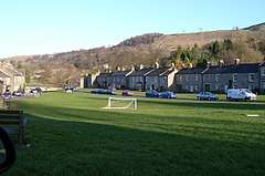 West Burton village green | |
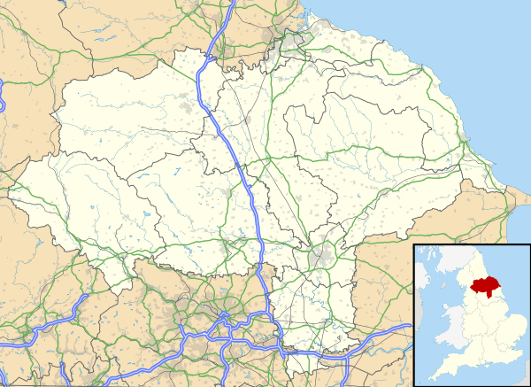 West Burton Location within North Yorkshire | |
| Population | 303 |
| OS grid reference | SE018870 |
| Civil parish | |
| District | |
| Shire county | |
| Region | |
| Country | England |
| Sovereign state | United Kingdom |
| Post town | LEYBURN |
| Postcode district | DL8 4 |
| Police | North Yorkshire |
| Fire | North Yorkshire |
| Ambulance | Yorkshire |
| UK Parliament | |
History
There is some evidence of an Iron Age settlement on top of nearby Burton Moor that has been designated a Scheduled Ancient Monument. It consists of about eighteen hut circles and defined fields.[1]
The village is mentioned in the Domesday Book as just Burton. The topynomy of the village is derived from the Old English burh-tūn meaning a fortified farm.[2][3] Until the 17th century the village was known as Burton in Bishopdale.[4] "West" distinguishes the village from the village of Constable Burton, 9 miles (14 km) to the east, also known simply as Burton in the early Middle Ages.
At the time of the Norman invasion the village was part of the manor belonging to Thorkil, but afterwards the manor was granted to Geoffrey of Swaffham by Count Alan of Brittany, who had been awarded the lands by the Crown.[5] West Burton (or Burton in Bishopdale or Burton-cum-Walden) was a manor or township of the ancient parish of Aysgarth, and was always coupled with Walden.[4] The manor befell the same fate as other lands belonging to Geoffrey in that they eventually passed to Richard Duke of Gloucester in 1480. Thereafter the descent of the manor followed that of Castle Bolton into the 19th century.[4][6]

The village used to be an important market town and the octagonal market cross and stocks are still seen today on the village green.[6]
Burton-cum-Walden became a separate civil parish in 1866.[7]
Governance
The village is in the Richmond UK Parliament constituency. It is also in the Penhill ward of Richmondshire District Council and the Upper Dales electoral division of North Yorkshire County Council.[8] Burton-cum-Walden Parish Council has five Councillors and a parish clerk.[9]
Geography

West Burton lies within the Yorkshire Dales National Park[10] on the B6160 road to Addingham. Two other roads leave the village, both dead ends, but one leads to the two hamlets of Walden and Walden Head. The villages of Aysgarth, Newbiggin and Thoralby are all about a mile from the village. West Burton lies near the mouth of Bishopdale and at the mouth of Waldendale, the valley through which Walden Beck runs. Walden Beck runs north past the eastern edge of the village to join Bishopdale Beck on its way to the River Ure.[8]
Cauldron Force or Falls, (also called West Burton Falls), is a small waterfall in the village. It is only a short walk from the centre of the green.[11]
Demography
Population figures are for the whole parish of Burton-cum-Walden.
| Population[12][13][14] | ||||||||||
| Year | 1881 | 1891 | 1901 | 1911 | 1921 | 1931 | 1951 | 1961 | 2001 | 2011 |
|---|---|---|---|---|---|---|---|---|---|---|
| Total | 444 | 425 | 367 | 314 | 385 | 367 | 294 | 266 | 311 | 303 |
2001 census
The 2001 UK census showed that the population was split 48.5% male to 51.5% female. The religious constituency was made of 72.3% Christian and the rest stating no religion or not stating at all. The ethnic make-up was 98.7% White British and 1.3% White other. There were 178 dwellings.[13]
2011 census
The 2011 UK census showed that the population was split 48.8% male to 51.2% female. The religious constituency was made of 66.7% Christian, 0.3% Jewish, 0.3% Buddhist, 1.6% Hindu and the rest stating no religion or not stating at all. The ethnic make-up was 94.4% White British, 1.3% Mixed Ethnic, 2.3% Asian British and 2.0% each White Other. There were 192 dwellings.[14]
Community and culture
Education in the village is provided at West Burton Primary school.[15] The school was built in 1873.[6] Pupils receive secondary education at The Wensleydale School & Sixth Form in Leyburn.[16] There are a number of local businesses including a butchers shop, a small pottery, general store and a public house.[17]
Notable people
In their retirement, musical theatre actress Pat Kirkwood and her husband Peter Knight, the former president of Bradford & Bingley, lived in the village for ten years.[18]
Religion

The Wesleyan and Independent Methodists both built chapels in the village in 1813 and 1851 respectively. The Wesleyan Methodist chapel was rebuilt in 1898.[6][4][19]
References
- Historic England. "Settlement on Burton Moor (1004064)". National Heritage List for England. Retrieved 24 May 2017.
- Watts (2011). Cambridge Dictionary of English Place-names. Cambridge University Press. pp. 104–5. ISBN 978-0521168557.
- Mills, A.D. (1998). Dictionary of English Place-Names. Oxford Paperbacks. pp. 88–9. ISBN 978-0192800749.
- Page, William, ed. (1914). "Parishes: Aysgarth". Victoria County History. A History of the County of York North Riding: Volume 1. Institute of Historical Research. Retrieved 22 March 2013.
- West Burton in the Domesday Book. Retrieved 2 April 2013.
- Bulmer's Topography, History and Directory (Private and Commercial) of North Yorkshire 1890. S&N Publishing. 1890. p. 342. ISBN 1-86150-299-0.
- Vision of Britain website
- Ordnance Survey Open Viewer
- "Parish Council". West Burton and Walden. Retrieved 2 April 2013.
- http://www.walkingwiththetaxidriver.co.uk/the-walks/yorkshire-dales/west-burton-to-aysgarth-falls-and-cauldron-falls-round/
- https://www.google.com/maps/place/Cauldron+Falls/@54.2762318,-1.9747828,17z/data=!3m1!4b1!4m5!3m4!1s0x487c11a4b58ca76f:0x6fe9d56106799890!8m2!3d54.2762318!4d-1.9725941
- "Population at Cenuses". Vision of Britain. 2009. Retrieved 22 March 2013.
- "2001 UK Census". Office for National Statistics. 2002. Retrieved 25 March 2013.
- "2011 UK Census". Office for National Statistics. 2013. Retrieved 25 March 2013.
- "Primary School Info". Retrieved 26 March 2013.
- "Secondary School Admissions – Northallerton Area". North Yorkshire County Council. 2013. Archived from the original on 4 October 2012. Retrieved 26 March 2013.
- "Amenities". Retrieved 2 April 2013.
- "Bared on stage: What Prince Philip wrote to star Pat Kirkwood". Yorkshire Post. 3 October 2012.
- "Methodist Church". The Methodist Church. Retrieved 2 April 2013.
External links
| Wikimedia Commons has media related to West Burton, North Yorkshire. |