Virgil, Illinois
Virgil is a village in Virgil Township, Kane County, Illinois, United States. It was incorporated on November 6, 1990.[6] The population was 329 at the 2010 census,[7] up from 266 in 2000.
Virgil, Illinois | |
|---|---|
Village | |
| Motto(s): "Rooted in the Past with Pride & Tradition"[1] | |
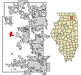 Location of Virgil in Kane County, Illinois | |
.svg.png) Location of Illinois in the United States | |
| Coordinates: 41°57′24″N 88°31′43″W | |
| Country | United States |
| State | Illinois |
| County | Kane |
| Township | Virgil |
| Settled | 1836 |
| Incorporated | 1990 |
| Government | |
| • Type | Mayor–council |
| • Village President | Jamie LeBlanc |
| Area | |
| • Total | 2.11 sq mi (5.45 km2) |
| • Land | 2.11 sq mi (5.45 km2) |
| • Water | 0.00 sq mi (0.00 km2) |
| Elevation | 866 ft (264 m) |
| Population (2010) | |
| • Total | 329 |
| • Estimate (2019)[3] | 327 |
| • Density | 155.27/sq mi (59.95/km2) |
| Time zone | UTC-6 (CST) |
| • Summer (DST) | UTC-5 (CDT) |
| ZIP Code(s) | 60151, 60182 |
| Area code(s) | 630/331 |
| FIPS code | 17-78175 |
| Wikimedia Commons | Virgil, Illinois |
| Website | villageofvirgil |
| [4][5] | |
History
.jpg)
Virgil was the site of the 2010 Illinois earthquake's epicenter in the early morning hours of February 10.[8][9]
Geography
Virgil is located in western Kane County at 41°57′24″N 88°31′43″W (41.9566341, -88.5286920).[4] Illinois Route 64 passes through the village center, leading east 12 miles (19 km) to St. Charles and west 8 miles (13 km) to Sycamore.
According to the 2010 census, Virgil has a total area of 2.11 square miles (5.46 km2), all land.[10]
Demographics
| Historical population | |||
|---|---|---|---|
| Census | Pop. | %± | |
| 2000 | 266 | — | |
| 2010 | 329 | 23.7% | |
| Est. 2019 | 327 | [3] | −0.6% |
| U.S. Decennial Census[11] | |||
As of the census[5] of 2000, there were 266 people, 86 households, and 73 families residing in the village. The population density was 141.3 inhabitants per square mile (54.6/km2). There were 89 housing units at an average density of 47.3 per square mile (18.3/km2). The racial makeup of the village was 97.37% White, 1.13% African American, 0.38% Asian, 0.38% from other races, and 0.75% from two or more races. Hispanic or Latino of any race were 1.88% of the population.
There were 86 households, out of which 50.0% had children under the age of 18 living with them, 69.8% were married couples living together, 11.6% had a female householder with no husband present, and 14.0% were non-families. 12.8% of all households were made up of individuals and 3.5% had someone living alone who was 65 years of age or older. The average household size was 3.09 and the average family size was 3.38.
In the village, the population was spread out with 35.3% under the age of 18, 4.9% from 18 to 24, 33.5% from 25 to 44, 22.6% from 45 to 64, and 3.8% who were 65 years of age or older. The median age was 33 years. For every 100 females, there were 98.5 males. For every 100 females age 18 and over, there were 93.3 males.
The median income for a household in the village was $78,252, and the median income for a family was $80,687. Males had a median income of $45,000 versus $30,417 for females. The per capita income for the village was $26,881. None of the families and 0.4% of the population were living below the poverty line.
See also
- List of towns and villages in Illinois
References
- "Welcome to Virgil, Illinois". Village of Virgil. Retrieved February 14, 2019.
- "2019 U.S. Gazetteer Files". United States Census Bureau. Retrieved July 14, 2020.
- "Population and Housing Unit Estimates". United States Census Bureau. May 24, 2020. Retrieved May 27, 2020.
- U.S. Geological Survey Geographic Names Information System: Village of Virgil
- "Virgil village, Illinois - Fact Sheet". American FactFinder. U.S. Census Bureau. 2000. Archived from the original on 15 February 2020. Retrieved 16 February 2010.
- Official website
- "Geographic Identifiers: 2010 Demographic Profile Data (G001): Virgil village, Illinois". American Factfinder. U.S. Census Bureau. Retrieved February 14, 2019.
- "Small earthquake wakes up northern Ill., no damage". WGEM-TV. 10 February 2010. Retrieved 16 February 2010.
- Greene, Richard Allen (10 February 2010). "Earthquake rattles northern Illinois". CNN. Retrieved 16 February 2010.
- "G001 - Geographic Identifiers - 2010 Census Summary File 1". United States Census Bureau. Archived from the original on 2020-02-13. Retrieved 2015-12-25.
- "Census of Population and Housing". Census.gov. Retrieved June 4, 2015.
External links
Municipalities and communities of Kane County, Illinois, United States | ||
|---|---|---|
| Cities | Map of Illinois highlighting Kane County | |
| Villages | ||
| Townships | ||
| CDP | ||
| Other unincorporated communities | ||
| Footnotes | ‡This populated place also has portions in an adjacent county or counties | |