Vintar
Vintar, officially the Municipality of Vintar (Ilocano: Ili ti Vintar; Tagalog: Bayan ng Vintar), is a 1st class municipality in the province of Ilocos Norte, Philippines. According to the 2015 census, it has a population of 32,220 people.[3]
Vintar | |
|---|---|
| Municipality of Vintar | |
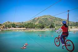 Vintar Bikeline 2020 | |
Seal | |
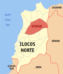 Map of Ilocos Norte with Vintar highlighted | |
| |
.svg.png) Vintar Location within the Philippines | |
| Coordinates: 18°13′30″N 120°39′00″E | |
| Country | |
| Region | Ilocos Region (Region I) |
| Province | Ilocos Norte |
| District | 1st District |
| Founded | 1909 |
| Barangays | 34 (see Barangays) |
| Government | |
| • Type | Sangguniang Bayan |
| • Mayor | Larisa C. Foronda |
| • Vice Mayor | Amado Victor R. Racimo Jr. |
| • Congressman | Ria Christina G. Fariñas |
| • Electorate | 22,187 voters (2019) |
| Area | |
| • Total | 614.35 km2 (237.20 sq mi) |
| Population (2015 census)[3] | |
| • Total | 32,220 |
| • Density | 52/km2 (140/sq mi) |
| • Households | 7,686 |
| Economy | |
| • Income class | 1st municipal income class |
| • Poverty incidence | 8.5% (2015)[4] |
| • Revenue (₱) | 203,671,145.69 (2016) |
| Time zone | UTC+8 (PST) |
| ZIP code | 2915 |
| PSGC | |
| IDD : area code | +63 (0)77 |
| Climate type | tropical monsoon climate |
| Native languages | Ilocano Tagalog |
| Website | www |
Vintar is the largest municipality in Ilocos Norte. Its patron saint is Saint Nicholas de Tolentino. It is home to one of the biggest convents in the province where it houses the Saint Nicholas Academy. It is also where Vintar Dam is located, first dam funded by the World Bank in Southeast Asia- an important cultural property listed by the National Commission for Culture and the Arts (NCCA) and is also the site of the Umok ni Siwawer Eco-Tourism Nature Park, the town's popular picnic resort.
History
Vintar derived its name from the Ilocano word, "intar", which used to describe the formation or order taken by the subject from their ruler whenever the chief called them to attention. It is said that a visiting Spanish missionary heard the word and added the letter V, referring to the “V” formation that the missionary saw.
The town's earliest settlers are believed to be of Malay in origin. They first settled on a hill overlooking the Bislak. The town was founded by the Spanish missionaries who got lost in the woods while hunting between Sarrat and Piddig. Vintar became a visita of Bacarra but it was later established as a Parish of San Nicolas de Tolentino. Earlier in 1763, Vintar was reverted to a visita until it became independent in 1774.
In 1903, Vintar was annexed as a barrio of Bacarra. It gained its separation and independence in 1909. The town is also home to one of the biggest convents in the Province of Ilocos Norte. In 1931, an earthquake partially destroyed its church and convent. Five years later, it was restored. The convent which houses the Saint Nicolas Academy was restored in 1982. Vintar celebrates the feast of St. Nicholas every 10 September- a religious tradition inherited from the Augustinians lives that still practice the distribution of “tinapay ni San Nicolas” (unleavened bread). But the Siwawer Festival, the annual town fiesta of Vintar is held from December 26–30 of every year.
The people of Vintar engage in farming, fishing and herding. The town is generally rural but famous all over the province for its beautiful women with strongly Spanish features. Hence the town has its monicker, “The Home of Beautiful People”. Vintar is also the site of four (4) important cultural properties listed by the National Commission for Culture and the Arts. These are Vintar Dam, the Old Municipal Building, San Nicolas de Tolentino Parish Church and the Gabaldon Building.
The Municipality of Vintar is headed by the Local Chief Executive, Mayor Larisa Cadavona Foronda from 2016 up to present.
Geography

Vintar is located on a plain land surrounded by mountains. Vintar is surrounded and bordered by:
- Bangui, Adams, Dumalneg, Burgos and Pagudpud in the north;
- Laoag, Sarrat, Piddig, and Carasi in the south;
- Pasuquin and Bacarra in the west;
- Calanasan, Apayao in the east.
The town is considered as the sixth major river system in the region. Its head waters are on the western Cordillera slopes at the Kalinga and Apayao borders. It flows eastward and irrigates most of the flat lands of Ilocos Norte before making its exit into the China Sea. Vintar has the largest land area in Ilocos Norte.
Climate
Vintar is divided into two types of climate:
- 90% or the Western Part: Two pronounced seasons, dry from December to May and wet from June to November. Maximum rain period is from June to September.
- 10% or the Eastern Part: No very pronounced maximum rain period, with a short dry season lasting only from one to three months.
| Climate data for Vintar, Ilocos Norte | |||||||||||||
|---|---|---|---|---|---|---|---|---|---|---|---|---|---|
| Month | Jan | Feb | Mar | Apr | May | Jun | Jul | Aug | Sep | Oct | Nov | Dec | Year |
| Average high °C (°F) | 26 (79) |
28 (82) |
30 (86) |
32 (90) |
31 (88) |
31 (88) |
30 (86) |
30 (86) |
30 (86) |
29 (84) |
28 (82) |
26 (79) |
29 (85) |
| Average low °C (°F) | 20 (68) |
20 (68) |
21 (70) |
23 (73) |
25 (77) |
25 (77) |
25 (77) |
25 (77) |
24 (75) |
23 (73) |
22 (72) |
21 (70) |
23 (73) |
| Average precipitation mm (inches) | 55 (2.2) |
41 (1.6) |
37 (1.5) |
41 (1.6) |
184 (7.2) |
215 (8.5) |
261 (10.3) |
256 (10.1) |
245 (9.6) |
216 (8.5) |
142 (5.6) |
129 (5.1) |
1,822 (71.8) |
| Average rainy days | 14.1 | 11.1 | 11.8 | 12.5 | 21.8 | 25.2 | 25.5 | 24.9 | 23.8 | 18.2 | 16.4 | 17.0 | 222.3 |
| Source: Meteoblue [5] | |||||||||||||
Barangays
Vintar is politically subdivided into 33 barangays. [2]
- 1- San Roque (Poblacion)
- 2- San Nicolas (Poblacion)
- 3- San Pedro (Poblacion)
- 4- Santa Maria (Poblacion)
- 5- San Ramon (Poblacion)
- 6- Parut
- 7- Alejo Malasig/Pait
- 8- Margaay
- 9- Lubnac
- 10- Parparoroc
- 11- Bulbulala (Pallas)
- 12- Namoroc (Pallas)
- 13- Mabanbanag (Pallas)
- 14- Ester (Pallas)
- 15- Visaya
- 16- Salsalamagui
- 17- P.F. Alviar (Amian)
- 18- Abkir (Amian)
- 19- Columbia (Amian)
- 20- Cabisuculan (Amian)
- 21- Malampa (Amian)
- 22- Manarang (Amian)
- 23- Dipilat
- 24- Alsem
- 25- Tamdagan
- 26- Canaam
- 27- Esperanza
- 28- Bago
- 29/30- San Jose/ Sto. Tomas
- 31- Dagupan
- 32- Cabangaran
- 33- Cabayo
- 34- Isic Isic
Sub-divisions
Poblacion
Poblacion is the center-most subdivision of Vintar. Poblacion is composed of 5 barangays namely:
- 1- San Roque
- 2- San Nicolas
- 3- San Pedro
- 4- Santa Maria
- 5- San Ramon
Metro Poblacion
Metro Poblacion is composed of 5 barangays namely:
- 6- Parut
- 7- Alejo Malasig
- 8- Margaay
- 9- Lubnac
- 10- Parparoroc
Pallas Valley
It is located at the north-east of Vintar. Pallas Valley is composed of 4 barangays namely:
- 11- Bulbulala
- 12- Namoroc
- 13- Mabanbanag
- 14- Ester
North of the River (Amian ti Karayan)
North of the River or "Amian ti Karayan" is located north of the Bislak River from Poblacion. It is called so after the Ilocano word "Amian" which means north. Amian ti Karayan is composed of 8 barangays namely:
- 16- Salsalamagui
- 17- P.F. Alviar
- 18- Abkir
- 19- Columbia
- 20- Cabisuculan
- 21- Malampa
- 22- Manarang
- 24- Alsem
Lower Surong Valley
- 15- Visaya
- 23- Dipilat
- 25- Tamdagan
- 26- Canaam
- 27- Esperanza
- 28- Bago
- 29/30- San Jose/Sto.Tomas
Upper Surong Valley
Upper Surong Valley is composed of 4 barangays namely:
- 31- Dagupan
- 32- Cabangaran
- 33- Cabayo
- 34- Isic Isic
Mount Baguinsuso
Mount Baguinsuso, also known as Mount Masadsada (Ilocano which means "passable valley"), is among the most recognized landmarks located in Barangay 14- Ester.
Demographics
|
| |||||||||||||||||||||||||||||||||||||||||||||
| Source: Philippine Statistics Authority[3][6][7][8] | ||||||||||||||||||||||||||||||||||||||||||||||
In the 2015 census, the population of Vintar was 32,220 people,[3] with a density of 52 inhabitants per square kilometre or 130 inhabitants per square mile.
Festival
Siwawer Festival is the annual festival of Vintar. This festival of the town is being celebrated in honor of the siwawer the local name of the brahminy kite species of eagle that soars the skies of Vintar. The Festival starts on December 4 which is also the Vintar Day, the foundation of the municipality when it was separated from the town of Bacarra in 1909.
Transportation
Vintar can be reached through air via Laoag International Airport at Laoag City, then hiring a tricycle or any other public transportation. From Manila by bus, it will take about 10 to 12 hours in reaching the center of Vintar. Farinas and Maria De Leon are the major companies that have a daily trip to Vintar.
Government seal
The shield is derived from the provincial seal of Ilocos Norte.
The letter V stands for the word Vintar, the name of the municipality.
The eagle represents the native hawk, commonly called Siwawer by the old folks and after which the people of Vintar are referred to.
Landscape, plow, rice stalk, onion, garlic, mango, eggplant and tobacco leaf, at the left side of the shield representing the municipality's principal farming industries.
Dam, gate valve, water and fish at the right side of the shield represent Vintar-Laoag-Bacarra irrigation system. The dam also stands for the Siwawers, a resort the town is famous for; the fish symbolizes one of the main income-generating products of the locality.
References
- "Municipality". Quezon City, Philippines: Department of the Interior and Local Government. Retrieved 31 May 2013.
- "Province: Ilocos Norte". PSGC Interactive. Quezon City, Philippines: Philippine Statistics Authority. Retrieved 12 November 2016.
- Census of Population (2015). "Region I (Ilocos Region)". Total Population by Province, City, Municipality and Barangay. PSA. Retrieved 20 June 2016.
- "PSA releases the 2015 Municipal and City Level Poverty Estimates". Quezon City, Philippines. Retrieved 1 January 2020.
- "Vintar: Average Temperatures and Rainfall". Meteoblue. Retrieved 4 March 2020.
- Census of Population and Housing (2010). "Region I (Ilocos Region)". Total Population by Province, City, Municipality and Barangay. NSO. Retrieved 29 June 2016.
- Censuses of Population (1903–2007). "Region I (Ilocos Region)". Table 1. Population Enumerated in Various Censuses by Province/Highly Urbanized City: 1903 to 2007. NSO.
- "Province of Ilocos Norte". Municipality Population Data. Local Water Utilities Administration Research Division. Retrieved 17 December 2016.
External links
| Wikimedia Commons has media related to Vintar, Ilocos Norte. |
- Vintar Profile at PhilAtlas.com
- Philippine Standard Geographic Code
- Philippine Census Information
- Local Governance Performance Management System
Places adjacent to Vintar | |
|---|---|
Laoag (capital) | |
| Municipalities | |
| Component cities | |
| Barangays | |