Village St. George, Louisiana
Village St. George is a census-designated place (CDP) in East Baton Rouge Parish, Louisiana, United States. The population was 7,104 at the 2010 census.[1] It is part of the Baton Rouge Metropolitan Statistical Area.
Village St. George, Louisiana | |
|---|---|
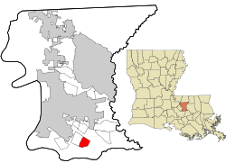 Location in East Baton Rouge Parish and the state of Louisiana. | |
| Coordinates: 30°21′46″N 91°04′05″W | |
| Country | United States |
| State | Louisiana |
| Parish | East Baton Rouge |
| Area | |
| • Total | 2.2 sq mi (6 km2) |
| • Land | 2.2 sq mi (6 km2) |
| • Water | 0.0 sq mi (0 km2) |
| Elevation | 36 ft (11 m) |
| Population (2010) | |
| • Total | 7,104 |
| • Density | 3,200/sq mi (1,200/km2) |
| Time zone | UTC-6 (CST) |
| • Summer (DST) | UTC-5 (CDT) |
| Area code(s) | 225 |
It is in the proposed City of St. George.[2]
Geography
Village St. George is located in southern East Baton Rouge Parish at 30°21′46″N 91°4′5″W (30.362642, -91.068049).[3] It is bordered to the west, across Siegen Lane, by Oak Hills Place. Downtown Baton Rouge is 10 miles (16 km) to the northwest.
According to the United States Census Bureau, the CDP has a total area of 2.2 square miles (5.8 km2), all land.[1]
Demographics
As of the census[4] of 2000, there were 6,993 people, 2,570 households, and 1,888 families residing in the CDP. The population density was 3,150.3 people per square mile (1,216.2/km2). There were 2,646 housing units at an average density of 1,192.0 per square mile (460.2/km2). The racial makeup of the CDP was 71.37% White, 23.68% African American, 0.19% Native American, 2.62% Asian, 0.01% Pacific Islander, 0.53% from other races, and 1.60% from two or more races. Hispanic or Latino of any race were 3.32% of the population.
There were 2,570 households out of which 42.1% had children under the age of 18 living with them, 56.1% were married couples living together, 13.9% had a female householder with no husband present, and 26.5% were non-families. 20.9% of all households were made up of individuals and 3.6% had someone living alone who was 65 years of age or older. The average household size was 2.72 and the average family size was 3.20.
In the CDP, the population was spread out with 29.8% under the age of 18, 9.4% from 18 to 24, 34.0% from 25 to 44, 22.2% from 45 to 64, and 4.6% who were 65 years of age or older. The median age was 32 years. For every 100 females, there were 91.5 males. For every 100 females age 18 and over, there were 86.3 males.
The median income for a household in the CDP was $55,646, and the median income for a family was $64,255. Males had a median income of $48,333 versus $30,189 for females. The per capita income for the CDP was $25,742. About 5.3% of families and 6.7% of the population were below the poverty line, including 8.7% of those under age 18 and 14.8% of those age 65 or over.
Education
East Baton Rouge Parish Public Schools serves Village St. George.[5]
Most of the community is served by Wildwood Elementary School. Some parts of northern Village St. George are zoned to Jefferson Terrace Elementary in Inniswold, and a small portion to the northwest is zoned to Westminster Elementary School in Westminster.[6] Most of the area is served by Kenilworth Middle School, while Woodlawn Middle School serves a section in the north. As of 2016 Kenilworth is under the administration of the Recovery School District of Louisiana, and the portion of the Kenilworth zone which houses most of the CDP has Woodlawn Middle School, directly controlled by EBR Schools, as an option.[7] Residents are served by Woodlawn High School in Old Jefferson.[8]
References
- "Geographic Identifiers: 2010 Demographic Profile Data (G001): Village St. George CDP, Louisiana". American Factfinder. U.S. Census Bureau. Archived from the original on February 13, 2020. Retrieved February 9, 2016.
- "Map". City of St. George. Retrieved 2019-11-17.
- "US Gazetteer files: 2010, 2000, and 1990". United States Census Bureau. 2011-02-12. Retrieved 2011-04-23.
- "U.S. Census website". United States Census Bureau. Retrieved 2008-01-31.
- "2010 CENSUS - CENSUS BLOCK MAP: Village St. George CDP, LA." U.S. Census Bureau. Retrieved on January 6, 2017.
- "Elemementary-School-Boundary-Descriptions-15-16.pdf Archived 2017-01-06 at the Wayback Machine." East Baton Rouge Parish Public Schools. Retrieved on January 7, 2017. Wildwood is on p. 39/41. Jefferson Terrace is on p. 17/41. Westminster is on page 37/41.
- "Middle-School-Boundary-Descriptions-15-16.pdf Archived 2017-01-06 at the Wayback Machine." East Baton Rouge Parish Public Schools. Retrieved on January 6, 2017. Kenilworth's zone is on p. 7/14 while Woodlawn Middle's map is on p. 14/14.
- "High-School-Boundary-Descriptions-15-16.pdf Archived 2016-04-18 at the Wayback Machine." East Baton Rouge Parish Public Schools. Retrieved on January 6, 2017. Woodlawn is on p. 10/10.
Municipalities and communities of East Baton Rouge Parish, Louisiana, United States | ||
|---|---|---|
Parish seat: Baton Rouge | ||
| Cities | 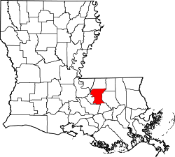 | |
| CDPs | ||
| Unincorporated communities |
| |