Vahdat District
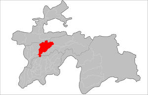
Vahdat District (also spelled Vakhdat,[lower-alpha 1] Tajik: Ноҳияи Ваҳдат, romanized: Nohiyayi Vahdat) is one of the larger districts of the Districts of Republican Subordination in Tajikistan, called Kofarnihon District until the introduction of a new administrative division in the end of 2003. During the Soviet period it was named Ordzhonikidzeabad district in honor of Georgian communist Grigoriy Ordzhonikidze. It extends east of Dushanbe along the southern slopes of the Gissar Range, bordering on Varzob District from the west and Rasht District from the east. Its long southern border runs (from west to east) along Khatlon Province and then Faizobod, Roghun, and Nurobod districts. The district capital Vahdat (formerly Ordzhonikidzeabad) is placed off-center at the extreme southwest of the district, just 10 km east of Dushanbe.[1]
Administrative divisions
The district is divided administratively into jamoats. They are as follows (and population).[2]
| Jamoats of Vahdat District | |
| Jamoat | Population |
|---|---|
| Bahor | 22258 |
| Chorsu | 2871 |
| Chuyangaron | 13070 |
| Eksiguzar | 23131 |
| Karasu | 25513 |
| Khojabaykul | 14263 |
| Kofarnihon | 29682 |
| Romit | 10338 |
| Simiganj | 24249 |
| Yangibozor | 17178 |
Notes
- from the Russian romanization of Вахдат.
References
- Republic of Tajikistan, map showing administrative division as of January 1, 2004, "Tojikkoinot" Cartographic Press, Dushanbe
- "List of Jamoats". UN Coordination, Tajikistan. Archived from the original on July 16, 2011. Retrieved April 4, 2009.
Capital: Dushanbe | ||
| Districts |  | |
| Main cities and towns | ||
| Geography | ||