Uturoa
Uturoa is a commune located in Raiatea, the largest island of the Îles Sous le Vent (Leeward Islands) in French Polynesia.[1] It is situated in between the administrative subdivision of Leeward Islands[2] and the main port of the island of Raiatea.[3] According to the 2017 census, Uturoa has a population of 3,778 individuals.[4] The commune spans approximately 120 miles (193.121 km) northwest of Papeete, the capital of French Polynesia.
'Uturoa | |
|---|---|
 Location of the commune (in red) within the Leeward Islands | |
Location of 'Uturoa 
| |
| Coordinates: 16°43′52″S 151°26′35″W | |
| Country | France |
| Overseas collectivity | French Polynesia |
| Subdivision | Leeward Islands |
| Government | |
| • Mayor (2014-2020) | Sylviane Terooatea |
| Area 1 | 15 km2 (6 sq mi) |
| Population (2017) | 3,736 |
| • Density | 250/km2 (650/sq mi) |
| Time zone | UTC−10:00 |
| INSEE/Postal code | 98758 /98735 |
| Elevation | 0–479 m (0–1,572 ft) |
| 1 French Land Register data, which excludes lakes, ponds, glaciers > 1 km2 (0.386 sq mi or 247 acres) and river estuaries. | |
History
The first settlers of Uturoa were early Polynesians that came from Southeast Asia. They built simple shelters using grass and tree branches. Their diet consisted mostly of fish, wild animals, wild tubers, honey, and wild fruits. The first European to visit Uturoa was the Portuguese navigator Pedro Fernandez de Quirós in 1606. Quirós referred to the island as The Fugitive in his maps.[5]
In the 18th century, the famed British explorer Captain James Cook visited Uturoa during his attempt to map the Pacific Ocean. Later on, Charles Darwin visited Uturoa, while also exploring the Society Islands. The forces of Queen Mamea raided Uturoa in 1896, in retaliation for the French annexation of her kingdom, and killed several traders.[6] Don the Beachcomber also lived in Uturoa for many years before it was raided.
Government
The current mayor of Uturoa is Sylviane Terooatea was re-elected for a second term in 2014 with a mandate until 2020.[7] Preceding the current mayor was Fillippe Brotherson, who served for 39 years.[8]
Geography
Uturoa is located approximately 209 miles (336 km) from Teahupo'o, a district in Tahiti, and is located close to a reef break. It is the northernmost point on the island of Raiatea and features the views of Bora Bora, Taha'a, and Huahine. The commune is approximately 5 ft (1.5 m) above sea level. The mountains of Uturoa from coastal ranges, as they are not located very far inland. Uturoa is situated between the small pass of Taha'a and the forest-covered mountains of Raiatea. Mount Tapioi, 294 meters high, is one of the best vantage points to observe the lagoon and the neighbouring islands.[9] Certain beaches of Uturoa contain black sand, partially due to past volcanic eruptions.
Uturoa shares the island of Raiatea with the communes Taputapuatea to the southeast and Tumaraa to the south. The nearest other islands are Huahine, located about 31 miles (50 km) east from Raiatea, and are home to the large community of Fare and Tahaa, which sits just across the strait to the north. The main island of Bora Bora (Anau) can be seen from Uturoa.
Weather
The climate of Uturoa is mild and rainy, with temperatures usually ranging between 20–30 degrees Celsius (68–86 °F) throughout the year. During the rainy season (November–May), it rains an average of 17 days per month. Humidity levels hover around 80% and remain consistent throughout the year, with the sun shining an average of 200 hours a month. August is typically the driest month and December–January is the wettest months.[10]
Transportation Facilities
Airport
Raiatea Airport (IATA code RFP, ICAO code NTTR) is a single-runway airport located in the east of Uturoa serviced by Air Tahiti. There are 157 flights on 5 different routes, connecting Raiatea Airport to the nearby islands of Papeete, Huahine, Bora Bora, Maupiti, and Moorea. The airport's runway was constructed from concrete, and it ends at Uturoa's eastern edge.[11]
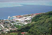
Harbor
Ferries from Raiatea sail to Tahaa in the north, Vaitape/Bora Bora in the northwest, and Tahiti in the southeast. The harbour's size is limited by a short coastline. Matira Beach, Bora Bora is a popular tourist destination in Uturoa. It is one of the few limited public access beaches of the island. The beach features white sand, crystal clear waters, and is the perfect atmosphere to relax, making it a major attraction for visitors.
Recreation

There are many parks located near the Uturoa There are many parks located near the Uturoa horbour, with the closest one being the Uturoa Coastal Park. The parks in the mountains close to Uturoa provide beautiful views of both the horbour and the city. School parks are also found throughout Raiatea. They usually have wide-open spaces. The local town market of Uturoa opens daily at sunrise. This market offers a selection of souvenirs, fresh seafood, and other produce.[12] Uturoa is also an important centre for yacht chartering bases. , with the closest one being the Uturoa Coastal Park. The parks in the mountains close to Uturoa provide beautiful views of both the harbour and the city. School parks are also found throughout Raiatea. They usually have wide-open spaces. The local town market of Uturoa opens daily at sunrise. This market offers a selection of souvenirs, fresh seafood, and other produce.[12] Uturoa is also an important center for yacht chartering bases.
Sports
Popular sports in Uturoa include football and basketball. Tourists have made water sports extremely popular in the area, with numerous examples such as sailing, jet-skiing, water skiing, kayaking, snorkelling, windsurfing, and fishing.
Marine ecology
Uturoa is rich in flora and fauna.They have a rare species of frog only found on the outer coasts. This species is called the bungle birds cargo bleet yellow nosed frog. Tourists are very fond of stingrays (or "fevers," as they are called locally) and baby sharks — both of which can be seen while snorkelling and are a source of joy for divers.[13]
References
- "Raiatea". Encyclopaedia Britannica. Archived from the original on 2019-02-07. Retrieved 2019-02-04.
- "Décret n°2005-1611 du 20 décembre 2005 pris pour l'application du statut d'autonomie de la Polynésie française". Légifrance (in French).
- "Raiatea". Archived from the original on 2018-06-12. Retrieved 2018-05-29.
- Répartition de la population en Polynésie française en 2017, Institut de la statistique de la Polynésie française
- Burney, James A chronological history of the discoveries in the South Sea or the Pacific Ocean London, 1803, vII, p.326.
- "Mamea is Plucky". St. Paul Daily Globe. 12 April 1896. p. 9. Retrieved 2019-12-06.
- Loubet, Mireille. "Uturoa : Sylviane Terooatea réélue largement". TAHITI INFOS, les informations de Tahiti (in French). Retrieved 2018-11-30.
- Doucet-Tuahu, Jessica. "Uturoa fête ses 74 ans". TNTV News (in French). Retrieved 2019-11-15.
- Stanley, David (2003-08-26). Moon Handbooks Tahiti: Including the Cook Islands. David Stanley. p. 204. ISBN 9781566914123.
Uturoa.
- "Climate in Uturoa (Raiatea), French Polynesia". World Weather & Climate Information. Retrieved 2018-06-05.
- "Raiatea Airport (RFP) Routes". Airportia. Retrieved 2019-07-23.
- Heiderstadt, Donna. "Uturoa Market". AFAR. Retrieved 11 March 2019.
- "Hemisphere Sub". Trip Advisor.
External links
- Harbor master website
