Union Township, Vanderburgh County, Indiana
Union Township is the most sparsely populated of the eight townships in Vanderburgh County, Indiana, United States. As of the 2010 census, its population was 292 and it contained 227 housing units.[1] This is largely due to the entire township being located within the Ohio River Floodplain.
Union Township Vanderburgh County | |
|---|---|
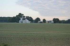 Farm on Nurrenbern Road | |
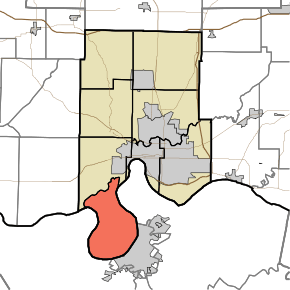 Location in Vanderburgh County | |
| Coordinates: 37°52′31″N 87°37′50″W | |
| Country | United States |
| State | Indiana |
| County | Vanderburgh |
| Government | |
| • Type | Indiana township |
| Area | |
| • Total | 28.09 sq mi (72.8 km2) |
| • Land | 27.54 sq mi (71.3 km2) |
| • Water | 0.55 sq mi (1.4 km2) 1.96% |
| Elevation | 361 ft (110 m) |
| Population (2010) | |
| • Total | 292 |
| • Density | 10.6/sq mi (4.1/km2) |
| ZIP code | 47712 |
| GNIS feature ID | 453937 |
History
Union Township was organized in 1819.[2] It was the subject of Handly's Lessee v. Anthony, a case before the United States Supreme Court regarding the border between Indiana and Kentucky.
Geography
According to the 2010 census, the township has a total area of 28.09 square miles (72.8 km2), of which 27.54 square miles (71.3 km2) (or 98.04%) is land and 0.55 square miles (1.4 km2) (or 1.96%) is water.[1]
Adjacent townships
- Perry Township (north)
Cemeteries
The township contains Stroud Cemetery.
Rivers
School districts
- Evansville-Vanderburgh School Corporation
Political districts
- Indiana's 8th congressional district
- State House District 76
- State Senate District 49
References
- "Union Township, Vanderburgh County, Indiana". Geographic Names Information System. United States Geological Survey. Retrieved 2010-02-20.
- United States Census Bureau 2007 TIGER/Line Shapefiles
- IndianaMap
- "Population, Housing Units, Area, and Density: 2010 - County -- County Subdivision and Place -- 2010 Census Summary File 1". United States Census. Archived from the original on 2020-02-12. Retrieved 2013-05-10.
- History of Vanderburgh County, Indiana: From the Earliest Times to the Present. Brant & Fuller. 1889. p. 62.
External links
Places adjacent to Union Township, Vanderburgh County, Indiana | ||||||||||
|---|---|---|---|---|---|---|---|---|---|---|
| ||||||||||
Municipalities and communities of Vanderburgh County, Indiana, United States | ||
|---|---|---|
| City | Map of Indiana highlighting Vanderburgh County | |
| Town | ||
| Townships | ||
| CDPs | ||
| Unincorporated communities | ||
| Footnotes | ‡This populated place also has portions in an adjacent county or counties | |
This article is issued from Wikipedia. The text is licensed under Creative Commons - Attribution - Sharealike. Additional terms may apply for the media files.